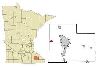
Byron is a city in Olmsted County, Minnesota, United States, approximately five miles (8 km) west of Rochester on U.S. Route 14. It is surrounded by Kalmar Township. The population was 6,312 at the 2020 census.

Elcho is a town in Langlade County, Wisconsin, United States. The population was 1,233 at the 2010 census. The census-designated places of Elcho, Post Lake, and part of Summit Lake are located in the town. The area is served by the Elcho Fire and Rescue Department.
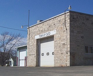
Cato is a town in Manitowoc County, Wisconsin, United States. The population was 1,616 at the 2000 census. A Manitowoc County park is located in the town which is called "Cato Falls" for a waterfall on the Manitowoc River.

Stella is a town in Oneida County, Wisconsin, United States. The population was 633 at the 2000 census. The unincorporated community of Starks is located within the town.

Van Tassell is a town in Niobrara County, Wyoming, United States. The population was 15 at the 2010 census. It is the least populous town in the least populous county of the least populous state in the U.S.

Kewaskum is a town in Washington County, Wisconsin, United States. The population was 1,119 at the 2000 census. The incorporated community of Village of Kewaskum is surrounded geographically by the Town of Kewaskum. The unincorporated community of Saint Michaels is located partially in the town.
Elmhurst is an unincorporated community in Langlade County, Wisconsin, United States. It is in the town of Rolling at latitude 45°3'30" North, longitude 89°11'3" West. The community is located near the headwaters of the Middle Branch Embarrass River, approximately 1½ miles west of the junction of WIS 47, WIS 52 and U.S. Highway 45 in the Town of Rolling. A track of the Chicago and North Western Railway runs along the west side of the community. Elmhurst is located at 1,476 feet (450 m) above sea level.
Houghton is an unincorporated community in Brown County, South Dakota, United States. Its population is not tracked by the Census Bureau. Houghton is the site of a post office serving ZIP code 57449.

Shopiere is an unincorporated community and census-designated place in the Town of Turtle, in Rock County, Wisconsin, United States. It was first named a CDP at the 2020 census, which showed a population of 154.
Watkins is an unincorporated community and census-designated place in southeastern Benton County, Iowa, United States. As of the 2010 census, it had a population of 118. Watkins lies along local roads south of the city of Vinton, the county seat of Benton County. Its elevation is 830 feet (250 m) above sea level. Although Watkins is unincorporated, it has a post office, with the ZIP code of 52354, which opened on 15 December 1873.

Denmark is an unincorporated community and census-designated place in northeastern Lee County, Iowa, United States. It lies along Iowa Highway 16, north of the city of Fort Madison, the county seat of Lee County. Its elevation is 722 feet (220 m) above sea level. Although Denmark is unincorporated, it has a post office with the ZIP code of 52624, that opened on April 7, 1846. The town also has a branch of Farmers Savings Bank that opened in 1935. The community is part of the Fort Madison–Keokuk, IA-MO Micropolitan Statistical Area. As of the 2020 census, its population was 425.

Van Dyne is an unincorporated community and census-designated place in the town of Friendship, in Fond du Lac County, Wisconsin, United States. At the 2020 census, its population was 292. The road traveling north-south through the community was part of the Yellowstone Trail and later Wisconsin Highway 175; it is now a county highway.
Nachusa is an unincorporated community in Lee County, Illinois, United States, located 5 miles (8.0 km) east of Dixon. Nachusa has a post office with ZIP code 61057. Nachusa is located on the old C&NW main line between Chicago and Omaha.
Lawrence is an unincorporated community and census-designated place in Chemung Township, McHenry County, Illinois, United States. Lawrence is 2 miles (3.2 km) northwest of Harvard. It was named a CDP before the 2020 census, at which time it had a population of 220.
Emerald is a census-designated place in St. Croix County, Wisconsin, United States. Emerald is located in the towns of Emerald and Glenwood, 4.5 miles (7.2 km) west-northwest of Glenwood City. As of the 2010 census, its population was 161.
Lake Tomahawk is an unincorporated census-designated place located in the town of Lake Tomahawk, Oneida County, Wisconsin, United States. Lake Tomahawk is located on Wisconsin Highway 47 15 miles (24 km) northwest of Rhinelander. Lake Tomahawk has a post office with ZIP code 54539. As of the 2010 census, its population was 228.

Three Lakes is an unincorporated census-designated place located in the town of Three Lakes, Oneida County, Wisconsin, United States. Three Lakes is located at the junction of U.S. Route 45 and Wisconsin Highway 32 9 miles (14 km) south-southeast of Eagle River. Three Lakes has a post office with ZIP code 54562. As of the 2010 census, its population is 605.

California Junction is an unincorporated community and census-designated place (CDP) in Harrison County, Iowa, United States. It lies just east of the junction between the east–west and north–south lines of the former Sioux City and Pacific Railroad. In the 2010 census it had a population of 85 inhabitants and a population density of 184.38 people per square mile.
Van Buskirk is an unincorporated community located in the town of Oma, Iron County, Wisconsin, United States.
Secor, previously known as Xenia and Delanti, is a ghost town in Hardin County, Iowa, United States. The community was 3.5 miles (5.6 km) south-southeast of Eldora. In its early years, the community was the site of one of the few bridges across the Iowa River in Hardin County. By the mid-20th century, however, the community had lost its school, mill, post office, and businesses, and Secor was considered a ghost town.


