
Cape Town is the second-most populous city in South Africa, after Johannesburg, and also the legislative capital of South Africa.

Pretoria is one of South Africa’s three capital cities, serving as the seat of the executive branch of government, and as the host to all foreign embassies to South Africa.

The Province of the Cape of Good Hope, commonly referred to as the Cape Province and colloquially as The Cape, was a province in the Union of South Africa and subsequently the Republic of South Africa. It encompassed the old Cape Colony, as well as Walvis Bay, and had Cape Town as its capital. In 1994, the Cape Province was split up to form the new Eastern Cape, Northern Cape and Western Cape provinces, along with part of the North West.

South Africa occupies the southern tip of Africa, its coastline stretching more than 2,850 kilometres from the desert border with Namibia on the Atlantic (western) coast southwards around the tip of Africa and then northeast to the border with Mozambique on the Indian Ocean. The low-lying coastal zone is narrow for much of that distance, soon giving way to a mountainous escarpment that separates the coast from the high inland plateau. In some places, notably the province of KwaZulu-Natal in the east, a greater distance separates the coast from the escarpment. Although much of the country is classified as semi-arid, it has considerable variation in climate as well as topography. The total land area is 1,220,813 km2 (471,359 sq mi). It has the 23rd largest Exclusive Economic Zone of 1,535,538 km2 (592,875 sq mi).
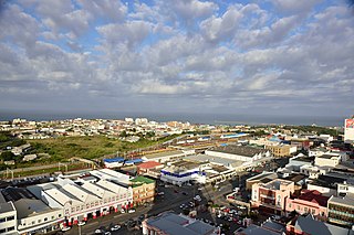
East London is a city on the southeast coast of South Africa in the Buffalo City Metropolitan Municipality of the Eastern Cape province. The city lies on the Indian Ocean coast, largely between the Buffalo River and the Nahoon River, and hosts the country's only river port. As of 2011, East London had a population of over 267,000 with over 755,000 in the metropolitan area.

Ermelo is the educational, industrial and commercial town of the 7,750 km2 Gert Sibande District Municipality in Mpumalanga province, Republic of South Africa. It is both a mixed agriculture and mining region. It is located 210 km east of Johannesburg.

Mookgophong, also known by its former name, Naboomspruit, is a town in the Limpopo province of South Africa. The town is located approximately 42 km north-east of Modimolle and 51 km south-west of Mokopane.

Delareyville is a maize- and peanut-farming town situated in North West Province of South Africa. The town is 96 km south-west of Lichtenburg, 82 km north-east of Vryburg, 114 km north-west of Wolmaransstad, and 61 km north of Schweizer-Reneke.

Port Alfred is a small town with a population of just under 26,000 in the Eastern Cape province of South Africa. It is situated on the eastern seaboard of the country at the mouth of the Kowie River, almost exactly halfway between the larger cities of Port Elizabeth and East London and 30 kilometres (19 mi) west of Cannon Rocks.

Aberdeen is a small town in the Sarah Baartman District Municipality of the Eastern Cape province of South Africa. With its numerous examples of Victorian architecture, it is one of the architectural conservation areas of the Karoo.
Melkbosstrand is a coastal town located on the South West Coast of South Africa, 30 km north of Cape Town. It forms part of the City of Cape Town Metropolitan Municipality, the municipality governing Cape Town and its greater metropolitan area.

Prieska is a town on the south bank of the Orange River, in the province of the Northern Cape, in western South Africa. It is located on the southern bank of the Orange River, 130 km north-west of Britstown and 75 km south-east of Marydale.

Postmasburg is a town in the Northern Cape province of South Africa, located approximately 170 km east of Upington.

Rondebosch East is a residential suburb of Cape Town, South Africa, about 7 kilometres (4.3 mi) south-west of the city centre. As the name suggests, it is located to the east of the neighbouring suburb of Rondebosch. As of 2001 it had a population of approximately 4,600 people in an area of just over 1 square kilometre (0.4 sq mi).
Bothasig is a suburban area of the City of Cape Town in Western Cape, South Africa. It is located north of Edgemead and east of Milnerton. It is located approximately 15 km north-east of the Cape Town city centre.

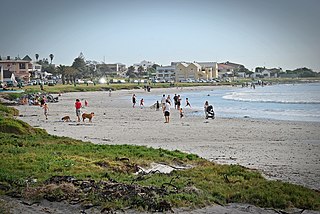
Saint Helena Bay is a settlement in West Coast District Municipality in the Western Cape province of South Africa.

Willowmore is a town in Sarah Baartman District Municipality in the Eastern Cape province of South Africa.

Middledrift is a small town located 90 kilometres (60 mi) north-west of East London in the Eastern Cape province of South Africa. It is situated in Raymond Mhlaba Municipality in Amathole District in an area that was formerly part of the Ciskei.
Spoegrivier is a town in Namakwa District Municipality in the Northern Cape province of South Africa.


