Washington Township, Lycoming County, Pennsylvania

Last updated
Washington Township,
Lycoming County,
Pennsylvania
White Deer Hole Valley crop.JPG
Farms and woodlands in Washington Township with the second-growth Tiadaghton State Forest on South White Deer Ridge behind
Map of Lycoming County Pennsylvania Highlighting Washington Township.png
Location of Washington Township in Lycoming County, Pennsylvania
Map of Pennsylvania highlighting Lycoming County.svg
Map of Lycoming County, Pennsylvania
Coordinates: 41°7′21″N77°2′37″W / 41.12250°N 77.04361°W / 41.12250; -77.04361
Country United States
State Pennsylvania
County Lycoming
Settled1760
Formed1786
Area
[1]
  Total48.33 sq mi (125.16 km2)
  Land48.22 sq mi (124.89 km2)
  Water0.11 sq mi (0.28 km2)
Elevation
1,447 ft (441 m)
Population
 (2020) [2]
  Total1,769 Increase2.svg
  Estimate 
(2021) [2]
1,761
  Density34.41/sq mi (13.28/km2)
Time zone UTC-5 (Eastern Time Zone (North America))
  Summer (DST) UTC-4 (EDT)
FIPS code 42-081-81288
GNIS feature ID1216775 [3]
Website washingtontwplyc.com

Washington Township is a township in Lycoming County, Pennsylvania, United States. The population was 1,769 at the 2020 census. [2] It is part of the Williamsport Metropolitan Statistical Area.

Contents

History

Washington Township was formed as part of Northumberland County in 1786. It originally extended from White Deer Hole Creek north to the West Branch Susquehanna River, with its eastern boundary also formed by the West Branch. The western limit was ambiguous, but most historians assumed that the western boundary followed a line that extended to the south opposite the mouth of Pine Creek in what is now eastern Clinton County. Washington Township is older than Lycoming County. Therefore, it was one of the original townships in Lycoming County. Seven additional townships were created from land that was originally part of Washington Township. They are Armstrong, Bastress, Brady, Clinton, Limestone, Nippenose, and Susquehanna townships. [4] The township is named for the hero of the American Revolution and the first President of the United States, George Washington.

Historically, two trails of the native indigenous peoples ran along parts of White Deer Hole Creek in Washington Township. Settlers arrived by 1760, but fled in 1778 during the American Revolutionary War during the Big Runaway. They returned, and the creek served as the southern boundary of Lycoming County and Washington Township when it was formed in 1795. A logging railroad ran along the creek from 1901 to 1904 for timber clearcutting, and small-scale lumbering continues.

White Deer Hole Creek near First Gap in South White Deer Ridge in Washington Township White Deer Hole Creek near 1st Gap.JPG
White Deer Hole Creek near First Gap in South White Deer Ridge in Washington Township

The Great Island Path was a major trail that ran north along the Susquehanna River from the Saponi village of Shamokin at modern Sunbury, fording the West Branch of the Susquehanna there and following the west bank of the river north until the White Deer Hole valley. The path turned west at Allenwood and followed White Deer Hole Creek until about the present location of Elimsport in Washington Township. There it headed northwest, crossed North White Deer Ridge and passed west through the Nippenose Valley, then turned north and crossed Bald Eagle Mountain via McElhattan Creek and ran along the south bank of the West Branch to the Great Island (near the present day city of Lock Haven). [5]

In the Revolutionary War, settlements throughout the Susquehanna valley were attacked by Loyalists and Native Americans allied with the British. After the Wyoming Valley battle and massacre in the summer of 1778 (near what is now Wilkes-Barre) and smaller local attacks, the Big Runaway occurred throughout the West Branch Susquehanna valley. Settlers fled feared and actual attacks by the British and their allies. Settlers abandoned their homes and fields, drove their livestock south, and towed their possessions on rafts on the river to Sunbury. Their abandoned property was burnt by the attackers. Some settlers soon returned, only to flee again in the summer of 1779 in the "Little Runaway". [6]

Beginning with the first settlers, much of the land along White Deer Hole Creek in Washington Township was slowly cleared of timber. Small sawmills were built in the 19th century, and a much larger lumber operation was run by the Vincent Lumber Company from 1901 to 1904. They built a 3 ft (914 mm) narrow-gauge railroad from Elimsport 5 miles (8 km) west into timber, and a line east to Allenwood in Union County and the Reading Railroad there. The lumber railroad ran parallel to the creek, with the end of the track near Fourth Gap. It was incorporated on June 24, 1901 (around the time of construction) as the "Allenwood and Western Railroad". The lumbering operation ceased in 1904 when the forests were gone. The railroad was torn up, and its one second-hand Shay locomotive was moved to the Vincent Lumber Company operation at Denholm in Juniata County. [7]

From 1900 to 1935, much of what is now Tiadaghton State Forest was purchased by Pennsylvania from lumber companies that had no further use for the clear-cut land. In the 1930s there were seven Civilian Conservation Corps camps to construct roads and trails in the forest. [8]

On May 31, 1985, around 10:30 pm, a tornado tore through the eastern part of the township, went through the State Gamelands (Old Alvira), and continued into Union County with no warning. Twelve people were injured and one was killed.

Small-scale lumbering continues in the Washington Township, but the forest is certified as well-managed "in an environmentally sensitive manner", and lumber from it qualifies for a "green label". [8] An Amish-owned and operated sawmill is on Pennsylvania Route 44 in Elimsport. It burned down on May 10, 2006 (causing $500,000 in damages) but was expected to be back in operation in a month. [9] Despite this small-scale lumbering, as of 2006 the forests have grown back and are mixed oak, with blueberry and mountain laurel bushes. White Deer Hole Creek and its tributaries also have stands of hemlock and thickets of rhododendron along them. [10]

Geography

Washington Township is in southern Lycoming County and is bordered by Clinton County to the west, Limestone Township to the northwest, Armstrong Township to the north, Brady Township to the northeast, and Union County to the east and south. [11] It is 10 miles (16 km) south of Williamsport, the Lycoming county seat, and 78 miles (126 km) north of Harrisburg, the state capital. Pennsylvania Route 44 crosses the township, passing through Elimsport, the one unincorporated community in the township. PA-44 leads east from Elimsport 6 miles (10 km) to Allenwood on the West Branch of the Susquehanna River and northwest over North White Deer Ridge 16 miles (26 km) to Jersey Shore, also on the West Branch.

According to the United States Census Bureau, the township has a total area of 48.33 square miles (125.2 km2), of which 0.11 square miles (0.28 km2), or 0.23%, are water. [1]

Demographics

Historical population
CensusPop.Note
2010 1,619
2020 1,7699.3%
2021 (est.)1,761 [2] −0.5%
U.S. Decennial Census [12]

As of the census [13] of 2000, there were 1,613 people, 549 households, and 462 families residing in the township. The population density was 33.2 inhabitants per square mile (12.8/km2). There were 639 housing units at an average density of 13.2/sq mi (5.1/km2). The racial makeup of the township was 98.57% White, 0.19% African American, 0.37% Native American, 0.12% Asian, 0.12% from other races, and 0.62% from two or more races. Hispanic or Latino of any race were 0.19% of the population.

An Amish school just off PA Rt. 554 Washington Township Amish School.JPG
An Amish school just off PA Rt. 554

There were 549 households, out of which 39.2% had children under the age of 18 living with them, 76.7% were married couples living together, 4.7% had a female householder with no husband present, and 15.8% were non-families. 13.1% of all households were made up of individuals, and 6.0% had someone living alone who was 65 years of age or older. The average household size was 2.94 and the average family size was 3.21.

In the township the population was spread out, with 28.9% under the age of 18, 7.1% from 18 to 24, 28.5% from 25 to 44, 24.5% from 45 to 64, and 11.1% who were 65 years of age or older. The median age was 36 years. For every 100 females there were 108.4 males. For every 100 females age 18 and over, there were 104.5 males.

The median income for a household in the township was $41,739, and the median income for a family was $45,804. Males had a median income of $31,098 versus $22,031 for females. The per capita income for the township was $17,124. About 6.5% of families and 10.3% of the population were below the poverty line, including 17.4% of those under age 18 and 4.0% of those age 65 or over.

Related Research Articles

<span class="mw-page-title-main">Lycoming County, Pennsylvania</span> County in Pennsylvania, United States

Lycoming County is a county in the Commonwealth of Pennsylvania. As of the 2020 census, the population was 114,188. Its county seat is Williamsport.

<span class="mw-page-title-main">Armstrong Township, Lycoming County, Pennsylvania</span> Township in Pennsylvania, United States

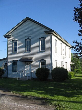
Armstrong Township is a township in Lycoming County, Pennsylvania, United States. The population was 685 at the 2020 census. It is part of the Williamsport, Pennsylvania Metropolitan Statistical Area.

<span class="mw-page-title-main">Brady Township, Lycoming County, Pennsylvania</span> Township in Pennsylvania, United States

Brady Township is a township in Lycoming County, Pennsylvania, United States. The population was 502 at the 2020 census. It is part of the Williamsport Metropolitan Statistical Area.

<span class="mw-page-title-main">Brown Township, Lycoming County, Pennsylvania</span> Township in Pennsylvania, United States

Brown Township is a township in Lycoming County, Pennsylvania, United States. The population was 92 at the 2020 census. It is part of the Williamsport, Pennsylvania Metropolitan Statistical Area.

<span class="mw-page-title-main">Clinton Township, Lycoming County, Pennsylvania</span> Township in Pennsylvania, United States

Clinton Township is a township in Lycoming County, Pennsylvania, United States. The population was 3,719 at the 2020 census, up from 3,708 in 2010. It is part of the Williamsport, Pennsylvania Metropolitan Statistical Area.

<span class="mw-page-title-main">Cummings Township, Lycoming County, Pennsylvania</span> Township in Pennsylvania, United States

Cummings Township is a township in Lycoming County, Pennsylvania, United States. The population was 264 at the 2020 census, down from 273 in 2010. It is part of the Williamsport, Pennsylvania Metropolitan Statistical Area. Cummings Township is home to Little Pine State Park and Upper Pine Bottom State Park.

<span class="mw-page-title-main">Limestone Township, Lycoming County, Pennsylvania</span> Township in Pennsylvania, United States

Limestone Township is a township in Lycoming County, Pennsylvania, United States. The population was 1,968 at the 2020 census. It is part of the Williamsport Metropolitan Statistical Area.

<span class="mw-page-title-main">Loyalsock Township, Pennsylvania</span> Township in Pennsylvania, United States

Loyalsock Township is a township in Lycoming County, Pennsylvania, United States. The population was 11,561 at the 2020 census. It is part of the Williamsport Metropolitan Statistical Area. It is the second largest municipality in Lycoming County, in terms of population, behind the county seat, Williamsport.

<span class="mw-page-title-main">Mifflin Township, Lycoming County, Pennsylvania</span> Township in Pennsylvania, United States

Mifflin Township is a township in Lycoming County, Pennsylvania, United States. The population was 1,088 at the 2020 census. It is part of the Williamsport Metropolitan Statistical Area.

<span class="mw-page-title-main">Nippenose Township, Pennsylvania</span> Township in Pennsylvania, United States

Nippenose Township is a township in Lycoming County, Pennsylvania, United States. The population was 662 at the 2020 census. It is part of the Williamsport, Pennsylvania Metropolitan Statistical Area.

<span class="mw-page-title-main">Piatt Township, Pennsylvania</span> Township in Pennsylvania, United States

Piatt Township is a township in Lycoming County, Pennsylvania, United States. The population was 1,045 at the 2020 census. It is part of the Williamsport Metropolitan Statistical Area.

<span class="mw-page-title-main">Porter Township, Lycoming County, Pennsylvania</span> Township in Pennsylvania, United States

Porter Township is a township in Lycoming County, Pennsylvania, United States. The population was 1,535 at the 2020 census. It is part of the Williamsport Metropolitan Statistical Area.

<span class="mw-page-title-main">West Branch Susquehanna River</span> River in Pennsylvania, United States

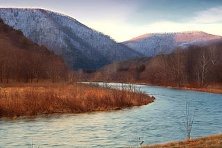
The West Branch Susquehanna River is one of the two principal branches, along with the North Branch, of the Susquehanna River in the Northeastern United States. The North Branch, which rises in upstate New York, is generally regarded as the extension of the main branch, with the shorter West Branch being its principal tributary.

<span class="mw-page-title-main">Lycoming Creek</span> River in Pennsylvania, United States

Lycoming Creek is a 37.5-mile-long (60.4 km) tributary of the West Branch Susquehanna River located in Tioga and Lycoming counties in Pennsylvania in the United States.

<span class="mw-page-title-main">Pine Creek (Pennsylvania)</span> Creek in Pennsylvania, United States

Pine Creek is a tributary of the West Branch Susquehanna River in Potter, Tioga, Lycoming, and Clinton counties in Pennsylvania. The creek is 87.2 miles (140.3 km) long. Within Tioga County, 23.25 miles (37.42 km) of Pine Creek are designated as a Pennsylvania Scenic River.

<span class="mw-page-title-main">White Deer Hole Creek</span> Tributary of the West Branch Susquehanna River

White Deer Hole Creek is a 20.5-mile (33.0 km) tributary of the West Branch Susquehanna River in Clinton, Lycoming and Union counties in the U.S. state of Pennsylvania. A part of the Chesapeake Bay drainage basin, the White Deer Hole Creek watershed drains parts of ten townships. The creek flows east in a valley of the Ridge-and-valley Appalachians, through sandstone, limestone, and shale from the Ordovician, Silurian, and Devonian periods.

<span class="mw-page-title-main">Tiadaghton State Forest</span> State forest in Pennsylvania, United States

Tiadaghton State Forest is a Pennsylvania State Forest in the Pennsylvania Department of Conservation and Natural Resources, Bureau of Forestry. The forest is primarily in western and southern Lycoming County, with small portions in Clinton, Potter, Tioga, and Union Counties. The district's topography consists of narrow, flat to sloping plateaus cut by deep, steep-sloped valleys carved by fast moving mountain streams, including Pine Creek, Slate Run, and their tributaries. The Tiadaghton district extends south across the lowland along the west branch of the Susquehanna River to the narrow crests of Bald Eagle Mountain and North and South White Deer Ridge. The majority of forest cover is dominated by mixed oak forests, with some areas of northern hardwoods. The Tiadaghton State Forest is one of eight forest districts in the Pennsylvania Wilds region.

<span class="mw-page-title-main">Culbertson's Path</span> Native American trail in Pennsylvania, US

Culbertson's Path was a Native American trail in north central Pennsylvania in the United States, which connected the Great Island Path with the Sheshequin Path. The eastern / southern end of the path was on the West Branch Susquehanna River at what is now the village of Allenwood in Gregg Township, Union County. The northern / western end was in Old Lycoming Township just north of what is now the city of Williamsport in Lycoming County.

<span class="mw-page-title-main">Upper Pine Bottom State Park</span> State park in Lycoming County, Pennsylvania, United States

Upper Pine Bottom State Park is a 5-acre (2.0 ha) Pennsylvania state park in Lycoming County, Pennsylvania in the United States. The park is in Cummings Township on Pennsylvania Route 44 and is surrounded by the Tiadaghton State Forest. It is on Upper Pine Bottom Run, which gave the park its name and is a tributary of Pine Creek. Upper Pine Bottom State Park is in the Pine Creek Gorge, where the streams have cut through five major rock formations from the Devonian and Carboniferous periods.

<span class="mw-page-title-main">West Branch Susquehanna Valley</span>

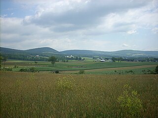
The West Branch Susquehanna Valley of central Pennsylvania, United States, in the Ridge-and-valley Appalachians, is the low-lying area draining into the West Branch Susquehanna River southeast of the Allegheny Front, northeast of the Bald Eagle Valley, southwest of the Wyoming Valley and north of the water gap formed between Shamokin Mountain and Montour Ridge.

References

  1. 1 2 "2016 U.S. Gazetteer Files". United States Census Bureau. Retrieved Aug 14, 2017.
  2. 1 2 3 4 Bureau, US Census. "City and Town Population Totals: 2020-2021". Census.gov. US Census Bureau. Retrieved 15 July 2022.
  3. "US Board on Geographic Names". United States Geological Survey. 2007-10-25. Retrieved 2008-01-31.
  4. Meginness, John Franklin (1892). "Washington, Clinton, Armstrong, and Brady". History of Lycoming County, Pennsylvania: including its aboriginal history; the colonial and revolutionary periods; early settlement and subsequent growth; organization and civil administration; the legal and medical professions; internal improvement; past and present history of Williamsport; manufacturing and lumber interests; religious, educational, and social development; geology and agriculture; military record; sketches of boroughs, townships, and villages; portraits and biographies of pioneers and representative citizens, etc. etc (1st ed.). Chicago: Brown, Runk & Co. ISBN   0-7884-0428-8 . Retrieved 2007-04-24. (Note: ISBN refers to Heritage Books July 1996 reprint. URL is to a scan of the 1892 version with some OCR typos).
  5. Wallace, Paul A.W. (1987). Indian Paths of Pennsylvania (Fourth Printing ed.). Harrisburg, Pennsylvania: Pennsylvania Historical and Museum Commission. pp. 42, 63–64. ISBN   0-89271-090-X. (Note: ISBN refers to 1998 impression.)
  6. A Picture of Lycoming County (PDF). The Lycoming County Unit of the Pennsylvania Writers Project of the Work Projects Administration (First ed.). The Commissioners of Lycoming County Pennsylvania. 1939. Retrieved 2006-07-23.{{cite book}}: CS1 maint: others (link)
  7. Taber, Thomas T., III (1987). Railroads of Pennsylvania Encyclopedia and Atlas. Thomas T. Taber III. ISBN   0-9603398-5-X.{{cite book}}: CS1 maint: multiple names: authors list (link)
  8. 1 2 Pennsylvania Department of Conservation and Natural Resources (November 2004). "A Public Use Map for Tiadaghton State Forest".
  9. Holmes, Philip A. (May 13, 2006). "Fire claims Route 44 sawmill". Williamsport Sun-Gazette . Retrieved 2006-11-20.
  10. Pennsylvania Department of Conservation and Natural Resources (2002). "Central Mountains Shared Use Trails System: Union, Lycoming and Clinton Counties, Bald Eagle and Tiadaghton State Forests".
  11. "2007 General Highway Map Lycoming County Pennsylvania" (PDF) (Map). 1:65,000. Pennsylvania Department of Transportation, Bureau of Planning and Research, Geographic Information Division. Retrieved 2009-12-26.
  12. "Census of Population and Housing". Census.gov. Retrieved June 4, 2016.
  13. "U.S. Census website". United States Census Bureau . Retrieved 2008-01-31.