
The Willamette River is a major tributary of the Columbia River, accounting for 12 to 15 percent of the Columbia's flow. The Willamette's main stem is 187 miles (301 km) long, lying entirely in northwestern Oregon in the United States. Flowing northward between the Oregon Coast Range and the Cascade Range, the river and its tributaries form the Willamette Valley, a basin that contains two-thirds of Oregon's population, including the state capital, Salem, and the state's largest city, Portland, which surrounds the Willamette's mouth at the Columbia.
Chinook Jargon is a language originating as a pidgin trade language in the Pacific Northwest. It spread during the 19th century from the lower Columbia River, first to other areas in modern Oregon and Washington, then to British Columbia and parts of Alaska, Northern California, Idaho and Montana, sometimes taking on the characteristics of a creole language. It is partly descended from the Chinook language, upon which much of its vocabulary is based. Approximately 15 percent of its lexicon is French, and it also makes use of English loan words and those of other language systems. Its entire written form is in the Duployan shorthand developed by French priest Émile Duployé.

Chinookan peoples include several groups of Indigenous people of the Pacific Northwest in the United States who speak the Chinookan languages. Since at least 4000 BCE Chinookan peoples have resided along the upper and Middle Columbia River (Wimahl) from the river's gorge downstream (west) to the river's mouth, and along adjacent portions of the coasts, from Tillamook Head of present-day Oregon in the south, north to Willapa Bay in southwest Washington. In 1805 the Lewis and Clark Expedition encountered the Chinook Tribe on the lower Columbia.

The Hawthorne Bridge is a truss bridge with a vertical lift that spans the Willamette River in Portland, Oregon, joining Hawthorne Boulevard and Madison Street. It is the oldest vertical-lift bridge in operation in the United States and the oldest highway bridge in Portland. It is also the busiest bicycle and transit bridge in Oregon, with over 8,000 cyclists and 800 TriMet buses daily. It was added to the National Register of Historic Places in November 2012.
The Multnomah are a tribe of Chinookan people who live in the area of Portland, Oregon, in the United States. Multnomah villages were located throughout the Portland basin and on both sides of the Columbia River. The Multnomah speak a dialect of the Upper Chinookan language in the Oregon Penutian family.

The Willamette Falls is a natural waterfall on the Willamette River between Oregon City and West Linn, Oregon, in the United States. It is the largest waterfall in the Northwestern United States by volume, and the seventeenth widest in the world. Horseshoe in shape, it is 1,500 feet (460 m) wide and 40 feet (12 m) high with a flow of 30,849 cu ft/s, located 26 miles (42 km) upriver from the Willamette's mouth. Willamette Falls is a culturally significant site for many tribal communities in the region.
Like transportation in the rest of the United States, the primary mode of local transportation in Portland, Oregon is the automobile. Metro, the metropolitan area's regional government, has a regional master plan in which transit-oriented development plays a major role. This approach, part of the new urbanism, promotes mixed-use and high-density development around light rail stops and transit centers, and the investment of the metropolitan area's share of federal tax dollars into multiple modes of transportation. In the United States, this focus is atypical in an era when automobile use led many areas to neglect their core cities in favor of development along interstate highways, in suburbs, and satellite cities.
Portland is "an international pioneer in transit orientated developments."

Downtown Portland is the central business district of Portland, Oregon, United States. It is on the west bank of the Willamette River in the northeastern corner of the southwest section of the city and where most of the city's high-rise buildings are found.
The MAX Orange Line is a light rail line serving the Portland metropolitan area in the U.S. state of Oregon. Operated by TriMet as part of the MAX Light Rail system, it connects Portland City Center, Portland State University (PSU), Southeast Portland, Milwaukie, and Oak Grove. The line serves 17 stations and runs for 201⁄2 hours per day with headways of up to 15 minutes. It averaged 3,480 daily weekday riders in September 2020.

The Klickitat are a Native American tribe of the Pacific Northwest. Today most Klickitat are enrolled in the federally recognized Confederated Tribes and Bands of the Yakama Nation, some are also part of the Confederated Tribes of the Grand Ronde Community of Oregon.

The South Waterfront is a high-rise district under construction on former brownfield industrial land in the South Portland neighborhood south of downtown Portland, Oregon, U.S. It is one of the largest urban redevelopment projects in the United States. It is connected to downtown Portland by the Portland Streetcar and MAX Orange Line, and to the Oregon Health & Science University (OHSU) main campus atop Marquam Hill by the Portland Aerial Tram, as well as roads to Interstate 5 and Oregon Route 43.

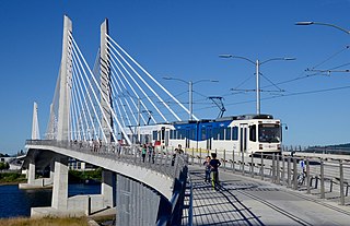
Tilikum Crossing, Bridge of the People is a cable-stayed bridge across the Willamette River in Portland, Oregon, United States. It was designed by TriMet, the Portland metropolitan area's regional transit authority, for its MAX Orange Line light rail passenger trains. The bridge also serves city buses and the Portland Streetcar, as well as bicycles, pedestrians, and emergency vehicles. Private cars and trucks are not permitted on the bridge. It is the first major bridge in the U.S. that was designed to allow access to transit vehicles, cyclists and pedestrians but not cars.

The Providence Bridge Pedal, formerly known as the Portland Bridge Pedal is an annual recreational cycling and walking event across several Willamette River crossings in Portland, Oregon. Oregon State Representative Rick Bauman is credited with conceiving the event while watching the 1980 eruption of Mount St. Helens on the Marquam Bridge. By 2007 it became the world's third largest annual recreational cycling event behind the Five Boro Bike Tour in New York City, New York and Tour de l'Île in Montreal, Quebec.

Living Room was an outdoor 2001 sculpture by Tamsie Ringler, installed at the Gresham Central Transit Center in Gresham, Oregon, United States.

The A and B Loop is a streetcar circle route of the Portland Streetcar system in Portland, Oregon, United States. Operated by Portland Streetcar, Inc. and TriMet, it is made up of two separate services: the 6.1-mile (9.8 km) A Loop, which runs clockwise, and the 6.6-mile (10.6 km) B Loop, which runs counterclockwise. The route travels a loop between the east and west sides of the Willamette River by crossing the Broadway Bridge in the north and Tilikum Crossing in the south.

South Waterfront/South Moody, formerly South Waterfront/Southwest Moody, is a combined light rail and bus station located at 698 Southwest Porter Street in the South Waterfront neighborhood of Portland, Oregon, at the west end of the Tilikum Crossing bridge. It is serviced by the MAX Orange Line and TriMet buses. Portland Streetcar travels through it but does not service it.

OMSI/Southeast Water station is a light rail station on the MAX Orange Line, located at 2210 Southeast 2nd Place on the east foot of the Tilikum Crossing bridge in Portland, Oregon. Like South Waterfront/SW Moody Station on the west side of the Willamette River, it consists of two island platforms. MAX trains stop on the outside of the platforms, while TriMet buses stop on the inner lanes. Just northwest of the platforms is a Portland Streetcar stop served by the A and B Loop lines. The station is named after the nearby Oregon Museum of Science and Industry.

Tri It is an outdoor 2015 mural by Blaine Fontana, painted outside the TriMet Bus Maintenance Facility in Portland, Oregon, in the United States.
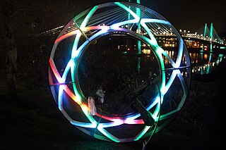
The Portland Winter Light Festival is an annual winter light festival in Portland, Oregon. Each year has been presented by the local nonprofit Willamette Light Brigade. The festival is open to the public and free to attend.

Poet's Beach is an urban beach along the Willamette River, near Portland, Oregon's Marquam Bridge, in the United States.


