The Holocene is the current geological epoch. It began approximately 9,700 years before the Common Era (BCE). It follows the Last Glacial Period, which concluded with the Holocene glacial retreat. The Holocene and the preceding Pleistocene together form the Quaternary period. The Holocene has been identified with the current warm period, known as MIS 1. It is considered by some to be an interglacial period within the Pleistocene Epoch, called the Flandrian interglacial.

A monsoon is traditionally a seasonal reversing wind accompanied by corresponding changes in precipitation but is now used to describe seasonal changes in atmospheric circulation and precipitation associated with annual latitudinal oscillation of the Intertropical Convergence Zone (ITCZ) between its limits to the north and south of the equator. Usually, the term monsoon is used to refer to the rainy phase of a seasonally changing pattern, although technically there is also a dry phase. The term is also sometimes used to describe locally heavy but short-term rains.

The Last Glacial Maximum (LGM), also referred to as the Last Glacial Coldest Period, was the most recent time during the Last Glacial Period that ice sheets were at their greatest extent 26 ka – 20 ka ago. Ice sheets covered much of Northern North America, Northern Europe, and Asia and profoundly affected Earth's climate by causing a major expansion of deserts, along with a large drop in sea levels.
The Holocene Climate Optimum (HCO) was a warm period that occurred in the interval roughly 9,500 to 5,500 years ago BP, with a thermal maximum around 8000 years BP. It has also been known by many other names, such as Altithermal, Climatic Optimum, Holocene Megathermal, Holocene Optimum, Holocene Thermal Maximum, Hypsithermal, and Mid-Holocene Warm Period.

The N2 is a national route in South Africa that runs from Cape Town through George, Gqeberha, East London, Mthatha, Port Shepstone and Durban to Ermelo. It is the main highway along the Indian Ocean coast of the country. Its current length of 2,255 kilometres (1,401 mi) makes it the longest numbered route in South Africa.
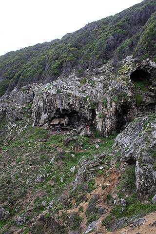
Blombos Cave is an archaeological site located in Blombos Private Nature Reserve, about 300 km east of Cape Town on the Southern Cape coastline, South Africa. The cave contains Middle Stone Age (MSA) deposits currently dated at between c. 100,000 and 70,000 years Before Present (BP), and a Late Stone Age sequence dated at between 2000 and 300 years BP. The cave site was first excavated in 1991 and field work has been conducted there on a regular basis since 1997, and is ongoing.

The Karoo Supergroup is the most widespread stratigraphic unit in Africa south of the Kalahari Desert. The supergroup consists of a sequence of units, mostly of nonmarine origin, deposited between the Late Carboniferous and Early Jurassic, a period of about 120 million years.

Helderberg refers to a planning district of the City of Cape Town metropolitan municipality, the mountain after which it is named, a wine-producing area in the Western Cape province of South Africa, or a small census area in Somerset West.

Mowbray is one of the Southern Suburbs of Cape Town, South Africa and lies on the slopes of Devil's Peak. Mowbray is at a junction of several major Cape Town highways and has an important multi-modal public transport interchange at Mowbray railway station. Its original name was Driekoppen.

In climatology, the 8.2-kiloyear event was a sudden decrease in global temperatures that occurred approximately 8,200 years before the present, or c. 6,200 BC, and which lasted for the next two to four centuries. It defines the start of the Northgrippian age in the Holocene epoch. The cooling was significantly less pronounced than during the Younger Dryas cold period that preceded the beginning of the Holocene. During the event, atmospheric methane concentration decreased by 80 ppb, an emission reduction of 15%, by cooling and drying at a hemispheric scale.

The Subboreal is a climatic period, immediately before the present one, of the Holocene. It lasted from 3710 to 450 BCE.
The Glaciogenic Reservoir Analogue Studies Project (GRASP) is a research group studying the subglacial to proglacial record of Pleistocene glacial events. It is based in the Delft University of Technology.
Wonderwerk Cave is an archaeological site, formed originally as an ancient solution cavity in dolomite rocks of the Kuruman Hills, situated between Danielskuil and Kuruman in the Northern Cape Province, South Africa. It is a National Heritage Site, managed as a satellite of the McGregor Museum in Kimberley. Geologically, hillside erosion exposed the northern end of the cavity, which extends horizontally for about 140 m (460 ft) into the base of a hill. Accumulated deposits inside the cave, up to 7 m (23 ft) in-depth, reflect natural sedimentation processes such as water and wind deposition as well as the activities of animals, birds, and human ancestors over some 2 million years. The site has been studied and excavated by archaeologists since the 1940s and research here generates important insights into human history in the subcontinent of Southern Africa. Evidence within Wonderwerk cave has been called the oldest controlled fire. Wonderwerk means "miracle" in the Afrikaans language.

Border Cave is an archaeological site located in the western Lebombo Mountains in Kwazulu-Natal. The rock shelter has one of the longest archaeological records in southern Africa, which spans from the Middle Stone Age to the Iron Age.

Middle Prong Wilderness was designated in 1984 and it covers 7,900 acres (32 km2) within the Pisgah National Forest in Haywood County, Western North Carolina. The Wilderness Area spans steep, rugged high-elevation ridges ranging from 3,200 to over 6,400 feet, and the area gets its name from the Middle Prong of the Pigeon River finding whose headwaters are located in the area. NC 215 separates from Shining Rock Wilderness to the northeast.
Elands Bay Cave is located near the mouth of the Verlorenvlei estuary on the Atlantic coast of South Africa's Western Cape Province. The climate has continuously become drier since the habitation of hunter-gatherers in the Later Pleistocene. The archaeological remains recovered from previous excavations at Elands Bay Cave have been studied to help answer questions regarding the relationship of people and their landscape, the role of climate change that could have determined or influenced subsistence changes, and the impact of pastoralism and agriculture on hunter-gatherer communities.
Boomplaas Cave is located in the Cango Valley in the foothills of the Swartberg mountain range, north of Oudtshoorn, Eden District Municipality in the Western Cape Province, South Africa. It has a 5 m (16 ft) deep stratified archaeological sequence of human presence, occupation and hunter-gatherer/herder acculturation that might date back as far as 80,000 years. The site's documentation contributed to the reconstruction of palaeo-environments in the context of changes in climate within periods of the Late Pleistocene and the Holocene. The cave has served multiple functions during its occupation, such as a kraal (enclosure) for animals, a place for the storage of oil rich fruits and as a hunting camp. Circular stone hearths and calcified dung remains of domesticated sheep as well as stone adzes and pottery art were excavated indicating that humans lived at the site and kept animals.

The Whitehill Formation, alternatively written as White Hill Formation and formerly known as White Band or Whitehill or White Hill Member, is a regional Early Permian geologic formation belonging to the Ecca Group in the southeastern ǁKaras Region of southeastern Namibia and Eastern, Northern and Western Cape provinces of South Africa.
The Bundu Farm site is a kidney shape depression of land located in the Bushmanland region of Northern Cape, South Africa. The excavations at this site during 1998-2003 had unearthed a sequence of archaeological remains including Earlier, Middle and Later Stone Age assemblages and preserved fauna. These discoveries give an insight into the occupation of the Bushmanland prehistoric people and possible connection of cultures and traditions between the central interior and the West coast of South Africa.

The history of Southern Africa has been divided into its prehistory, its ancient history, the major polities flourishing, the colonial period, and the post-colonial period, in which the current nations were formed. Southern Africa is bordered by Central Africa, East Africa, the Atlantic Ocean, the Indian Ocean, and the Sahara Desert. Colonial boundaries are reflected in the modern boundaries between contemporary Southern African states, cutting across ethnic and cultural lines, often dividing single ethnic groups between two or more states.


