
Brampton is a city in the Canadian province of Ontario. It is part of the Greater Toronto Area (GTA) and is a lower-tier municipality within Peel Region. The city has a population of 656,480 as of the 2021 Census, making it the ninth most populous municipality in Canada and the third most populous city in the Greater Golden Horseshoe urban area, behind Toronto and Mississauga.

Caledon is a town in the Regional Municipality of Peel in the Greater Toronto Area of Ontario, Canada. The name comes from a shortened form of Caledonia, the Roman name for what is now Scotland. Caledon is primarily rural with a number of hamlets and small villages, but also contains the larger community of Bolton in its southeastern quadrant, adjacent to York Region. Some spillover urbanization also occurs in the south bordering the City of Brampton.
King's Highway 407, commonly referred to as Highway 407 and colloquially as the "four-oh-seven", is a tolled 400-series highway in the Canadian province of Ontario. Comprising a privately leased segment as well as a publicly owned segment, the route spans the entire Greater Toronto Area (GTA) around the city of Toronto, travelling through the suburbs of Burlington, Oakville, Mississauga, Brampton, Vaughan, Markham, Pickering, Whitby, and Oshawa before ending in Clarington, north of Orono. At 151.4 km long, this is the fourth-longest freeway in Ontario's 400 series network, after Highways 417, 400, and 401. The segment between Burlington and Brougham in Pickering is leased to and operated by the 407 ETR Concession Company Limited and is officially known as the 407 Express Toll Route (407 ETR). It begins at the junction of the Queen Elizabeth Way (QEW) and Highway 403 in Burlington, and travels 108.0 km (67.1 mi) across the GTA to Brock Road in Pickering. East of Brock Road, the tollway continues east as Highway 407, a toll route operated by the provincial government, for 43.4 km (27.0 mi) to Highway 35/115 in Clarington. The route interchanges with nine freeways: the QEW, Highway 403, Highway 401, Highway 410, Highway 427, Highway 400, Highway 404, Highway 412, and Highway 418. Highway 407 is an electronically operated toll highway; there are no toll booths along the length of the route. Distances are calculated automatically using transponders or automatic number-plate recognition, which are scanned at entrance and exit portals.

The Regional Municipality of Peel is a regional municipality in the Greater Toronto Area, Southern Ontario, Canada. It consists of three municipalities to the west and northwest of the city of Toronto: the cities of Mississauga and Brampton, and the town of Caledon, each of which spans its full east–west width. The regional seat is in Brampton.
King's Highway 7, commonly referred to as Highway 7 and historically as the Northern Highway, is a provincially maintained highway in the Canadian province of Ontario. At its peak, Highway 7 measured 716 km (445 mi) in length, stretching from Highway 40 east of Sarnia in Southwestern Ontario to Highway 17 west of Ottawa in Eastern Ontario. However, due in part to the construction of Highways 402 and 407, the province transferred the sections of Highway 7 west of London and through the Greater Toronto Area to county and regional jurisdiction. The highway is now 535.7 km (332.9 mi) long; the western segment begins at Highway 4 north of London and extends 154.1 km (95.8 mi) to Georgetown, while the eastern segment begins at Donald Cousens Parkway in Markham and extends 381.6 km (237.1 mi) to Highway 417 in Ottawa.

Finch Avenue is an arterial thoroughfare that travels east–west in Toronto, Ontario, Canada. The road continues west into the Regional Municipality of Peel as Regional Road 2 and east into the Regional Municipality of Durham as Regional Road 37.

The Credit River is a river in southern Ontario, which flows from headwaters above the Niagara Escarpment near Orangeville and Caledon East to empty into Lake Ontario at Port Credit, Mississauga. It drains an area of approximately 1,000 square kilometres (390 sq mi). The total length of the river and its tributary streams is over 1,500 kilometres (930 mi).
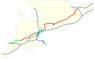
King's Highway 410, also known as Highway 410 and colloquially as the four-ten, is a 400-series highway in the Canadian province of Ontario that connects Highways 401 and 403 to Brampton. North of Brampton, the commuter freeway ends and the route becomes Highway 10, which continues north through Caledon as a four-lane undivided highway. The route is patrolled by the Ontario Provincial Police and has a speed limit of 100 km/h (62 mph).

Steeles Avenue is an east–west street that forms the northern city limit of Toronto and the southern limit of York Region in Ontario, Canada. It stretches 77.3 km (48.0 mi) across the western and central Greater Toronto Area from Appleby Line in Milton in the west to the Toronto-Pickering city limits in the east, where it continues east into Durham Region as Taunton Road, which itself extends 58 km (36 mi) across the length of Durham Region to its boundary with Northumberland County.

Hurontario Street is a roadway running in Ontario, Canada between Lake Ontario at Mississauga and Lake Huron's Georgian Bay at Collingwood. Within Peel Region, it is a major urban thoroughfare within the cities of Mississauga and Brampton, which serves as the divide from which cross-streets are split into East and West, except at its foot in the historic Mississauga neighbourhood of Port Credit. Farther north, with the exception of the section through Simcoe County, where it forms the 8th Concession, it is the meridian for the rural municipalities it passes through. In Dufferin County, for instance, parallel roads are labelled as EHS or WHS for East of Hurontario Street.
King's Highway 5, commonly referred to as Highway 5 and historically as the Dundas Highway and Governor's Road, is a provincially maintained highway in the Canadian province of Ontario. The east–west highway travels a distance of 12.7 km (7.9 mi) between Highway 8 at Peters Corners, north of Hamilton, and Highway 6 at Clappison's Corners. Prior to several sections being downloaded to the municipalities in which they were located, Highway 5 served as bypass to Highway 2, connecting with it in both Paris and Toronto, a distance of 114.3 km (71.0 mi).

The Toronto Purchase was the sale of lands in the Toronto area from the Mississaugas of New Credit to the British crown. An initial, disputed, agreement was made in 1787, in exchange for various items. The agreement was revisited in 1805, intended to clarify the area purchased. The agreement remained in dispute for over 200 years until 2010, when a settlement for the land was made between the Government of Canada and the Mississaugas for the land and other lands in the area.

The CN Halton Subdivision is a major railway line in Southern Ontario, Canada. It is owned and operated by the Canadian National Railway (CN).
King's Highway 136, commonly referred to as Highway 136, was a provincially maintained highway in the Canadian province of Ontario that connected former Highway 24 near Caledon with Highway 9 in Orangeville. The majority of the route was located in the Regional Municipality of Peel; however, the section in Orangeville was in Dufferin County. The route of Highway 136 was originally part of Highway 24; it was created in 1962 when Highway 24 was rerouted along Highway 51. The highway remained unchanged until 1997, when it was transferred to the Regional Municipality of Peel and the Town of Orangeville.

GO Transit bus services are provided throughout the Greater Toronto and Hamilton Area (GTHA) and the Greater Golden Horseshoe. In 2023, the system had a ridership of 15,229,800.
King's Highway 413, known as the GTA West Corridor or GTA West until 2021, is a proposed 400-series highway and bus transitway in the western Greater Toronto Area of the Canadian province of Ontario. The approximately 52-kilometre (32 mi) route is currently undergoing planning and analysis under an environmental impact assessment (EA) by the Ministry of Transportation of Ontario (MTO) and the Government of Ontario. If approved, a new four-to-six lane controlled-access highway would be built between the existing interchange of Highway 401 and the 407 ETR at the Halton–Peel boundary, and Highway 400 north of Vaughan. In addition, two new extensions would be built to connect Highway 410 and Highway 427 with Highway 413.

Burnhamthorpe Road is a major arterial road in the cities of Toronto and Mississauga, Ontario; beginning at Dundas Street, near Islington Avenue, running west and becoming a rural road in the Town of Oakville, where it terminates at Tremaine Road, where it changes name.

The transport infrastructure and services in the Canadian city of Mississauga, Ontario include provincial highways and municipal roads, passenger and freight rail, regional and municipal bus service, and an international airport. It is interconnected with air, road, and rail transportation networks spanning the Greater Toronto Area and beyond.


