Århusgade

Last updated
Århusgade
Arhusgade 03.JPG
Århusgade
Length 1,250 m (4,100 ft)
Location Copenhagen, Denmark
Postal code 2100
Coordinates 55°42′23.76″N12°35′6″E / 55.7066000°N 12.58500°E / 55.7066000; 12.58500

Århusgade is a street in the Østerbro district of Copenhagen, Denmark. It extends east from Østerbrogade and passes under the railway just before entering the southernmost part of Nordhavn which is known as the Århusgade neighbourhood (Danish Århusgadekvarteret) after it. The street has many cafés and small shops. The street is named after the City of Aarhus, the second largest city in Denmark.

Østerbro district of Copenhagen

Østerbro is one of the 10 official districts of Copenhagen, Denmark. It is located just north of the city centre, outside the old city gate Østerport which, after it was moved around 1700, used to be located close to present-day Østerport Station. From the beginning, Østerbro has been a wealthy district, and it remains one of the most affluent areas in Copenhagen.

Copenhagen Capital of Denmark

Copenhagen is the capital and most populous city of Denmark. As of July 2018, the city has a population of 777,218. It forms the core of the wider urban area of Copenhagen and the Copenhagen metropolitan area. Copenhagen is situated on the eastern coast of the island of Zealand; another small portion of the city is located on Amager, and is separated from Malmö, Sweden, by the strait of Øresund. The Øresund Bridge connects the two cities by rail and road.

Denmark constitutional monarchy in Europe

Denmark, officially the Kingdom of Denmark, is a Nordic country and the southernmost of the Scandinavian nations. Denmark lies southwest of Sweden and south of Norway, and is bordered to the south by Germany. The Kingdom of Denmark also comprises two autonomous constituent countries in the North Atlantic Ocean: the Faroe Islands and Greenland. Denmark proper consists of a peninsula, Jutland, and an archipelago of 443 named islands, with the largest being Zealand, Funen and the North Jutlandic Island. The islands are characterised by flat, arable land and sandy coasts, low elevation and a temperate climate. Denmark has a total area of 42,924 km2 (16,573 sq mi), land area of 42,394 km2 (16,368 sq mi), and the total area including Greenland and the Faroe Islands is 2,210,579 km2 (853,509 sq mi), and a population of 5.8 million.

Contents

History

Ny Kalkbraenderi Ny Kalkbraenderi.jpg
Ny Kalkbrænderi

Århusgade crosses an area which was known as Slagtervangen until the second half of the 19th century. The area was owned by the City of Copenhagen but leased to the Butchers' Guild who used it for grazing. The street also passes the site where Ny Kalkbrænderi ("The New Lime Plant") was built in 1777. It occupied the triangular site between present day Løgstørgade )then Kalkbrænderivej, "Lime Plant Road"(, Strandboulevarden and Århusgade. [1]

In the 1870s, the wine merchant Hans Just built a summer residence near the coast. In 1882, together with other investors, he established a distillery, Fortuna, on the neighbouring site. The oldest section of Århusgade, then named Fortunavej ("Fortuna Road"), was created in 1885 when they wanted a more direct link between their factory and Østerbrogade. [1]

The name Århusgade was introduced in 1886 when a large number of streets in the area were named after larger Danish towns. The man behind the naming scheme was Thorkild Krak. The street was built over with apartments for the many workers at enterprises such as the Øresund cryolite factory and Copenhagen's new Freeport which opened in 1894.

Freeport of Copenhagen

The Free Port of Copenhagen is a bonded area in the northern part of Harbour of Copenhagen, Denmark. Created to consolidate Copenhagen's position as an important maritime hub in Northern Europe, it was established in the area just north of the fortress Kastellet and later expanded northwards several times. The original grounds, now known as Søndre Frihavn, has since been released for other uses. It comprised Amerika Plads, a modern mixed-use development, America Quay, India Quay, Langelinie and Marble Pier, the four quays which bounded the harbour, and Midtermolen, a pier which divides it into an east and west basin.

Notable buildings and residents

No. 101: The former tramway depot, nor Osterbrohuset Arhusgade Remise.JPG
No. 101: The former tramway depot, nor Østerbrohuset
The Hans Just Warehouse at No. 88 Hans Just Pakhus.JPG
The Hans Just Warehouse at No. 88

Østerbrohuset (No. 101) is a community centre with sport facilities, mainly used for badminton and basketball, a small café and facilities for local associations. The building is a former tramway depot, Århusgade Remise, built in 1901 to design by Vilhelm Friederichsen for De Kjøbenhavnske Sporveje ("Copenhagen Tramways"). The building is now used as a community centre with sport facilities, mainly used for badminton and basketball, a small café and facilities for local associations.

The Hans Just Warehouse (Hans Just Pakhus) was built in 1917 by Hans Just's son Poul Just. With its nine floors, it was the building in Denmark with most floors at the time of its completion. The building is still owned by the family and serves as headquarters of Hans Just A/S as well as their property company Karberghus.

The Hans Just Group is a distributor of wine and alcohol in the Nordic countries. The group consists of Hans Just A/S in Denmark, Nigab AB in Sweden, Robert Prizelius AS in Norway, Beverage Partners Finland OY in Finland and BJC Distribution Z O.O. in Poland.

Århusgadekvarteret redevelopment

The former headquarters of Russian Danish Trading Company Russisk Handelskompagni.JPG
The former headquarters of Russian Danish Trading Company

The Århusgade neighbourhood is the first phase of the redevelopment of Copenhagen's northern docklands. The area is covered by two local plans. A local plan for the eastern part of the Århusgade neighbourhood was adopted in 2011. [2] Another local plan covers the area closest the rail line. [3]

The area will be home to 2,400 residents and 1,700 jobs. [2] The area will consist of a mixture of new and old buildings. The first residents moved into their new apartments in Havnehuset in April 2015. Historic buildings include the former headquarters of Russisk Dansk Handelskompagni ("Russian Danish Trading Company") from 1918. The red, Neo-Baroque building was later taken over by Riffelsyndikatet and is now part of a larger, five-winged complex on the corner with Billedgade.

Århusgade will be the main shopping street of the neighbourhood. Its retail and restaurant premises will be developed in a 60/40 partnership between Nordic Real Estate Partners and By & Havn. [4]

Transport

Nordhavn station is located just south of the intersection with Kalkbrænderihavnsvej. It is served by the A, B, E, G and H trains of the S-train network. The Nordhavn Line of the Copenhagen Metro will have a station in the Århusgade neighbourhood. The western end of the street is located 700 metres to the north of the future City Circle Line station at Trianglen.

Related Research Articles

Nordhavn, Copenhagen northern harbor of Copenhagen, Denmark

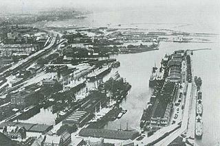
Nordhavnen, or Nordhavn, is a harbour area at the coast of the Øresund, founded at the end of the 19th century in Copenhagen, Denmark. It covers an area of more than 2 km².

Hellerup town in Region Hovedstaden, Gentofte Municipality, Denmark

Hellerup is a district of Gentofte Municipality in the suburbs of Copenhagen, Denmark. The most urban part of the district is centred on Strandvejen and is bordered by Østerbro to the south and the Øresund to the east. It comprises Tuborg Havn, the redeveloped brewery site of Tuborg Breweries, with the Waterfront Shopping Center, a marina and the headquarters of several large companies. Other parts of the district consist of single family detached homes. Local landmarks include the science centre Experimentarium and the art Øregaard Museum.

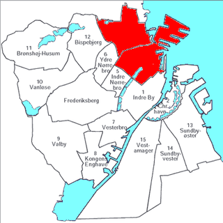
Districts of Copenhagen are often based on informal designations based on historic origins, often with alternative names and loosely defined boundaries. Copenhagen Municipality is divided into 10 official administrative districts but they often comprise areas of a heterogeneous character which are colegually not seen as one district. Some districts have earlier been official subdivisions and thus have semi-official boundaries. Copenhagen postal code designations often correspond to district boundaries but in some cases differ from them, as an example parts of the city centre has the postal code København V which is generally associated with Vesterbro.

Østerbrogade street in Copenhagen

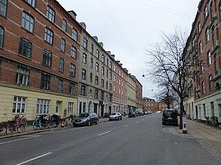
Østerbrogade is the principal shopping street and thoroughfare in the Østerbro district of Copenhagen, Denmark. It extends from Lille Triangel at the north-eastern tip of The Lakes, passes Trianglen, and continues to Svanemøllen station from where it becomes Strandvejen.

Svanemølle Beach

Svanemølle Beach is an urban beach situated in the Østerbro district of Copenhagen, Denmark. It is situated in the bottom of the Svanemølle Bay, off Strandpromenaden, a promenade that follows the coast between Copenhagen's Nordhavn area to the south and Tuborg Havn in Hellerup to the north. Svanemøllen Marina and the Svanemølle Power Station are located just south of the beach.

St. Jamess Church, Copenhagen Church in Copenhagen, Denmark

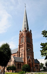
St. James's Church in the Østerbro district of Copenhagen, Denmark, was the first church to be built in the district. It was designed by Ludvig Fenger in a Neo-Gothic style and built between 1876 and 1878.

Amerika Plads

Amerika Plads is a public square and surrounding neighbourhood in the Østerbro district of Copenhagen, Denmark. It is the result of a redevelopment of an area in the southern part of the former Freeport of Copenhagen into a mixed-use neighbourhood which consists of dwellings, offices and retail establishments, combining converted historic buildings and modern architecture. The former Free Port Station building was put in storage during the redevelopment and is now located in the middle of the square where it serves as a café. The area is to the west bounded by Kalkbrænderihavnsgade, part of a major thoroughfare, and to the east by Dampfærgevej connected to Kalkbrænderihavnsgade in both ends and separating Amerika Plads from America Quay, the western quay of the Southern Free Port dock. The name of the area, like that of the quay, is a reference to the large passenger ships which used to transport Danish emigrants to New York City during the first half of the 20th century.

Østerfælled Barracks

Østerfælled Barracks, later known as Østerbrogade Kaserne, was a barracks originally built in the 1890s for the Guard Hussars of the Royal Danish Army in the emerging Østerbro district of Copenhagen, Denmark. Its grounds have now been transformed into a mixed-use development surrounding a pedestrian zone and is now known as Østerfælled Torv. Many of the old buildings have been retained while others have been demolished to make way for new residential buildings. The old main entrance to the barracks is located on the corner of Østerbrogade and Gunner Nu Hansens Plads.

Østerfælled Torv

Østerfælled Torv is a mixed-use development surrounding a public space by the same name in the former grounds of Østerfælled Barracks in the Østerbro district of Copenhagen, Denmark. It is a result of a redevelopment of the site in the 1990s which preserved many of the old buildings, now used for retail and commercial space as well as cultural facilities, combining them with new apartment buildings.

Sankt Jakobs Plads public square in the Østerbro district of Copenhagen, Denmark

Sankt Jakobs Plads is a public square located off the east side of Østerbrogade in the Østerbro district of Copenhagen, Denmark. It takes its name after St. James' Church on the other side of the street.

Ryesgade street in Copenhagen

Ryesgade is a street straddling the border of the Nørrebro and Østerbro districts of Copenhagen, Denmark. Together with Ravnsborggade, its continuation to the south, it forms the backbone of a small neighbourhood bounded by The Lakes to the east, Blegdamsvej to the west, Nørrebrogade to the south and Østerbrogade to the north. The busy artery Fredensgade and Fredens Park, a narrow green space which runs along its northside, effectively separates the Nørrebro and Østerbro portions of Ryesgade from each other. Ryesgade was formerly known for its many second-hand stores of which a few still exist today.

Zions Church, Copenhagen Church in Copenhagen, Denmark

Zion's Church is a Lutheran church on Østerbrogade, just south of Svanemøllen station, in the Østerbro district of Copenhagen, Denmark. It was completed in 1896 to a design by Valdemar Koch, making it the second oldest church in Østerbro.

Øster Allé street in Copenhagen

Øster Allé is a street in the Østerbro district of Copenhagen, Denmark, connecting Trianglen to Vibenhus Runddel. The northern part of the street, after Parken Stadium, Denmark's national football stadium, bisects Fælledparken, Copenhagen's largest park.

Trianglen, Copenhagen square in Copenhagen

Trianglen is a central junction and public space in the Østerbro district of Copenhagen, Denmark. Five streets meet in the junction: Blegdamsvej, Øster Allé, Østerbrogade, Nordre Frihavnsgade and Odensegade. Trianglen will be a station on the City Circle Line of the Copenhagen Metro.

Strandboulevarden street in Copenhagen

Strandboulevarden is a major street in the Østerbro district of Copenhagen, Denmark. It runs from Fridtjof Nansens Plads as in the south to Østerbrogade in the north, linking Kristianiagade with Jagtvej.

Østbanegade street in Copenhagen

Østbanegade is a street in Copenhagen, Denmark. It begins at Østerport Station on Oslo Plads and continues north along the west side of the railway tracks for about 2 kilometres to Aarhusgade where an underpass connects the street to the other side of the railway line. A second underpass is situated at Nordre Frihavnsgade, just south of Nordhavn station, while a foot and cycle bridge is found at Mandalsgade near the beginning of the street.

Nordre Frihavnsgade street in Copenhagen

Nordre Frihavnsgade is a street in the Østerbro district of Copenhagen, Denmark, linking the junction Trianglen in the southwest with Østbanegade In the northeast. The street passes the two small squares Victor Borges Plads and Melchiors Plads. An underpass under the raised railway tracks at the end of the street provides access to Nordhavn's Århusgade neighbourhood.

Gunnar Nu Hansens Plads

Gunnar Nu Hansens Plads is a public space in the Østerbro district of Copenhagen, Denmark. It consists of a triangular plaza, located on the west side of Østerbrogade, just north of Parken Stadium, which turns into a wide street and continues for about 200 m to Fælledparken, The street then continues southwest as Per Henrik Lings Allé to Øster Allé. Several sports venues, some of which are listed, are located on the south side of the square. The former Østerfælled Barracks, now a mixed-use development known as Østerfælled Torv, are located on its north side.

Emdrup

Emdrup is a neighbourhood straddling the border between the Bispebjerg and Østerbro district of Copenhagen, Denmark. It is located between Utterslev Mose in the west and the Helsingør Motorway in the east, just south of the border with Gladsaxe and Gentofte municipalities. Emdrup is a mainly residential neighbourhood, boasting a combination of apartment buildings and areas with single-family detached home. Emdrup station is located on the Farum radial of the S-train system. AU Campus Emdrup, Aarhus University's Copenhagen campus, is situated just north of the station. The most important greenspaces are Lake Emdrup with its small lakeside park in the east, Utterslev Mose in the west and Emdrupparken with sport facilities in the north.

References

  1. 1 2 "Steder på Østerbro". dengang.dk (in Danish). Retrieved 27 May 2015.
  2. 1 2 "Lokalplan for Århusgadekvarteret Vest". Byens Ejendomme (in Danish). Retrieved 27 May 2015.
  3. "Byggeprojekter for 13 milliarder igangsættes på Nordhavnen". By & Havn (in Danish). Retrieved 27 May 2015.
  4. "Københavns Nordhavn får nyt butiksstrøg". Building Supply (in Danish). Retrieved 27 May 2015.

Coordinates: 55°42′24″N12°35′06″E / 55.7066°N 12.5850°E / 55.7066; 12.5850