
Indre Østerbro, was one of the administrative, statistical, and tax city districts ("bydele") comprising the municipality of Copenhagen, Denmark. It lay on the eastern edge of the municipality. It covered an area of 6.76 km2, had a population of 46,095 and a population density of 6,817 per km2. Since 2007, the district has been part of the administrative district Østerbro.
Ydre Østerbro is an area in Copenhagen, Denmark. It is the part of the district of Østerbro located farthest from the City Centre. It lies on the northeast border of the municipality. It covers an area of 5.08 km2, has a population of 35,937 and a population density of 7,081 per km2.
Ydre Nørrebro is an area in Copenhagen, Denmark. It is the part of the district of Nørrebro located farthest from the City Centre. It covers an area of 2.10 km², has a population of 41,497 and a population density of 19,733 per km², making it the most densely populated district in Copenhagen and all of Denmark. Approximately 25% of the inhabitants are immigrants, in some areas the immigrants population is 50%. Many shops are run by Middle Eastern and South Asian immigrants which gives the area a very multi-ethnic atmosphere.

Vesterbro is one of the 15 administrative, statistical, and city tax districts (bydele) comprising the municipality of Copenhagen, Denmark. It covers an area of 3.76 km2 (1.45 sq mi), and has a population of 51,466 and a population density of 13,688 per km2.
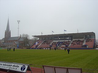
Østerbro Stadium is a combined football and athletics stadium in Copenhagen, Denmark. It is the home of the football clubs Boldklubben af 1893 and BK Skjold and it is also the home stadium of the athletics clubs Københavns Idræts Forening and Sparta. It has a capacity of approximately 4,400. The stadium is currently being renovated, to meet the demands from the Danish Football Association. The field will be made both longer and wider and a new track will be laid for track and field. The stadium was used for the 2009 World Outgames.

Nordhavnen, or Nordhavn, is a harbour area at the coast of the Øresund, founded at the end of the 19th century in Copenhagen, Denmark. It covers an area of more than 2 km2.

Østerbrogade is the principal shopping street and thoroughfare in the Østerbro district of Copenhagen, Denmark. It extends from Lille Triangel at the north-eastern tip of The Lakes, passes Trianglen, and continues to Svanemøllen station from where it becomes Strandvejen.

Svanemølle Beach is an urban beach situated in the Østerbro district of Copenhagen, Denmark. It is situated in the bottom of the Svanemølle Bay, off Strandpromenaden, a promenade that follows the coast between Copenhagen's Nordhavn area to the south and Tuborg Havn in Hellerup to the north. Svanemøllen Marina and the Svanemølle Power Station are located just south of the beach.

Victor Borges Plads is a public square in the Østerbro district of Copenhagen, Denmark.

Amerika Plads is a public square and surrounding neighbourhood in the Østerbro district of Copenhagen, Denmark. It is the result of a redevelopment of an area in the southern part of the former Freeport of Copenhagen into a mixed-use neighbourhood which consists of dwellings, offices and retail establishments, combining converted historic buildings and modern architecture. The former Free Port Station building was put in storage during the redevelopment and is now located in the middle of the square where it serves as a café. The area is to the west bounded by Kalkbrænderihavnsgade, part of a major thoroughfare, and to the east by Dampfærgevej connected to Kalkbrænderihavnsgade in both ends and separating Amerika Plads from America Quay, the western quay of the Southern Free Port dock. The name of the area, like that of the quay, is a reference to the Amerikabåten, large passenger ships which used to transport Danish emigrants to New York City during the first half of the 20th century.

The Boulevard Line is a 3.2-kilometer (2.0 mi) long partly underground railway between Copenhagen Central Station and Østerport Station in Copenhagen, Denmark. The quadruple track railway carries today one dual track for the Copenhagen S-train system and another dual track for the mainline railway and regional trains. The line has two intermediate stations, Vesterport Station and Nørreport Station. It continues above ground to Nordhavn station and at Svanemøllen station the tracks separate towards either Ryparken station or Hellerup station. Dybbølsbro station is also located along this railway, located just a bit south of Copenhagen Central. Out of the four main S-train branches, three follow this path, between Dybbølsbro and Svanemøllen. Only at Copenhagen Central, Nørreport and Østerport do all trains stop. While Dybbølsbro, Vesterport, Nordhavn and Svanemøllen all are S-train stations only..

Blegdamsvej is a street in Copenhagen, Denmark, connecting Sankt Hans Torv in Nørrebro to Trianglen in Østerbro. The busy artery Fredensgade separates the Nørrebro and Østerbro sections of the street from each other. The north side of the street is dominated by the Panum Building and Rigshospitalet, located on either side of Tagensvej.

Øster Allé is a street in the Østerbro district of Copenhagen, Denmark, connecting Trianglen to Vibenhus Runddel. The northern part of the street, after Parken Stadium, Denmark's national football stadium, bisects Fælledparken, Copenhagen's largest park.

Østbanegade is a street in Copenhagen, Denmark. It begins at Østerport Station on Oslo Plads and continues north along the west side of the railway tracks for about 2 kilometres to Aarhusgade where an underpass connects the street to the other side of the railway line. A second underpass is situated at Nordre Frihavnsgade, just south of Nordhavn station, while a foot and cycle bridge is found at Mandalsgade near the beginning of the street.
Jotaučiai Manor was a former residential manor in Jotaučiai village, Utena District Municipality, Lithuania.
Århusgade is a street in the Østerbro district of Copenhagen, Denmark. It extends east from Østerbrogade and passes under the railway just before entering the southernmost part of Nordhavn which is known as the Århusgade neighbourhood after it. The street has many cafés and small shops. The street is named after the City of Aarhus, the second largest city in Denmark.

Randersgade is a street in the Østerbro district of Copenhagen, Denmark, linking Nordre Frihavnsgade in the south to Strandboulevarden in the north. The small square Bopas Plads is located on the corner of Randersgade with Viborggade.

Nordre Frihavnsgade is a street in the Østerbro district of Copenhagen, Denmark, linking the junction Trianglen in the southwest with Østbanegade In the northeast. The street passes the two small squares Victor Borges Plads and Melchiors Plads. An underpass under the raised railway tracks at the end of the street provides access to Nordhavn's Århusgade neighbourhood.
The North Campus is one of the University of Copenhagen's four campuses in Copenhagen, Denmark. It is situated just north of the city centre, across from Copenhagen's largest park, Fælledparken, and between the Østerbro and Nørrebro districts. It is home to the Faculty of Science and the Faculty of Health and Medical Sciences.
Nørre Alle is a street in Copenhagen, Denmark, running from Blegdamsvej in Nørrebro in the south to Vibenshus Runddel in Østerbro in the north. It runs through University of Copenhagen's North Campus which is centred on its junction with Tagensvej. The section north of the junction, which separates Fælledparken to the east from the University Park to the west, is a busy artery. De Gamles By is situated on the west side of the more quiet, western portion.
