Nørrebro is one of the 10 official districts of Copenhagen, Denmark. It is northwest of the city centre, beyond the location of the old Northern Gate (Nørreport), which, until dismantled in 1856, was near the current Nørreport station.

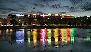
Indre By, also known as Copenhagen Center or K or Downtown Copenhagen, is an administrative district (by) in central Copenhagen, the capital of Denmark. It covers an area of 4.65 square kilometres (1.80 sq mi), has a population of 26,223, and a population density of 5,638 per km².

Indre Østerbro, is one of the 15 administrative, statistical, and tax city districts ("bydele") comprising the municipality of Copenhagen, Denmark. It lies on the eastern edge of the municipality. It covers an area of 6.76 km², has a population of 46,095 and a population density of 6,817 per km².

Indre Nørrebro, is one of the 15 administrative, statistical, and tax city districts (bydele) comprising the municipality of Copenhagen, Denmark. It covers an area of 1.72 km², has a population of 31,046 and a population density of 18,057 per km², making it the second most densely populated district in Copenhagen.

Vesterbro is one of the 15 administrative, statistical, and city tax districts (bydele) comprising the municipality of Copenhagen, Denmark. It covers an area of 3.76 km², and has a population of 51,466 and a population density of 13,688 per km².

Kongens Enghave, commonly known as Sydhavnen or the postal district of 2450 Copenhagen SV (southwest) is a district in southern Copenhagen. While its core is a largely pre-WWII former working class district, it also contains an upscale residential area along the harbour having been developed after 2000, scattered industrial areas, large parks such as Valbyparken and Sydhavnstippen, allotment gardens and parts of Vestre Kirkegård, the city's largest cemetery.

The City Circle Line or M3 is a loop line of the Copenhagen Metro. It has been claimed by COWI A/S that the City Circle Line is the largest construction project to have taken place in Copenhagen during the last 400 years. The network's total length is 15.5 kilometres (9.6 mi) and has 17 stations. The line opened on 29 September 2019.

Islands Brygge is a harbourfront area in central Copenhagen, Denmark, located on the north-western coast of Amager. The neighbourhood is noted for its waterfront park Havneparken, which is one of the most popular areas along the Copenhagen harbourfront and the location of one of the Copenhagen Harbour Baths.

Copenhagen Municipality, also known in English as the Municipality of Copenhagen, located in the Capital Region of Denmark, is the largest of the four municipalities that constitute the City of Copenhagen, the other three being Dragør, Frederiksberg, and Tårnby. The Municipality of Copenhagen constitutes the historical city centre and the majority of its landmarks. It is the most populous in the country with a population of 638,678 inhabitants, and covers 86.4 square kilometres (33.4 sq mi) in area,. Copenhagen Municipality is located at the Zealand and Amager islands and totally surrounds Frederiksberg Municipality on all sides. The strait of Øresund lies to the east. The city of Copenhagen has grown far beyond the municipal boundaries from 1901, when Frederiksberg Municipality was made an enclave within Copenhagen Municipality. Frederiksberg has the largest population density of the municipalities of Denmark.

Bryggebroen is one of the new bicycle/pedestrian bridges in Copenhagen inner harbour and is a 190 metres (620 ft) combined pedestrian and bicyclist bridge directed east-west. The bridge is joined to Kalvebod Brygge and Cykelslangen bridge (west) and Islands Brygge (east) and thus connects Vesterbro on Zealand and Amager. The bridge has become a popular place for attaching love padlocks.
Amager Øst is one of the 10 official districts of Copenhagen, Denmark. It encompasses the part of Copenhagen located on the island of Amager, east of the major shopping street Amagerbrogade.Prior to an administrative reform in 2006-08, the district was known as Sundbyøster.

St. Paul's Church is a Lutheran church in central Copenhagen, Denmark, also colloquially known as Nyboder's Church due to its location in the middle of the Nyboder area. It was designed by Johannes Emil Gnudtzmann and constructed from 1872 to 1877.
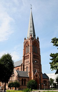
St. James's Church in the Østerbro district of Copenhagen, Denmark, was the first church to be built in the district. It was designed by Ludvig Fenger in a Neo-Gothic style and built between 1876 and 1878.
Nordvest or The North West Block is an area in Denmark's Copenhagen municipality. It is located in the southwestern part of the Bispebjerg district. Although there are no clear borders nor any official demarcation, it is broadly recognized as the area covered mostly by the Danish postal code 2400 København NV, although some areas lie outside this postal code. As of 2005, 44,177 people resided in the area.

An urban district is the name used for urban or municipality districts in some of the larger municipalities of Denmark. The term is not strictly defined, but is usually bigger than a quarter or a city block.

The South Campus is one of University of Copenhagen's four campuses in Copenhagen, Denmark. It is situated on Amager just south of Njalsgade, between Ørestad Boulevard and Amager Fælledvej, forming the northernmost part of Ørestad. It is home to the Faculty of Humanities which will later be joined by the Faculty of Theology and the Faculty of Law. Once completed, the campus will be home to about 12,000 students and researchers.
Enghave Plads is a central public square of the Vesterbro district in Copenhagen, Denmark. It is located where Istedgade reaches Enghavevej, which separates the square from Enghave Park.

Jagtvej is a major artery in the Nørrebro and Østerbro districts of Copenhagen, Denmark. It runs from Agade on the border with Frederiksberg in the southwest to Østerbrogade in the northeast, linking Falkoner Allé with Strandboulevarden. The street passes Assistens Cemetery, University of Copenhagen's North Campus and Fælled Park.
Letz Sushi is a Danish chain of sushi restaurants headquartered in Copenhagen. It focuses on sustainable sushi and saving the world oceans. It currently consists of 20 restaurants and a retail division delivering to 500 supermarkets and convenience stores.
