The Gefion Fountain is a large fountain on the harbour front in Copenhagen, Denmark. It features a large-scale group of oxen pulling a plow and being driven by the Norse goddess Gefjon. It is located in Nordre Toldbod area next to Kastellet and immediately south of Langelinie.

Nyhavn is a 17th-century waterfront, canal and entertainment district in Copenhagen, Denmark. Stretching from Kongens Nytorv to the harbour front just south of the Royal Playhouse, it is lined by brightly coloured 17th and early 18th century townhouses and bars, cafes and restaurants. The canal harbours many historical wooden ships.

Vanløse is one of the 10 official districts of Copenhagen Municipality, Denmark. It lies on the western border of the municipality. Vanløse covers an area of 6.69 km², and has a population of 36,115, making Vanløse the smallest district of Copenhagen, by population.
Kastrup is a suburb of Copenhagen, Denmark, on the east coast of Amager in Tårnby Municipality. It is the site of Copenhagen Airport. In Danish, the airport is often called Kastrup Lufthavn or Københavns Lufthavn, Kastrup.

Trekroner Søfort is a sea fort at the entrance to the Copenhagen harbour. From 1713 until after World War I, Trekroner Fort was part of the fortifications of Copenhagen.

Knippelsbro is a bascule bridge across the Inner Harbour of Copenhagen, Denmark, connecting Børsgade on Zealand-side Slotsholmen to Torvegade on Christianshavn. It is one of only two bridges to carry motor vehicles across the harbour in central Copenhagen, the other being Langebro.
Amager Øst is one of the 10 official districts of Copenhagen Municipality, Denmark. It encompasses the part of Copenhagen located on the island of Amager, east of the major shopping street Amagerbrogade.Prior to an administrative reform in 2006–08, the district was known as Sundbyøster.
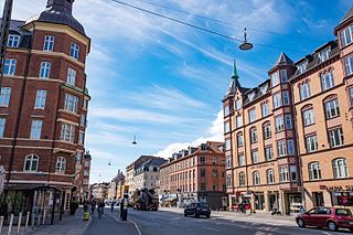
Districts of Copenhagen are often based on informal designations based on historic origins, often with alternative names and loosely defined boundaries. Copenhagen Municipality is divided into 10 official administrative districts but they often comprise areas of a heterogeneous character which are informally not seen as one district. Some districts have earlier been official subdivisions and thus have semi-official boundaries. Copenhagen postal code designations often correspond to district boundaries but in some cases differ from them, as an example parts of the city centre has the postal code København V which is generally associated with Vesterbro.

Amaliegade is a street in central Copenhagen, Denmark, which makes up the longer of the two axes on which the Rococo district Frederiksstaden is centred. Amaliegade extends from Sankt Annæ Plads to Esplanaden, passing through the central plaza of Amalienborg Palace on the way where it intersects Frederiksgade, the other, shorter but more prominent, axis of the district.
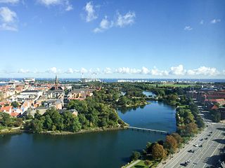
Stadsgraven is the canal which separates Christianshavn from the rest of Amager in Copenhagen, Denmark. It was originally a moat located in front of the Christianshavn Rampart as part of the city's Bastioned Ring Fortifications.

Churchillparken is a public park in Copenhagen, Denmark, occupying a tract of land between Kastellet, a 17th-century fortress, and the street Esplanaden. Located on the former esplanade which used to surround Kastellet, the area has a long history as a greenspace but received its current name in 1965 to commemorate Winston Churchill and the British assistance in the liberation of Denmark during World War II.

Borgergade is a street in central Copenhagen, Denmark. It runs from Gothersgade to Store Kongensgade. As one of relatively few streets in central Copenhagen, the street, in its western part, is dominated by modern buildings. The eastern part passes through the Nyboder district.

Dronningens Tværgade is a street in central Copenhagen, Denmark, which runs from Bredgade to Rosenborg Castle Garden. The street originally formed a link between the King's Garden and the Queen's Garden. With the Odd Fellows Mansion on Bredgade and the central pavilions of the east fringe of the castle garden located at each their end, the street has axial qualities. These are accentuated by the Dronningegården Estate, a Functionalist housing complex from the 1940s, which forms an urban space around the intersection with Adelgade.
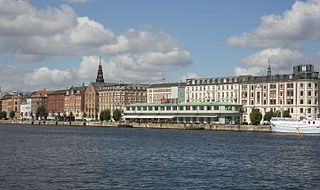
Havnegade is a waterfront promenade in central Copenhagen, Denmark, which runs between Knippelsbro and the mouth of the Nyhavn canal. Most of the street is lined with buildings from the 1860s and 1870s that were constructed as part of the redevelopment of the Gammelholm naval dockyards. It is the only place along Copenhagen's main harbourfront where residential buildings of that age face the water, although older warehouses and other industrial buildings elsewhere have been converted into residential use. The Modernist Bank of Denmark building is located at the western end of the street.

Holmens Kanal is a short street in central Copenhagen. Part of the main thoroughfare of the city centre, it extends from Kongens Nytorv for one block to a junction with a statue of Niels Juel where it turns right towards Holmens Bro while the through traffic continues straight along Niels Juels Gade. The street was originally a canal, hence the name, but was filled in the 1860s. Today it is dominated by bank and government buildings.

Torvegade is the central thoroughfare of Christianshavn in Copenhagen, Denmark, linking the city centre by way of Knippel Bridge with Amagerside Copenhagen at Christmas Møllers Plads. The street crosses Christianshavn Canal at Christianshavns Torv, the central square of the neighbourhood. The last section of the street runs on the embankment that across Stadsgraven.

Pilestræde is a street in central Copenhagen, Denmark. It is a side street to the pedestrianized shopping street Strøget and commonly associated with the newspaper publishing house Berlingske Media, which has its headquarters in the street.
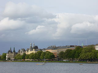
Vester, Nørre and Øster Søgade is a succession of streets along the eastern side of The Lakes in central Copenhagen, Denmark. The streets run from Gammel Kongevej to the south to the beginning of Østerbrogade at Lille Trianglen in the north. Vester Søgade runs from Gammel Kongevej to Gyldenløvesgade, Nørre Søgade runs from Gyldenløvesgade to Dronning Louises Bro, and Øster Søgade from Dronning Louises Bro to Lille Triangel.

Godthåbsvej is a street in the northwestern part of Copenhagen, Denmark. It begins at Bülowsvej in Frederiksberg as the direct continuation of Rosenørns Allé/Rolighedsvej and passes through Vanløse before reaching Bellahøj in Brønshøj. A metro station on the Copenhagen Metro City Circle Line is located at Aksel Møllers Have.

Christmas Møllers Plads is a major junction located in front of the embankment to Christianshavn on northern Amager in Copenhagen, Denmark. It links Torvegade, the main thoroughfare of Christianshavn, with Vermlandsgade, Amagerbrogade, Amagerfælledvej and Ved Stadsgraven-Amager Boulevard. Its name commemorates the Conservative politician Christmas Møller who had been active in the resistance movement during World War II and later served as Minister of Foreign Affairs.