
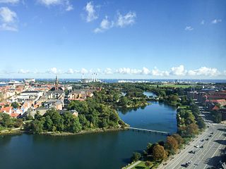
Amager in the Øresund is Denmark's most densely populated island, with more than 212,000 inhabitants on the small appendix to Zealand. The protected natural area of Naturpark Amager makes up more than one-third of the island's total area of 96 km2.

Ørestad is a developing city area in Copenhagen, Denmark, on the island of Amager.

Amagerbanen was a Danish railroad line from Copenhagen to Dragør on the island Amager, inaugurated on July 10, 1907.

Universiti is a light rapid transit (LRT) station in Kuala Lumpur served by the Kelana Jaya Line. This station serves the local population of University of Malaya and neighbouring Bangsar South, Pantai Dalam and Pantai Hill Park.

Islands Brygge is a harbourfront area in central Copenhagen, Denmark, located on the north-western coast of Amager. The neighbourhood is noted for its waterfront park Havneparken, which is one of the most popular areas along the Copenhagen harbourfront and the location of one of the Copenhagen Harbour Baths.

Copenhagen Municipality, also known in English as the Municipality of Copenhagen, located in the Capital Region of Denmark, is the largest of the four municipalities that constitute the City of Copenhagen, the other three being Dragør, Frederiksberg, and Tårnby. The Municipality of Copenhagen constitutes the historical city centre and the majority of its landmarks. It is the most populous in the country with a population of 646,812 inhabitants, and covers 86.4 square kilometres (33.4 sq mi) in area,. Copenhagen Municipality is located at the Zealand and Amager islands and totally surrounds Frederiksberg Municipality on all sides. The strait of Øresund lies to the east. The city of Copenhagen has grown far beyond the municipal boundaries from 1901, when Frederiksberg Municipality was made an enclave within Copenhagen Municipality. Frederiksberg has the largest population density of the municipalities of Denmark.
Amager Øst is one of the 10 official districts of Copenhagen, Denmark. It encompasses the part of Copenhagen located on the island of Amager, east of the major shopping street Amagerbrogade.Prior to an administrative reform in 2006-08, the district was known as Sundbyøster.
Districts of Copenhagen are often based on informal designations based on historic origins, often with alternative names and loosely defined boundaries. Copenhagen Municipality is divided into 10 official administrative districts but they often comprise areas of a heterogeneous character which are informally not seen as one district. Some districts have earlier been official subdivisions and thus have semi-official boundaries. Copenhagen postal code designations often correspond to district boundaries but in some cases differ from them, as an example parts of the city centre has the postal code København V which is generally associated with Vesterbro.

Amager Vest is one of the ten administrative districts of Copenhagen Denmark. It located on in the north-western part of the island of Amager, the largest island in the Øresund. The district is bordered by Amager Øst to the east along Amagerbrogade, the main shopping street and thoroughfare of the part of Copenhagen. Amager Vest is the largest of the ten new official administrative districts of Copenhagen, but has at the same time the smallest population. Only the most northern part can be considered as "urban area".
Stadsgraven is the canal which separates Christianshavn from the rest of Amager in Copenhagen, Denmark. It was originally a moat located in front of the Christianshavn Rampart as part of the city's Bastioned Ring Fortifications.
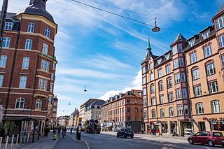
Amagerbrogade is the main shopping street and thoroughfare of the part of Copenhagen, Denmark that is located on the island of Amager. It begins at the end of the causeway which connects Amager to Christianshavn and the city centre on the other side of the harbour, and runs south until it reaches the municipal border with Tårnby where it continues as Amager Landevej. The street marks the border between Amager Vest and Amager Øst, two of the ten official districts of Copenhagen.
Christianshavns Torv is the central public square of the Christianshavn neighborhood in Copenhagen, Denmark. It is situated at the intersection of Torvegade and Christianshavn Canal, roughly at the center of the area.
Gammel Kongevej is the principal shopping street of Frederiksberg in Copenhagen, Denmark. Running roughly parallel to Frederiksberg Allé and Vesterbrogade, it extends from Vesterport station at the southern end of The Lakes and continues for some 1.8 km west to Frederiksberg City Hall Square where it continues as Smallegade. In the opposite end, Jernbanegade connects it to Copenhagen City Hall Square.

Eberts Villaby is an enclave of late 19th-century detached houses situated just off Amagerbrogade in the otherwise more dense Sundby district on Amager in Copenhagen, Denmark.

Sundby is a neighbourhood on Amager in Copenhagen, Denmark. It is often also referred to as Sundbyerne since a distinction is traditionally made between Sundbyvester and Sundbyøster, located on each their side of Amagerbrogade.

Holmbladsgade is one of the most lively streets in the Amagerbro district of Copenhagen, Denmark, connecting Amagerbrogade to Strandlodsvej on the east coast of Amager. The surrounding neighbourhood is variously referred to as Holmbladsgadekvarteret, Amagerbro or Sundby North.

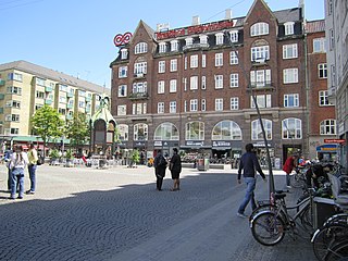
Amager Centret is a shopping centre on Amager, just off Amagerbrogade, in Copenhagen, Denmark. It is located next to Amagerbro Station.

Amager Boulevard is a street on Amager in Copenhagen, Denmark. It begins at Langebro Bridge and initially follows Stadsgraven east to a Y-junction from where it continues inland to Amagerbrogade while the street Ved Stadsgraven continues along the water to the Christmas Møllers Plads.

Christmas Møllers Plads is a major junction located in front of the embankment to Christianshavn on northern Amager in Copenhagen, Denmark. It links Torvegade, the main thoroughfare of Christianshavn, with Vermlandsgade, Amagerbrogade, Amagerfælledvej and Ved Stadsgraven-Amager Boulevard. Its name commemorates the Conservative politician Christmas Møller who had been active in the resistance movement during World War II and later served as Minister of Foreign Affairs.
Øresundsvej is a street in the East Amager district of Copenhagen, Denmark. It runs from Amagerbrogade in the west to Amager Strandvej in the east.
