
Nykøbing Falster is a southern Danish city, seat of the Guldborgsund kommune. It belongs to Region Sjælland. The city lies on Falster, connected by the 295-meter-long Frederick IX Bridge over the Guldborgsund waterway to the island of Lolland. The town has a population of 16,980. Including the satellite town Sundby on the Lolland side, with a population of 3,040 the total population is 20,020.

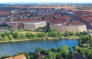
Ørestad is a developing city area in Copenhagen, Denmark, on the island of Amager.

Frederikssund is a Danish town, seat of the Frederikssund Municipality, in the Region Hovedstaden with a population of 16,614. It received the status of market town in 1810. The town is famous for its annual Viking Games as well as for the J.F. Willumsen museum. Since 1935, it has been connected to Hornsherred via the Kronprins Frederik Bridge.

Søllerød is a suburban district of Rudersdal Municipality in the northern outskirts of Copenhagen, Denmark. The original village, one of the oldest in the area, is perched on Søllerød Hill on the south side of Søllerød Lake. It merged with the neighbouring village of Øverød to the north and the modern district of Holte to the southwest in the middle of the 20th century and now forms part of the Greater Copenhagen area.

Sorgenfri Palace is a royal residence of the Danish monarch, located in Lyngby-Taarbæk Municipality, on the east side of Lyngby Kongevej, in the northern suburbs of Copenhagen. The surrounding neighbourhood is called Sorgenfri after it. Only the cellar and foundations survive of the first Sorgenfri House, which was built in 1705 to design by François Dieussart. The current house was built in 1756 by Lauritz de Thurah and later adapted and extended by Peter Meyn in the 1790s. Lauritz de Thurah has also designed buildings which flank the driveway closer to the road.

North Atlantic House is a cultural centre located on the harbour front in Copenhagen, Denmark, dedicated to preserve, promote and communicate culture and art from the North Atlantic area. It is made as a cooperation between Denmark, Iceland, Greenland and the Faroe Islands and includes three galleries and conference facilities. The centre also houses the Icelandic embassy and the permanent representations of Greenland and the Faroe Islands, as well as some commercial activities and enterprises related to the area.
Flintholm is a modern neighbourhood in the Frederiksberg district of Copenhagen, Denmark. Located just south of Flintholm station, on the border with Vanløse, it is the result of a redevelopment of a former gasworks site which began in 2004 and is still ongoing. The neighborhood covers an area of about 10 hectares and consists of a mixture of housing, offices, retail and several minor green spaces. The only surviving building from the gasworks, The Yellow Villa, now serves as a local cultural centre.

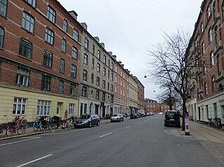
Holmbladsgade is one of the most lively streets in the Amagerbro district of Copenhagen, Denmark, connecting Amagerbrogade to Strandlodsvej on the east coast of Amager. The surrounding neighbourhood is variously referred to as Holmbladsgadekvarteret, Amagerbro or Sundby North.

Sølvgade is a street in central Copenhagen, Denmark, extending north-west from Borgergade to The Lakes where Fredens Bro connects it to Fredensgade. The section from Kronprinsessegade to Øster Voldgade follows the walled north-eastern margin of Rosenborg Castle Garden and the next section, from Øster Voldgade to the intersection with Farimagsgade, named Sølvtorvet although it is little more than a busy street junction, separates Copenhagen Botanical Garden from Østre Anlæg.

Kunstnerhjemmet on Gothersgade, opposite the Botanical Garden, in Copenhagen, Denmark, was built in the 1870s to provide affordable accommodation and studio facilities for artists. Founded at the initiative of Ferdinand Meldahl, the association behind its construction later also acquired a building on nearby Bartolinsgade. The apartments in the two buildings are open to young, emerging artists as well as aging ones and their widows.

Blegdamsvej is a street in Copenhagen, Denmark, connecting Sankt Hans Torv in Nørrebro to Trianglen in Østerbro. The busy artery Fredensgade separates the Nørrebro and Østerbro sections of the street from each other. The north side of the street is dominated by the Panum Building and Rigshospitalet, located on either side of Tagensvej.
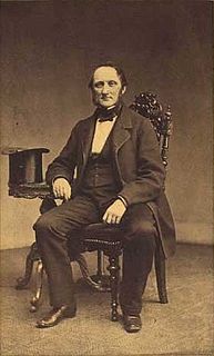
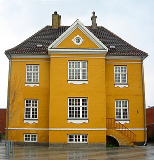
Lauritz Peter Holmblad, often referred to as L. P. Holmblad, was a Danish industrialist and philanthropist. His company, which was simply known as L. P. Holmblad, had activities in dyes, soap, glue and plating cards. Holmblad was also part of the circle around Carl Frederik Tietgen, co-founding several of his companies.

Brønshøj Rytterskole is a listed building on Brønshøj Torv in the Brønshøj-Husum district of Copenhagen, Denmark. It is owned by Copenhagen Municipality and used as a venue for local cultural events and meetings.

Jægersborg is a suburban neighbourhood in Gentofte Municipality, some 12 km north of central Copenhagen, Denmark.
Århusgade is a street in the Østerbro district of Copenhagen, Denmark. It extends east from Østerbrogade and passes under the railway just before entering the southernmost part of Nordhavn which is known as the Århusgade neighbourhood after it. The street has many cafés and small shops. The street is named after the City of Aarhus, the second largest city in Denmark.

Fuglevad is a locality on the Mølleåen river in Lyngby-Taarbæk Municipality in the northern suburbs of Copenhagen, Denmark. Fuglevad Watermill, located approximately one kilometer downstream from Lyndby Nordre Mølle, has a history that dates back to the 15th century but the current buildings are from the 1870s. Fuglevad Windmill, a smock mill from 1832, is now located inside the grounds of the Frilandsmuseet open-air museu which opened at the site in 1901. Fuglevad Station is located on the Nærum Line and is served by the railway company Lokaltog.

Lergravsparken is a public park situated on the north side of Øresundsvej in the East Amager district of Copenhagen, Denmark. It is bounded by Østrigsgade to the west, Lergravsvej to the north and Strandlodsvej to the east. Lergravsparken metro station is located in a corner of the park. Lergravparkens Skole, a public primary school, is located just west of the park.
Nørre Alle is a street in Copenhagen, Denmark, running from Blegdamsvej in Nørrebro in the south to Vibenshus Runddel in Østerbro in the north. It runs through University of Copenhagen's North Campus which is centred on its junction with Tagensvej. The section north of the junction, which separates Fælledparken to the east from the University Park to the west, is a busy artery. De Gamles By is situated on the west side of the more quiet, western portion.
Vermlandsgade is a major street on the northeastern part of Amager, Copenhagen, Denmark. It runs from Christmas Møllers Plads in the west to a roundabout on Prags Boulevard in the east and then continues south to Holmbladsgade.
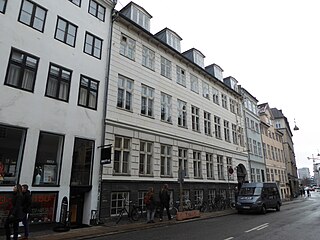
Huset KBH is a cultural centre located at Rådhusstræ 13 in central Copenhagen, Denmark. It occupies three old townhouses at Rådhusstræde 13 and Magstræde 12–14 as well as a former warehouse. The building at Rådhusstræde 13 was listed in the Danish registry of protected buildings and places in 1945.
