The Copenhagen Metro is a 24/7 rapid transit system in Copenhagen, Denmark, serving the municipalities of Copenhagen, Frederiksberg, and Tårnby.

The rail transport system in Denmark consists of 2,633 km of railway lines, of which the Copenhagen S-train network, the main line Helsingør-Copenhagen-Padborg, and the Lunderskov-Esbjerg line are electrified. Most traffic is passenger trains, although there is considerable transit goods traffic between Sweden and Germany.

M1 of the Copenhagen Metro, colored green on the map, runs from Vanløse to Vestamager. It connects the Ørestad neighborhood of Copenhagen, Denmark, to the city center. The line is elevated while traveling through Ørestad, while it runs in a tunnel below the city center. From Christianshavn to Vanløse, the line is shared with M2.
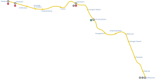
M2 is a line of the Copenhagen Metro, colored yellow on the map. It runs from Vanløse to Lufthavnen through the center of Copenhagen, sharing track with the M1 from Vanløse to Christianshavn. The line was built along with M1 as part of the redevelopment of Ørestad. The principle of the line was passed in 1992, and construction commenced in 1998. The line opened in several stages between 2002 and 2007. It is owned by Metroselskabet and operated by Metro Service, and operates with a headway between four and twenty minutes.

The City Circle Line or M3 is a loop line of the Copenhagen Metro. It has been claimed by COWI A/S that the City Circle Line is the largest construction project to have taken place in Copenhagen during the last 400 years. The network's total length is 15.5 kilometres (9.6 mi) and has 17 stations. The line opened on 29 September 2019.

Ørestad is a developing city area in Copenhagen, Denmark, on the island of Amager.

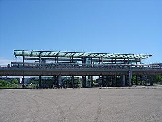
Ørestad is a junction station served by both the Copenhagen Metro and regional trains in Copenhagen, Denmark. The penultimate stop of the M1 Line, it is located in zone 3 in the west-central section of the island of Amager.

Vestamager is a rapid transit station of the Copenhagen Metro in Copenhagen, Denmark. The terminus of the M1 line, it is located in zone 3 in the southwestern section of the island of Amager.
DR Byen Station is a rapid transit station on the Copenhagen Metro. It is served by the M1 line. The station is elevated from ground level. It is located in fare zones 1 and 3, and opened in 2002.

Lindevang Station is a rapid transit station on the Copenhagen Metro in Frederiksberg, Denmark. It serves the M1 and M2 lines. It is located where the Metro line crosses Dalgas Boulevard in Frederiksberg. It opened 12 October 2003. It is located in fare zone 2.

Amager Strand Station is a rapid transit station on the Copenhagen Metro, located in the Sundbyøster district of Copenhagen. It opened on 28 September 2007. It is named after the nearby beach at Amager Strandpark.

Copenhagen Airport, Kastrup Station is a railway station in Tårnby, Denmark, served by DSB’s regional trains including the Øresundtrain network. The nearby Lufthavnen metro station is served by the Copenhagen Metro’s line M2. The station opened on 27 September 1998, and was subsequently reconstructed and reopened on 28 September 2007, with a connection to the Copenhagen Metro opening the following month. The stations take their names from Copenhagen Airport, to which they are connected. It is linked to Ørestad station on the M1 line by DSB regional trains. It is located in fare zone 4.

Islands Brygge is a harbourfront area in central Copenhagen, Denmark, located on the north-western coast of Amager. The neighbourhood is noted for its waterfront park Havneparken, which is one of the most popular areas along the Copenhagen harbourfront and the location of one of the Copenhagen Harbour Baths.
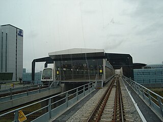
Lufthavnen Station is a rapid transit station of the Copenhagen Metro, located at Copenhagen Airport on the island of Amager. The station is the terminus of the M2 line and is located in fare zone 4.

The Finger Plan is an urban plan from 1947 which provides a strategy for the development of the Copenhagen metropolitan area, Denmark. According to the plan, Copenhagen is to develop along five 'fingers', centred on S-train commuter rail lines, which extend from the 'palm', that is the dense urban fabric of central Copenhagen. In between the fingers, green "wedges" are intended to provide land for agriculture and recreational purposes.

Teglholmen is a peninsula in the South Harbour of Copenhagen, Denmark, located between Sluseholmen and Enghave Brygge. The former dockland area used to house heavy industry. While some industry activities remain in the area, but since most industry left the area, starting in the 1970s, it has undergone massive redevelopment, though some industrial activities remain, most notably MAN B&W Diesel's motor development plant. Today the area houses both a considerable number of Danish and regional headquarters of multinational companies and residential developments. Teglholmen is home to Aalborg University's AAU Cph Campus as well as TV 2's activities in Copenhagen.

Amager Vest is one of the ten administrative districts of Copenhagen Denmark. It located on in the north-western part of the island of Amager, the largest island in the Øresund. The district is bordered by Amager Øst to the east along Amagerbrogade, the main shopping street and thoroughfare of the part of Copenhagen. Amager Vest is the largest of the ten new official administrative districts of Copenhagen, but has at the same time the smallest population. Only the most northern part can be considered as "urban area".

The South Campus is one of University of Copenhagen's four campuses in Copenhagen, Denmark. It is situated on Amager just south of Njalsgade, between Ørestad Boulevard and Amager Fælledvej, forming the northernmost part of Ørestad. It is home to the Faculty of Humanities which will later be joined by the Faculty of Theology and the Faculty of Law. Once completed, the campus will be home to about 12,000 students and researchers.

Enghave Brygge is a waterfront area in the Southern Docklands of Copenhagen, Denmark. It is located between Teglholmen to the south and Kalvebod Brygge to the north. Currently an abandoned industrial site, a plan for its redevelopment was adopted in July 2013. The most prominent landmark in the area is the H. C. Ørsted Power Station.
Transport in Copenhagen and the surrounding area relies on a well established infrastructure making it a hub in Northern Europe thanks to its road and rail networks as well as its international airport. Thanks to its many cycle tracks, Copenhagen is considered to be one of the world's most bicycle-friendly cities. The metro and S-train systems are key features of the city's well-developed public transport facilities. Since July 2000, the Øresund Bridge has served as a road and rail link to Malmö in Sweden. The city is also served by ferry connections to Oslo in Norway while its award-winning harbour is an ever more popular port of call for cruise ships.