
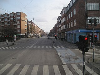
The Copenhagen Metro is a 24/7 rapid transit system in Copenhagen, Denmark, serving the municipalities of Copenhagen, Frederiksberg, and Tårnby.

M1 of the Copenhagen Metro, colored green on the map, runs from Vanløse to Vestamager. It connects the Ørestad neighborhood of Copenhagen, Denmark, to the city center. The line is elevated while traveling through Ørestad, while it runs in a tunnel below the city center. From Christianshavn to Vanløse, the line is shared with M2.
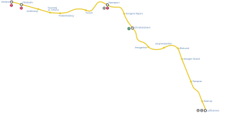
M2 is a line of the Copenhagen Metro, colored yellow on the map. It runs from Vanløse to Lufthavnen through the center of Copenhagen, sharing track with the M1 from Vanløse to Christianshavn. The line was built along with M1 as part of the redevelopment of Ørestad. The principle of the line was passed in 1992, and construction commenced in 1998. The line opened in several stages between 2002 and 2007. It is owned by Metroselskabet and operated by Metro Service, and operates with a headway between four and twenty minutes.
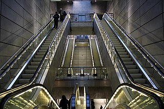
Nørreport Station is an S-train, metro and main line railway station in Copenhagen, Denmark. It is located in the district of Indre By, and is named after the historic Nørreport city gate, at the original location of which it is located. It is one of the busiest railway stations in Denmark, serving 165,000 people daily. The entire station is underground, with three pairs of platforms: one for S-trains, one for main line trains and one for the metro. The station is located on the Boulevard Line of the S-train and main line network. Several bus lines run through and start from Nørreport above ground.

The City Circle Line or M3 is a loop line of the Copenhagen Metro. It has been claimed by COWI A/S that the City Circle Line is the largest construction project to have taken place in Copenhagen during the last 400 years. The network's total length is 15.5 kilometres (9.6 mi) and has 17 stations. The line opened on 29 September 2019.
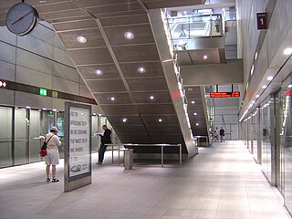
Forum Station is a rapid transit station on the Copenhagen Metro in Frederiksberg, Denmark. The station opened in 2003. It serves the M1 and M2 lines and connects with bus services. The station lies adjacent to Forum Copenhagen, a large special events venue, which has given the station its name. The station is in fare zone 1.

Vanløse Station is a S-train and Copenhagen Metro station in the Vanløse district of Copenhagen, Denmark. The metro station at street level is the western terminus of lines M1 and M2. S-trains on the Frederikssund radial stop at an upper level to the south of the Metro station. It is located in fare zone 2.

Frederiksberg Station is an underground Copenhagen Metro station located at Falkonér Plads, off Falkonér Allé, in the Frederiksberg district of Copenhagen, Denmark. The station is an interchange station between the M1/M2 and M3 lines and is in fare zone 2. Nearby landmarks include Frederiksberg Centret, Falkoner Center, Frederiksberg Gymnasium, Frederiksberg Central Library and Copenhagen Business School's Solbjerg Campus.

Flintholm Station is an S-train and Metro interchange junction station in Copenhagen, Denmark. It opened on 24 January 2004, and it is located in the west of Copenhagen where the Frederikssund S-train Line crosses the S-train Ring Line. It is located in fare zone 2.
Ringbanen is an S-train line in Copenhagen. Its route is roughly semicircular, running around the central part of Copenhagen and connecting the S-train radials about 5 km out.

Lergravsparken Station is a deep-level Copenhagen Metro station in the East Amager district of Copenhagen, Denmark. It is located on Øresundsvej in a corner of the public park Lergravsparken from which it takes its name. It opened in 2002.

Amagerbro Station is a rapid transit station on the Copenhagen Metro, located in the Sundbyøster district of Copenhagen. It opened in 2002.

Fasanvej Station is a rapid transit station on the Copenhagen Metro in Frederiksberg, Denmark. It was known as Solbjerg Station until 25 September 2006. The station opened 12 October 2003, and serves the M1 and M2 lines. It is located in fare zone 2.

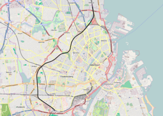
Frederiksberg is a part of the Capital Region of Denmark. It is formally an independent municipality, Frederiksberg Municipality, separate from Copenhagen Municipality, but both are a part of the City of Copenhagen. It occupies an area of less than 9 km2 and had a population of 103,192 in 2015.

H. C. Ørsteds Vej is a street in the Frederiksberg district of Copenhagen, Denmark. It runs from Gammel Kongevej in the south to Åboulevard on the border with Nørrebro in the north, linking Alhambravej in the south with Griffenfeldsgade in the north.

Godthåbsvej is a street in the northwestern part of Copenhagen, Denmark. It begins at Bülowsvej in Frederiksberg as the direct continuation of Rosenørns Allé/Rolighedsvej and passes through Vanløse before reaching Bellahøj in Brønshøj. A metro station on the Copenhagen Metro City Circle Line is located at Aksel Møllers Have.
Peter Bangs Vej is a 2.2 km long street in Frederiksberg, a city in the Copenhagen area on the island of Zealand, Denmark. The direct continuation of Smallegade, it initially runs west, from Nordre Fasanvej, but then turns south along the east side of Damhus Lake to meet Roskildevej. There is a large sports complex on the south end of the street with the football club F.C. Copenhagen's training facilities as well as the multi-purpose venue K.B. Hallen.

Finsensvej is a major street in the Frederiksberg district of Copenhagen, Denmark. The direct continuation of Howitzvej, it runs from Nordre Fasanvej in the east to the northern end of Sønderjyllands Allé in the west where it turns into Jernbane Allé on the municipal border with Vanløse. The street crosses Dalgas Boulevard and passes under the S-train network's Frederikssund radial. The modern Flintholm neighbourhood is located on the north side of the street and the Lindevang Park on its south side. The street is named after the Nobel Prize-winning physician Niels Ryberg Finsen.

Aksel Møllers Have is a public greenspace and early Modernist housing estate located at Godthåbsvej 35–41 in the Frederiksberg district of Copenhagen, Denmark. One of the stations on Copenhagen Metro's City Circle Line is located on the square.

Kingosgade is a street straddling the border between Vesterbro and Frederiksberg in Copenhagen, Denmark. It runs from Vesterbrogade in the south to Frederiksberg Allé in the north, linking Enghavevej with Alhambravej.

