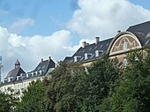
Østerbro is one of the 10 official districts of Copenhagen, Denmark. It is located just north of the city centre, outside the old city gate Østerport which, after it was moved around 1700, used to be located close to present-day Østerport Station. From the beginning, Østerbro has been a wealthy district, and it remains one of the most affluent areas in Copenhagen.

The City Circle Line or M3 is a loop line of the Copenhagen Metro. It has been claimed by COWI A/S that the City Circle Line is the largest construction project to have taken place in Copenhagen during the last 400 years. The network's total length is 15.5 kilometres (9.6 mi) and has 17 stations. The line opened on 29 September 2019.
Østerport station is a metro, S-train and main line railway station in Copenhagen, Denmark. It is located between the districts of Indre By and Østerbro, and is named for the historic Østerport city gate, near the original location of which it is located.

Nordhavn station is a commuter rail and rapid transit railway station in Copenhagen, Denmark.

The M4 of the Copenhagen Metro connects Nordhavn in the north with Sydhavn in the south. The central part of the line shares tracks with the City Circle Line (M3).
Districts of Copenhagen are often based on informal designations based on historic origins, often with alternative names and loosely defined boundaries. Copenhagen Municipality is divided into 10 official administrative districts but they often comprise areas of a heterogeneous character which are informally not seen as one district. Some districts have earlier been official subdivisions and thus have semi-official boundaries. Copenhagen postal code designations often correspond to district boundaries but in some cases differ from them, as an example parts of the city centre has the postal code København V which is generally associated with Vesterbro.

Oslo Plads is a public square in the Østerbro area of Copenhagen, Denmark. The square received its name in 1962. Before then, the square was part of the street Østerbrogade. In 1962, the part of Østerbrogade that stretched from Kristianiagade to Lille Triangel was renamed Dag Hammarskjölds Allé, while the inner part of Østerbrogade was named Oslo Plads. The name also extends to the neighborhood north of Østbanegade, where many of the streets are named after Norwegian cities.

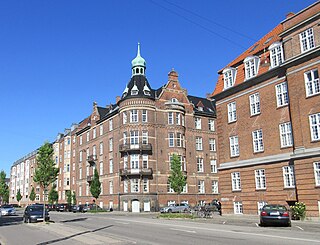
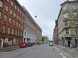
Østerbrogade is the principal shopping street and thoroughfare in the Østerbro district of Copenhagen, Denmark. It extends from Lille Triangel at the north-eastern tip of The Lakes, passes Trianglen, and continues to Svanemøllen station from where it becomes Strandvejen.

Amerika Plads is a public square and surrounding neighbourhood in the Østerbro district of Copenhagen, Denmark. It is the result of a redevelopment of an area in the southern part of the former Freeport of Copenhagen into a mixed-use neighbourhood which consists of dwellings, offices and retail establishments, combining converted historic buildings and modern architecture. The former Free Port Station building was put in storage during the redevelopment and is now located in the middle of the square where it serves as a café. The area is to the west bounded by Kalkbrænderihavnsgade, part of a major thoroughfare, and to the east by Dampfærgevej connected to Kalkbrænderihavnsgade in both ends and separating Amerika Plads from America Quay, the western quay of the Southern Free Port dock. The name of the area, like that of the quay, is a reference to the large passenger ships which used to transport Danish emigrants to New York City during the first half of the 20th century.

Trianglen is a central junction and public space in the Østerbro district of Copenhagen, Denmark. Five streets meet in the junction: Blegdamsvej, Øster Allé, Østerbrogade, Nordre Frihavnsgade and Odensegade. Trianglen is a station on the City Circle Line of the Copenhagen Metro.

Strandboulevarden is a major street in the Østerbro district of Copenhagen, Denmark. It runs from Fridtjof Nansens Plads as in the south to Østerbrogade in the north, linking Kristianiagade with Jagtvej.

Randersgade is a street in the Østerbro district of Copenhagen, Denmark, linking Nordre Frihavnsgade in the south to Strandboulevarden in the north. The small square Bopas Plads is located on the corner of Randersgade with Viborggade.

Nordre Frihavnsgade is a street in the Østerbro district of Copenhagen, Denmark, linking the junction Trianglen in the southwest with Østbanegade In the northeast. The street passes the two small squares Victor Borges Plads and Melchiors Plads. An underpass under the raised railway tracks at the end of the street provides access to Nordhavn's Århusgade neighbourhood.

Gunnar Nu Hansens Plads is a public space in the Østerbro district of Copenhagen, Denmark. It consists of a triangular plaza, located on the west side of Østerbrogade, just north of Parken Stadium, which turns into a wide street and continues for about 200 m to Fælledparken, The street then continues southwest as Per Henrik Lings Allé to Øster Allé. Several sports venues, some of which are listed, are located on the south side of the square. The former Østerfælled Barracks, now a mixed-use development known as Østerfælled Torv, are located on its north side.
Kristianiagade is a street located close to Østerport station in the Østerbro district of Copenhagen, Denmark. Buildings in the street include Domus Medica, a former noble town mansion which now houses the Danish Medical Association. The west side of the street is mostly lined with late 19th century villas of which several now serve as embassies. The street is named after the capital of Norway, Oslo, in recognition of the close ties between the two countries that were part of Denmark-Norway until 1814.

Glacisgården is a listed, Jugendstil-style building located at Østbanegade 11 in the Østerbro district of Copenhagen, Denmark.

Viborggade is a street in the Østerbro district of Copenhagen, Denmark, linking Østerbrogade in the west with Strandboulevarden in the east. The street is closed to through traffic at Bopa Plads, a small square located at the intersection with Randersgade.
Classensgade is a street in the Østerbro district of Copenhagen, Denmark. It runs from Østerbrogade in the southwest to Østbanegade in the northeast.
Gefion and Gylfe, situated at Østbanegade 19–21, between Stavangergade and Fridtjof Nansens Plads, is a pair of National Romantic high-end apartment buildings attached to each other by an archway across Mandalsgade in the Østerbro district of Copenhagen, Denmark. The symmetrical building complex was originally located in the axis of the Langelinie Bridge, an Asger Ostenfeld-designed steel bridge spanning the railway tracks just north of Østerport station, now replaced by a bicycle and footbridge. The two buildings were individually listed in the Danish registry of protected buildings and places in 2000. The Irish embassy is based in Gylfe. In Norse mythology, Gefion is the goddess who plouged Zealand out of Sweden. Gylfe is the king who challenged her to do so.