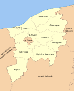
Boleniec is a former village in the administrative district of Gmina Smołdzino, within Słupsk County, Pomeranian Voivodeship, in northern Poland. It lies approximately 11 kilometres (7 mi) north-east of Smołdzino, 36 km (22 mi) north-east of Słupsk, and 94 km (58 mi) north-west of the regional capital Gdańsk.
Bukowa is a village in the administrative district of Gmina Smołdzino, within Słupsk County, Pomeranian Voivodeship, in northern Poland. It lies approximately 9 kilometres (6 mi) south-west of Smołdzino, 17 km (11 mi) north-east of Słupsk, and 100 km (62 mi) west of the regional capital Gdańsk.
Człuchy is a village in the administrative district of Gmina Smołdzino, within Słupsk County, Pomeranian Voivodeship, in northern Poland. It lies approximately 2 kilometres (1 mi) west of Smołdzino, 25 km (16 mi) north-east of Słupsk, and 99 km (62 mi) west of the regional capital Gdańsk.
Czysta is a village in the administrative district of Gmina Smołdzino, within Słupsk County, Pomeranian Voivodeship, in northern Poland. It lies approximately 7 kilometres (4 mi) south-west of Smołdzino, 35 km (22 mi) north-east of Słupsk, and 112 km (70 mi) west of the regional capital Gdańsk.
Gardna Mała is a village in the administrative district of Gmina Smołdzino, within Słupsk County, Pomeranian Voivodeship, in northern Poland. It lies approximately 5 kilometres (3 mi) south-west of Smołdzino, 21 km (13 mi) north-east of Słupsk, and 100 km (62 mi) west of the regional capital Gdańsk.
Gardna Wielka is a village in the administrative district of Gmina Smołdzino, within Słupsk County, Pomeranian Voivodeship, in northern Poland. It lies approximately 5 kilometres (3 mi) south-west of Smołdzino, 21 km (13 mi) north-east of Słupsk, and 100 km (62 mi) west of the regional capital Gdańsk.

Kluki is a village in the administrative district of Gmina Smołdzino, within Słupsk County, Pomeranian Voivodeship, in northern Poland. It lies approximately 9 kilometres (6 mi) east of Smołdzino, 32 km (20 mi) north-east of Słupsk, and 91 km (57 mi) north-west of the regional capital Gdańsk.
Komnino is a village in the administrative district of Gmina Smołdzino, within Słupsk County, Pomeranian Voivodeship, in northern Poland. It lies approximately 9 kilometres (6 mi) south-west of Smołdzino, 17 km (11 mi) north of Słupsk, and 102 km (63 mi) west of the regional capital Gdańsk.
Łokciowe is a village in the administrative district of Gmina Smołdzino, within Słupsk County, Pomeranian Voivodeship, in northern Poland. It lies approximately 5 kilometres (3 mi) north-east of Smołdzino, 30 km (19 mi) north-east of Słupsk, and 95 km (59 mi) west of the regional capital Gdańsk.
Przybynin is a village in the administrative district of Gmina Smołdzino, within Słupsk County, Pomeranian Voivodeship, in northern Poland. It lies approximately 6 kilometres (4 mi) north-east of Smołdzino, 31 km (19 mi) north-east of Słupsk, and 96 km (60 mi) north-west of the regional capital Gdańsk.
Retowo ; German: Rotten is a village in the administrative district of Gmina Smołdzino, within Słupsk County, Pomeranian Voivodeship, in northern Poland. It lies approximately 7 kilometres (4 mi) south-west of Smołdzino, 20 km (12 mi) north of Słupsk, and 102 km (63 mi) west of the regional capital Gdańsk.

Siecie is a village in the administrative district of Gmina Smołdzino, within Słupsk County, Pomeranian Voivodeship, in northern Poland. It lies approximately 5 kilometres (3 mi) south of Smołdzino, 22 km (14 mi) north-east of Słupsk, and 96 km (60 mi) west of the regional capital Gdańsk.
Siedliszcze is a settlement in the administrative district of Gmina Smołdzino, within Słupsk County, Pomeranian Voivodeship, in northern Poland. It lies approximately 6 kilometres (4 mi) south of Smołdzino, 20 km (12 mi) north-east of Słupsk, and 98 km (61 mi) west of the regional capital Gdańsk.

Smołdziński Las is a village in the administrative district of Gmina Smołdzino, within Słupsk County, Pomeranian Voivodeship, in northern Poland. It lies approximately 4 kilometres (2 mi) north-east of Smołdzino, 29 km (18 mi) north-east of Słupsk, and 97 km (60 mi) west of the regional capital Gdańsk.
Stare Kluki is a former village in the administrative district of Gmina Smołdzino, within Słupsk County, Pomeranian Voivodeship, in northern Poland. It lies approximately 9 kilometres (6 mi) east of Smołdzino, 31 km (19 mi) north-east of Słupsk, and 90 km (56 mi) west of the regional capital Gdańsk.
Stojcino is a village in the administrative district of Gmina Smołdzino, within Słupsk County, Pomeranian Voivodeship, in northern Poland. It lies approximately 5 kilometres (3 mi) south of Smołdzino, 21 km (13 mi) north-east of Słupsk, and 98 km (61 mi) west of the regional capital Gdańsk.
Wierzchocino is a village in the administrative district of Gmina Smołdzino, within Słupsk County, Pomeranian Voivodeship, in northern Poland. It lies approximately 5 kilometres (3 mi) south-east of Smołdzino, 24 km (15 mi) north-east of Słupsk, and 94 km (58 mi) west of the regional capital Gdańsk.
Witkowo is a village in the administrative district of Gmina Smołdzino, within Słupsk County, Pomeranian Voivodeship, in northern Poland. It lies approximately 6 kilometres (4 mi) south of Smołdzino, 22 km (14 mi) north-east of Słupsk, and 95 km (59 mi) west of the regional capital Gdańsk.
Wysoka is a village in the administrative district of Gmina Smołdzino, within Słupsk County, Pomeranian Voivodeship, in northern Poland. It lies approximately 6 kilometres (4 mi) south-west of Smołdzino, 20 km (12 mi) north-east of Słupsk, and 101 km (63 mi) west of the regional capital Gdańsk.
Żelazo is a village in the administrative district of Gmina Smołdzino, within Słupsk County, Pomeranian Voivodeship, in northern Poland. It lies approximately 4 kilometres (2 mi) south-east of Smołdzino, 26 km (16 mi) north-east of Słupsk, and 95 km (59 mi) west of the regional capital Gdańsk.