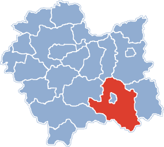
Nowy Sącz County is a unit of territorial administration and local government (powiat) in Lesser Poland Voivodeship, southern Poland, on the Slovak border. It came into being on January 1, 1999, as a result of the Polish local government reforms passed in 1998. Its administrative seat is the city of Nowy Sącz, although the city is not part of the county. The county contains five towns: Krynica-Zdrój, 31 km (19 mi) south-east of Nowy Sącz, Stary Sącz, 9 km (6 mi) south-west of Nowy Sącz, Grybów, 19 km (12 mi) east of Nowy Sącz, Piwniczna-Zdrój, 21 km (13 mi) south of Nowy Sącz, and Muszyna, 33 km (21 mi) south-east of Nowy Sącz.

Kunów is a village in the administrative district of Gmina Chełmiec, within Nowy Sącz County, Lesser Poland Voivodeship, in southern Poland. It lies approximately 8 kilometres (5 mi) south-east of Chełmiec, 6 km (4 mi) south-east of Nowy Sącz, and 79 km (49 mi) south-east of the regional capital Kraków.
Kurów is a village in the administrative district of Gmina Chełmiec, within Nowy Sącz County, Lesser Poland Voivodeship, in southern Poland. It lies approximately 7 kilometres (4 mi) north of Chełmiec, 8 km (5 mi) north-west of Nowy Sącz, and 67 km (42 mi) south-east of the regional capital Kraków.
Przydonica is a village in the administrative district of Gmina Gródek nad Dunajcem, within Nowy Sącz County, Lesser Poland Voivodeship, in southern Poland. The namesake of "our Lady of Prydonic" It lies 14 kilometres (9 mi) north-east of Nowy Sącz and 71 km (44 mi) south-east of the regional capital Kraków. Not to be confused with the nearby and more populous, Przydonica-Glinik
Królowa Polska is a village in the administrative district of Gmina Kamionka Wielka, within Nowy Sącz County, Lesser Poland Voivodeship, in southern Poland. It lies approximately 4 kilometres (2 mi) north-east of Kamionka Wielka, 10 km (6 mi) east of Nowy Sącz, and 82 km (51 mi) south-east of the regional capital Kraków.
Bilsko is a village in the administrative district of Gmina Łososina Dolna, within Nowy Sącz County, Lesser Poland Voivodeship, in southern Poland. It lies approximately 2 kilometres (1 mi) south of Łososina Dolna, 13 km (8 mi) north of Nowy Sącz, and 62 km (39 mi) south-east of the regional capital Kraków.
Rąbkowa is a village in the administrative district of Gmina Łososina Dolna, within Nowy Sącz County, Lesser Poland Voivodeship, in southern Poland. It lies approximately 3 kilometres (2 mi) south-east of Łososina Dolna, 13 km (8 mi) north of Nowy Sącz, and 63 km (39 mi) south-east of the regional capital Kraków.

Andrzejówka is a village in the administrative district of Gmina Muszyna, within Nowy Sącz County, Lesser Poland Voivodeship, in southern Poland, close to the border with Slovakia. It lies approximately 7 kilometres (4 mi) west of Muszyna, 32 km (20 mi) south of Nowy Sącz, and 102 km (63 mi) south-east of the regional capital Kraków.
Dubne is a village in the administrative district of Gmina Muszyna, within Nowy Sącz County, Lesser Poland Voivodeship, in southern Poland, close to the border with Slovakia. It lies approximately 8 kilometres (5 mi) south-east of Muszyna, 40 km (25 mi) south-east of Nowy Sącz, and 112 km (70 mi) south-east of the regional capital Kraków.

Leluchów is a village in the administrative district of Gmina Muszyna, within Nowy Sącz County, Lesser Poland Voivodeship, in southern Poland, close to the border with Slovakia. It lies approximately 7 kilometres (4 mi) south of Muszyna, 40 km (25 mi) south-east of Nowy Sącz, and 111 km (69 mi) south-east of the regional capital Kraków.
Milik is a village in the administrative district of Gmina Muszyna, within Nowy Sącz County, Lesser Poland Voivodeship, in southern Poland, close to the border with Slovakia. It lies approximately 5 kilometres (3 mi) north-west of Muszyna, 29 km (18 mi) south-east of Nowy Sącz, and 100 km (62 mi) south-east of the regional capital Kraków. It is located in the valley of the Milik river — a tributary of the Poprad.
Szczawnik is a village in the administrative district of Gmina Muszyna, within Nowy Sącz County, Lesser Poland Voivodeship, in southern Poland, close to the border with Slovakia. It lies approximately 4 kilometres (2 mi) north-west of Muszyna, 30 km (19 mi) south-east of Nowy Sącz, and 101 km (63 mi) south-east of the regional capital Kraków.

Wojkowa is a village in the administrative district of Gmina Muszyna, within Nowy Sącz County, Lesser Poland Voivodeship, in southern Poland, close to the border with Slovakia. It lies approximately 8 kilometres (5 mi) east of Muszyna, 38 km (24 mi) south-east of Nowy Sącz, and 110 km (68 mi) south-east of the regional capital Kraków.
Złockie is a village in the administrative district of Gmina Muszyna, within Nowy Sącz County, Lesser Poland Voivodeship, in southern Poland, close to the border with Slovakia. It lies approximately 3 kilometres (2 mi) north of Muszyna, 31 km (19 mi) south-east of Nowy Sącz, and 103 km (64 mi) south-east of the regional capital Kraków.
Gaboń-Praczka is a village in the administrative district of Gmina Stary Sącz, within Nowy Sącz County, Lesser Poland Voivodeship, in southern Poland. It lies approximately 8 kilometres (5 mi) south-west of Stary Sącz, 16 km (10 mi) south-west of Nowy Sącz, and 76 km (47 mi) south-east of the regional capital Kraków.

Gołkowice Dolne is a village in the administrative district of Gmina Stary Sącz, within Nowy Sącz County, Lesser Poland Voivodeship, in southern Poland. It lies approximately 5 kilometres (3 mi) south-west of Stary Sącz, 13 km (8 mi) south-west of Nowy Sącz, and 74 km (46 mi) south-east of the regional capital Kraków.
Moszczenica Wyżna is a village in the administrative district of Gmina Stary Sącz, within Nowy Sącz County, Lesser Poland Voivodeship, in southern Poland. It lies approximately 5 kilometres (3 mi) south-west of Stary Sącz, 13 km (8 mi) south-west of Nowy Sącz, and 77 km (48 mi) south-east of the regional capital Kraków.
Wola Krogulecka is a village in the administrative district of Gmina Stary Sącz, within Nowy Sącz County, Lesser Poland Voivodeship, in southern Poland. It lies approximately 6 kilometres (4 mi) south-east of Stary Sącz, 13 km (8 mi) south of Nowy Sącz, and 81 km (50 mi) south-east of the regional capital Kraków.


