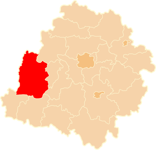
Minami-ku (南区) is one of the seven wards of Fukuoka City, Japan. As of 2004, it had a population of 247,913 people and an area of 30.98 km2. As of 2016, the population had increased to 255,000 people with 8,200 per km2. Its name literally means "south ward." It is bordered by the central, Hakata, Jonan, and Sawara wards of Fukuoka city, and also by the cities of Nakagawa and Kasuga. Sasabaru Station within the ward is on the JR Kagoshima main line. It also has three stations on the Tenjin Ōmuta Line.

Bartniki is a village in the administrative district of Gmina Milicz, within Milicz County, Lower Silesian Voivodeship, in south-western Poland. Prior to 1945 it was in Germany.

Corporation Island is an island in the River Thames in England. It is on the Tideway near Twickenham between Richmond Bridge and Richmond Railway Bridge and is opposite the river frontage at Richmond, London, England.
Karczówek is a village in the administrative district of Gmina Topólka, within Radziejów County, Kuyavian-Pomeranian Voivodeship, in north-central Poland. It lies approximately 7 kilometres (4 mi) south of Topólka, 25 km (16 mi) south-east of Radziejów, and 65 km (40 mi) south of Toruń.
Brzustowiec is a village in the administrative district of Gmina Drzewica, within Opoczno County, Łódź Voivodeship, in central Poland. It lies approximately 2 kilometres (1 mi) south-west of Drzewica, 14 km (9 mi) north-east of Opoczno, and 79 km (49 mi) south-east of the regional capital Łódź.
Stanisławice is a village in the administrative district of Gmina Gidle, within Radomsko County, Łódź Voivodeship, in central Poland. It lies approximately 5 kilometres (3 mi) north of Gidle, 9 km (6 mi) south of Radomsko, and 89 km (55 mi) south of the regional capital Łódź.
Biała Parcela is a village in the administrative district of Gmina Biała, within Wieluń County, Łódź Voivodeship, in central Poland. It lies approximately 11 kilometres (7 mi) north-west of Wieluń and 90 km (56 mi) south-west of the regional capital Łódź.
Dobużek-Kolonia is a village in the administrative district of Gmina Łaszczów, within Tomaszów Lubelski County, Lublin Voivodeship, in eastern Poland.
Kostki Duże is a village in the administrative district of Gmina Busko-Zdrój, within Busko County, Świętokrzyskie Voivodeship, in south-central Poland. It lies approximately 6 kilometres (4 mi) west of Busko-Zdrój and 48 km (30 mi) south of the regional capital Kielce.
Pasturka is a village in the administrative district of Gmina Pińczów, within Pińczów County, Świętokrzyskie Voivodeship, in south-central Poland. It lies approximately 5 kilometres (3 mi) south-east of Pińczów and 44 km (27 mi) south of the regional capital Kielce.
Wyglądały is a village in the administrative district of Gmina Jadów, within Wołomin County, Masovian Voivodeship, in east-central Poland.
Pluty is a village in the administrative district of Gmina Szydłowo, within Piła County, Greater Poland Voivodeship, in west-central Poland. It lies approximately 7 kilometres (4 mi) north-west of Szydłowo, 14 km (9 mi) north-west of Piła, and 94 km (58 mi) north of the regional capital Poznań.
Skrońsko is a village in the administrative district of Gmina Gorzów Śląski, within Olesno County, Opole Voivodeship, in south-western Poland.
Kowale is a village in the administrative district of Gmina Kolbudy, within Gdańsk County, Pomeranian Voivodeship, in northern Poland. It lies approximately 8 kilometres (5 mi) north-east of Kolbudy, 7 km (4 mi) north-west of Pruszcz Gdański, and 8 km (5 mi) south-west of the regional capital Gdańsk.
Grabowo is a village in the administrative district of Gmina Lubawa, within Iława County, Warmian-Masurian Voivodeship, in northern Poland. It lies approximately 18 km (11 mi) east of Iława and 52 km (32 mi) south-west of the regional capital Olsztyn.
Knowie is a settlement in the administrative district of Gmina Wierzchowo, within Drawsko County, West Pomeranian Voivodeship, in north-western Poland. It lies approximately 14 kilometres (9 mi) east of Wierzchowo, 35 km (22 mi) east of Drawsko Pomorskie, and 115 km (71 mi) east of the regional capital Szczecin.
Szczerbin is a settlement in the administrative district of Gmina Polanów, within Koszalin County, West Pomeranian Voivodeship, in north-western Poland.
Niedźwiady is a settlement in the administrative district of Gmina Szczecinek, within Szczecinek County, West Pomeranian Voivodeship, in north-western Poland.
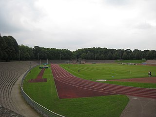
Stadion Gladbeck is a multi-use stadium in Gladbeck, Germany. It is used as the stadium of Germania Gladbeck matches. The capacity of the stadium is 15,000 spectators.

Blijdorp is a neighbourhood in northern Rotterdam and is part of the borough Noord. The neighbourhood has around 9500 inhabitants.