
Kingswood was, from 1974 to 1996, a non-metropolitan district of the County of Avon, England.

Black Brook is an 11.4-mile-long (18.3 km) stream located in southern New Hampshire in the United States. It is a tributary of the Merrimack River, which flows to the Gulf of Maine.

Zavala District is a district of Inhambane Province in south-east Mozambique. Its principal town is Zavala. The district is located at the east of the province, and borders with Inharrime District in the north and with Manjacaze District of Gaza Province in the west. In the east and in the south, the district is bounded by the Indian Ocean. The area of the district is 1,997 square kilometres (771 sq mi). It has a population of 139.616 as of 2007.
Kozłowo is a village in the administrative district of Gmina Strzegowo, within Mława County, Masovian Voivodeship, in east-central Poland.
Bogdany Wielkie is a village in the administrative district of Gmina Chorzele, within Przasnysz County, Masovian Voivodeship, in east-central Poland.
Czarzaste Małe is a village in the administrative district of Gmina Chorzele, within Przasnysz County, Masovian Voivodeship, in east-central Poland.
Lenino is a village (selo) in Lipetsky District of Lipetsk Oblast, Russia, located on the right bank of the Voronezh River.

Shimoyamamura Station is a railway station on the Iida Line in Iida, Nagano Prefecture, Japan, operated by Central Japan Railway Company.
Gümüşler Dam is a dam in Turkey. The development was backed by the Turkish State Hydraulic Works.

Hardman Street is a major street in Liverpool, England. If forms part of the A5039 and joins Leece Street to the west and Myrtle Street to the west. It lies within the postal district L1 in Liverpool city centre. It is named after the Hardman family of Allerton Hall.

The Cut Arts Centre is a theatre in the Suffolk town of Halesworth. It is a centre for arts in the community and offers music, theatre, dance, comedy, cinema, workshops and art exhibitions to the local area. It has a cafeteria and licensed bar and is a registered charity, relying on the support of the local community and its "500 Club" benefactors. Within The Cut, it facilitates business with rented office space.
Udangudi block is a revenue block in the Thoothukudi district of Tamil Nadu, India. It has a total of 16 panchayat villages.
Thanh Bình is a ward (phường) of Điện Biên Phủ in Điện Biên Province in northwestern Vietnam.

Lyset is an area of building society houses located on the north side of Vigerslev Allé in the Valby district of Copenhagen, Denmark. The development consists of 106 houses situated along Carl Langes vej, Steenbergsvej, Fengersvej, Eschrichtsvej and Steinsvej, just west of Valby station and south of the railway line towards Roskilde.

Puzhakkal River is a westward flowing river in Thrissur District of Kerala State in India. It originates from Killannoor Hills and empties into Thrissur Kole Wetlands. The total length of the river is 29 kilometres and a total of 234 km2 drainage area. The main tributaries are Parathodu, Naduthodu, Poomalathadu and Kattachirathodu.
Qurayha is a neighborhood in the sub-governorate of Bariq in the province of Asir, Saudi Arabia. It is located at an elevation of 402 metres (1,319 ft) and had a population of 4,556 in 2004. Qurayha was most important market of the neighbourhood. It is the capital of Musa ibn Ali tribe.
Jackson Township is a township in Lucas County, Iowa, USA.

The statue of the Earl Kitchener is an outdoor bronze statue by John Tweed depicting Herbert Kitchener, 1st Earl Kitchener, installed in 1926 and located on the south side of Horse Guards Parade in London, United Kingdom. The sculpture stands on a Portland stone plinth. It contains the following inscription: KITCHENER/ 1850–1916/ ERECTED BY PARLIAMENT.
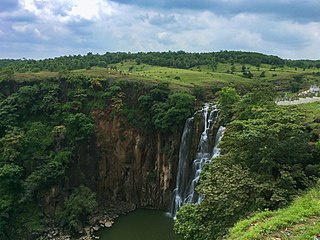
The Patalpani Waterfall is located in Mhow Tehsil of Indore district in the state of Madhya Pradesh, India. The waterfall is approximately 300 feet high. The area around Patalpani is a popular picnic and trekking spot.

Arap Islet is an uninhabited island of Turkey. According to Turkish Atlas it is situated on the borderline of Aegean Sea and the Mediterranean Sea. Administratively it is a part of Marmaris ilçe (district) of Muğla Province at 36°39′5″N28°8′48″E. It is very close to the mainland (Anatolia). The channel between the mainland and the island is quite shallow; no more than 6 metres (20 ft). Its surface area is about 0.025 square kilometres (0.0097 sq mi).


