The Kansas Turnpike is a 236-mile (380 km) controlled-access toll road that lies entirely within the US state of Kansas. It runs in a general southwest–northeast direction from the Oklahoma border to Kansas City. It passes through several major Kansas cities, including Wichita, Topeka, and Lawrence. The turnpike is owned and maintained by the Kansas Turnpike Authority (KTA), which is headquartered in Wichita.

U.S. Highway 159 (US 159) is a 83.6-mile-long (134.5 km) auxiliary route of US 59. It travels from Nortonville, Kansas at US 59 to New Point, Missouri, also at US 59. The highway permits through traffic on US 59 to bypass the cities of Atchison, Kansas and Saint Joseph, Missouri, traveling instead through Falls City, Nebraska and Hiawatha, Kansas.

Franklin D. Roosevelt East River Drive, commonly known as the FDR Drive, is a controlled-access parkway on the east side of the New York City borough of Manhattan. It starts near South and Broad Streets, just north of the Battery Park Underpass, and runs north along the East River to the 125th Street / Robert F. Kennedy Bridge interchange, where it becomes Harlem River Drive. All of FDR Drive is designated New York State Route 907L (NY 907L), an unsigned reference route.

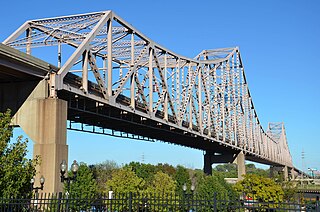
The Martin Luther King Bridge in St. Louis, Missouri, is a cantilever truss bridge of about 4,000 feet (1,200 m) in total length across the Mississippi River, connecting St. Louis with East St. Louis, Illinois. Opened in 1951, the bridge serves as traffic relief connecting the concurrent freeways of Interstate 55, Interstate 64, and U.S. Route 40 with the downtown streets of St. Louis. It was renamed for King in 1968 after the national civil rights leader was assassinated that year.

The flag of Des Moines, Iowa was designed by Walter T. Proctor. Set on a blue background is a red vertical stripe along the hoist with the right side of the stripe angling inward toward the hoist and a white balance of three horizontal "bridges".

James Barney Marsh was an American engineer and bridge designer. He patented a new design for arch bridges. Marsh gave Archie Alexander, the first African-American to graduate as an engineer from Iowa State University, his first job. Marsh worked in the bridge building business for over 50 years, and several of his bridges are listed in the National Register of Historic Places.

Franklin Square station is an unused, underground rapid transit station on the PATCO Speedline, operated by the Delaware River Port Authority. It is located under Franklin Square in Philadelphia, Pennsylvania, United States. Opened on June 7, 1936, the station was the first westbound and final eastbound station in Philadelphia, located just west of the Benjamin Franklin Bridge which carries trains over the Delaware River. The station has been opened for four separate intervals, each time eventually being closed for low ridership. As of 2024, the station is being refurbished and is expected to reopen by early 2025.

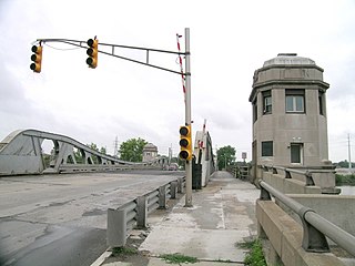
The Third Avenue Bridge is a swing bridge that carries southbound road traffic on Third Avenue over the Harlem River, connecting the boroughs of Manhattan and the Bronx in New York City. It once carried southbound New York State Route 1A. On the Manhattan side, the bridge funnels traffic into three locations: East 128th Street; the intersection of East 129th Street and Lexington Avenue; or FDR Drive in Manhattan.

Interstate 95 (I-95) is a major north–south Interstate Highway that runs along the East Coast of the United States from Miami, Florida, north to the Canada–United States border at Houlton, Maine. In the state of Pennsylvania, it runs 51.00 miles (82.08 km) from the Delaware state line near Marcus Hook in Delaware County in the southeastern part of the state northeast to the Delaware River–Turnpike Toll Bridge at the New Jersey state line near Bristol in Bucks County, closely paralleling the New Jersey state line for its entire length through Pennsylvania.

The Monroe Street Bridge is a deck arch bridge in the northwestern United States that spans the Spokane River in Spokane, Washington. It was built 114 years ago in 1911 by the city of Spokane, and was designed by city engineer John Chester Ralston, assisted in construction supervision by Morton Macartney with ornamentation provided by the firm of Kirtland Kelsey Cutter and Karl G. Malmgren as part of Cutter & Malmgren.

The Wells Street Bridge is a bascule bridge over the Chicago River, in downtown Chicago, Illinois, United States, which was built in 1922. Standing east of the Franklin Street Bridge and southeast of the Merchandise Mart, the bridge connects the Near North Side with "The Loop". The bridge is double-decked, the lower deck carrying three lanes of traffic south over the river with sidewalks on both sides of the street. The upper deck serves as a bridge for the Chicago Transit Authority's Brown and Purple lines. Bridge tenders' houses for controlling the bridge are on the northwest and southeast corners of the bridge.

Interstate 64 (I-64) passes through the Greater St. Louis area in the US state of Missouri. The entire route is concurrent with U.S. Route 40 (US 40). Because the road was a main thoroughfare in the St. Louis area before the development of the Interstate Highway System, it is not uncommon for locals to refer to the stretch of highway as "Highway 40" rather than "I-64". On December 6, 2009, the portion of the highway running through the city of St. Louis was named the Jack Buck Memorial Highway in honor of the late sportscaster.

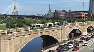
The Lechmere Viaduct is a concrete arch bridge connecting the West End neighborhood of Boston to East Cambridge, Massachusetts. Opened in 1912, the viaduct carries the MBTA's Green Line over the Charles River. It is adjacent to the Charles River Dam Bridge, but structurally separate.

The U.S. 40 and 59 Bridges are twin multi-beam girder bridges over the Kansas River at Lawrence, Kansas. The west bridge carries two lanes of southbound traffic, connecting to Vermont Street, while the east bridge carries two lanes of northbound traffic from Massachusetts Street. Both bridges converge on the north end to become North 2nd Street. The east bridge is also the third bridge to be built at this location.
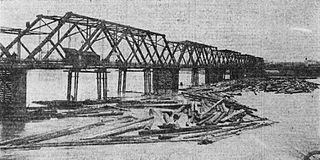
The Argentine Bridge was a one lane, thru-truss bridge over the Kansas River in Kansas City, Kansas. It was built in 1908, and removed in 1959, after the 18th Street Expressway Bridge was built to the east of it. It was damaged in the flood of 1951, after being crushed by a large oil tanker that floated from a field near the Kansas Avenue Bridge (West). After the flood, it never reopened, but was left in place until the replacement bridge was built. Today, a fallen pier is all that remains of the bridge, when the water in the river is low, it can be seen from the 18th Street Expressway Bridge when going southbound.
Armourdale community is a district in the lower part of the Kansas River valley in Kansas City, Kansas. It is a main district between the West Bottoms and the Rosedale, Kansas area. The Kansas River makes an oxbow curve around the entire district, which is home to Shawnee Park and Bill Clem Park.

The West Jefferson Avenue–Rouge River Bridge is a historic double-leaf bascule bridge in Wayne County, Michigan, at the border of the cities of Detroit and River Rouge. The bridge carries Jefferson Avenue, a major thoroughfare in Southwest Detroit, over the River Rouge, an important inland route for lake freighters. The bridge was built in 1922, and was listed on the National Register of Historic Places in 2000.
The Willard Bridge is an automobile crossing of the Kansas River at Willard, Kansas. The bridge was constructed by Frisbie Bridge Company of Topeka, Kansas, and opened in 1955 and rehabilitated in 1983. The bridge was demolished in October 2017 and rebuilt in August 2017.

The Madison Street Bridge, or Madison Bridge, refers to two different bridges that spanned the Willamette River in Portland, Oregon, from 1891 to 1900 and from 1900 to 1909. The bridges connected Madison Street, on the river's west bank, and Hawthorne Avenue, on the east bank, on approximately the same alignment as the existing Hawthorne Bridge. The original and later bridges are sometimes referred to as Madison Street Bridge No. 1 and Madison Street Bridge No. 2, respectively. The second bridge, built in 1900, has alternatively been referred to as the "rebuilt" Madison Street Bridge, rather than as a new bridge, because it was rebuilt on the same piers. Both were swing bridges, whereas their successor, the Hawthorne Bridge, is a vertical-lift-type.


