Related Research Articles

The National Mall is a landscaped park near the downtown area of Washington, D.C., the capital city of the United States. It contains and borders a number of museums of the Smithsonian Institution, art galleries, cultural institutions, and various memorials, sculptures, and statues. It is administered by the National Park Service (NPS) of the United States Department of the Interior as part of the National Mall and Memorial Parks unit of the National Park System. The park receives approximately 24 million visitors each year.

Dupont Circle is a historic roundabout park and neighborhood of Washington, D.C., located in Northwest D.C. The Dupont Circle neighborhood is bounded approximately by 16th Street NW to the east, 22nd Street NW to the west, M Street NW to the south, and Florida Avenue NW to the north. Much of the neighborhood is listed on the National Register of Historic Places. However, the local government Advisory Neighborhood Commission and the Dupont Circle Historic District have slightly different boundaries.

Logan Circle is a historic roundabout park and neighborhood of Washington, D.C., located in Northwest D.C. The majority of Logan Circle is primarily residential, except for the highly-commercialized 14th Street corridor that passes through the western part of the neighborhood. In the 21st century, Logan Circle has been the focus of urban redevelopment and become one of Washington's most expensive neighborhoods. Today, Logan Circle is also one of D.C.'s most prominent gay neighborhoods.

Meridian Hill Park, also informally known as Malcolm X Park, is a structured urban park located in the Washington, D.C. neighborhood of Columbia Heights; it also abuts the nearby neighborhood of Adams Morgan. The park was designed and built between 1912 and 1940. This 12-acre (49,000 m2), formally landscaped site is officially part of the National Capital Parks Unit of the National Park System, and is administered by the superintendent of nearby Rock Creek Park. Meridian Hill Park is bordered by 15th, 16th, W, and Euclid streets NW, and sits on a prominent hill 1.5 miles (2.4 km) directly north of the White House. Since 1969, the name "Malcolm X Park" has been used by many in honor of minister and activist Malcolm X.

Constitution Avenue is a major east–west street in the northwest and northeast quadrants of the city of Washington, D.C., in the United States. It was originally known as B Street, and its western section was greatly lengthened and widened between 1925 and 1933. It received its current name on February 26, 1931, though it was almost named Jefferson Avenue in honor of Thomas Jefferson.

The District of Columbia War Memorial commemorates the citizens of the District of Columbia who served in World War I. Located on the National Mall, it was constructed in 1931 as a domed, peristyle Doric temple.

16th Street Northwest is a prominent north–south thoroughfare in the northwest quadrant of Washington, D.C. Part of Pierre L'Enfant's design for the city, 16th Street begins just north of the White House across Lafayette Park at H Street and continues due north in a straight line passing K Street, Scott Circle, Meridian Hill Park, Rock Creek Park, and the Walter Reed Army Medical Center before crossing Eastern Avenue into Silver Spring, Maryland, where it ends at Georgia Avenue. From K Street to the District line, 16th Street is part of the National Highway System. The Maryland portion of the street is designated Maryland State Highway 390. The entire street is 6.4 miles (10.3 km) long.

Streetcars in Washington, D.C. transported people across the city and region from 1862 until 1962.

Ohio Drive is a street in Southwest Washington, D.C., located in East and West Potomac Parks and bordering the Tidal Basin, Washington Channel, and the Potomac River. It is a central organizing feature of East Potomac Park, providing the only major vehicular route to and through the area. Unlike most roadways named after states in the District of Columbia, Ohio Drive is not an avenue, nor it is heavily used like Wisconsin or Rhode Island Avenues. However, the segment from Independence Avenue to the Rock Creek and Potomac Parkway is an important commuter route.

Barney Circle is a small residential neighborhood located between the west bank of the Anacostia River and the eastern edge of Capitol Hill in southeast Washington, D.C., in the United States. The neighborhood is characterized by its sense of community, activism, walkability, and historic feel. The neighborhood's name derives from the eponymous former traffic circle Pennsylvania Avenue SE just before it crosses the John Philip Sousa Bridge over the Anacostia. The traffic circle is named for Commodore Joshua Barney, Commander of the Chesapeake Bay Flotilla in the War of 1812.
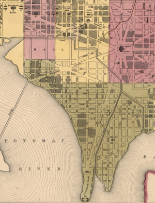
The Washington City Canal operated from 1815 until the mid-1850s in Washington, D.C. The canal connected the Anacostia River, termed the "Eastern Branch" at that time, to Tiber Creek, the Potomac River, and later the Chesapeake and Ohio (C&O) Canal. The canal became disused during the late 19th century and the city government covered over or filled in various sections in 1871.

Grant Circle is a traffic circle in the Petworth neighborhood of Northwest Washington, D.C. New Hampshire and Illinois Avenues NW, Varnum Street NW, and 5th Street NW all intersect at this circle. The park within the circle and the adjoining triangles is owned and administered by the National Park Service through its Rock Creek Park unit. The circle and the buildings flanking it were listed on the National Register of Historic Places in 2015.
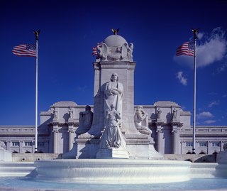
Columbus Fountain also known as the Columbus Memorial is a public artwork by American sculptor Lorado Taft, located at Union Station in Washington, D.C., United States. A centerpiece of Columbus Circle, Columbus Fountain serves as a tribute to the explorer Christopher Columbus. The unveiling in 1912 was celebrated all over Washington, DC over the course of three days with parades, concerts and fireworks gathering tens of thousands of people from all over the world.

The Memorial Continental Hall in Washington, D.C. is the national headquarters of the Daughters of the American Revolution (DAR). It is located at 1776 D Street NW, sharing a city block with the DAR's later-built Administration Building, and Constitution Hall. Completed in 1910, it is the oldest of the three buildings. It was the site of the 1922 Washington Naval Conference, a major diplomatic event in the aftermath of World War I. The building was declared a National Historic Landmark in 1972.

The Stephenson Grand Army of the Republic Memorial, also known as Dr. Benjamin F. Stephenson, is a public artwork in Washington, D.C. honoring Dr. Benjamin F. Stephenson, founder of the Grand Army of the Republic, a fraternal organization for Union veterans. The memorial is sited at Indiana Plaza, located at the intersection of 7th Street, Indiana Avenue, and Pennsylvania Avenue NW in the Penn Quarter neighborhood. The bronze figures were sculpted by J. Massey Rhind, a prominent 20th-century artist. Attendees at the 1909 dedication ceremony included President William Howard Taft, Senator William Warner, and hundreds of Union veterans.

The Peter Muhlenberg Memorial is a public monument in Washington, D.C. It honors John Peter Gabriel Muhlenberg, a Lutheran minister, Continental Army general, Federalist Era American politician, and member of the prominent Muhlenberg family. The memorial is located in a one-acre park bounded by Connecticut Avenue, Ellicott Street, and 36th Street NW on the eastern edge of Washington's Wakefield neighborhood. Designed by architect John Harbeson, it features at its center a bronze bust of Muhlenberg, sculpted by his descendant, Caroline M. Hufford. Completed in 1980, 52 years after its construction was authorized by Congress, attendees at the dedication ceremony included West German ambassador Peter Hermes.
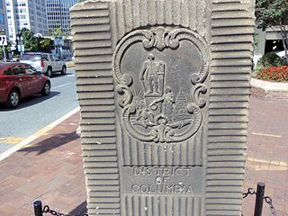
The Garden Club of America Entrance Markers in Washington, D.C. is a Multiple Property Submission, or MPS, on the National Register of Historic Places. The seven structures that make up the MPS are ceremonial markers at important entrance points to the District of Columbia from the state of Maryland. Sets of two markers are located in Westmoreland Circle, Friendship Heights and Chevy Chase Circle. A single marker is located along Georgia Avenue.

Western Avenue is one of three boundary streets between Washington, D.C., and the state of Maryland. It follows a southwest-to-northeast line, beginning at Westmoreland Circle in the south and ending at Oregon Avenue NW in the north. It is roughly 3.5 miles (5.6 km) in length. First proposed in 1893, it was constructed somewhat fitfully from about 1900 to 1931.

The U.S. government constructed a number of temporary buildings on the National Mall during World War I and II which stood from 1918 until 1971. They were built due to the urgent need for office space during wartime, but they remained in use during peacetime even though they disrupted the intended layout of the Mall according to the McMillan Plan for over half a century.
References
- 1 2 3 4 Alan Greenblatt (2000-07-07). "The Lost Brigade". Washington City Paper . Retrieved 2019-08-02.
- 1 2 3 John Kelly (2010-05-31). "Living memories of long ago war's dead". The Washington Post . Retrieved 2019-08-02.
- ↑ "To Dedicate Memorial Trees Next Sunday". The Evening Star. 1920-05-24. p. 20.
- 1 2 "Forgotten Men: Why Not Stop, Reflect, Repair?". The Washington Post . 1982-05-14. p. Metro; Bob Levey's Washington; B14.
- ↑ "Answers to Questions". The Salt Lake Tribune. 1924-02-05. p. 4.
- ↑ Latimer, Louise Payson (1924). Your Washington and Mine. Charles Scribner's Sons. p. 244.
- ↑ "Imposing Memorial Day Exercises to Cover Three-Day Period". The Evening Star. 1922-05-28. p. 4.
- ↑ "The District of Columbia War Dead, 1917-1918" (PDF). Association of the Oldest Inhabitants of the District of Columbia . 2016-09-06. Retrieved 2019-08-02.
- ↑ "AOI Members & Community Jointly Commemorate DC's World War I 16th Street Tree Memorial". Association of the Oldest Inhabitants of the District of Columbia . Retrieved 2019-08-02.