1886 St. Croix River log jam

Last updated

The 1886 log jam on the St Croix River near Taylors Falls, Minnesota Log jam on the St. Croix River 4343.jpg
The 1886 log jam on the St Croix River near Taylors Falls, Minnesota

On June 13, 1886, a log jam developed in the St. Croix River, close to Taylors Falls, Minnesota, and St. Croix Falls, Wisconsin. The river was used to transport large quantities of logs from the forests upstream to the sawmills, and log jams disrupted this business. The 1886 jam was described at the time by a local journalist as "the jammedest jam" he had encountered, [1] and was very difficult to clear, with hundreds of men working for six weeks to clear it, eventually using steamboats and dynamite. The jam was also a major tourist attraction, with thousands of spectators every day. After the jam was broken up in July, cleanup work to remove the logs on the river banks continued until September.

Contents

Background

After the Wisconsin Territory was established in 1836, large amounts of Native American land were ceded to the United States via the 1837 Treaty of St. Peters. Much of the land was covered in vast pine forests, and logging activities started soon after. [2] This was a winter activity, as the trees were so large that the only way to move them through the forests was by horse-drawn sleds, usually over ice. [3] Teams of lumberjacks cut down trees all winter and collected them by the shores of the St. Croix River and its tributaries. Pine is light and floats well, so the logs could be easily transported downstream by log driving in the river. The logs were marked with the relevant company's timber mark and then released into the river when the snow melted and the water rose in spring. [3] Workers known as "river pigs" guided the logs down the river and kept them moving, especially at difficult places like shallows, rapids or sharp bends. [2] Downstream, the logs were caught in the log boom at the St. Croix Boom Site, where they were sorted by owner, bundled into rafts and then sent to the sawmills. [4]

Causes and start of the 1886 log jam

Dalles of the St. Croix with the bend at Angle Rock Dalles Of St Croix.jpg
Dalles of the St. Croix with the bend at Angle Rock

In the area now covered by Interstate State Park, the St. Croix river marks the border between Minnesota and Wisconsin. It runs through a narrow gorge, the Dalles of the St. Croix, and makes a 90 degree turn at Angle Rock. The spring of 1886 was very dry, so the water level was too low to transport logs. This began to change when the Clam River dam was dynamited by the hermit Robert Davidson, who claimed the dam interfered with his meadow lands. [5] [6] Davidson was later charged for blowing up the dam and jailed for contempt of court. [7] The release of the Clam River water caused the St. Croix to rise slightly. Sluice dams on several other tributaries, including Kettle River and Snake River, [5] were opened as well, and coincidentally, heavy rain storms caused the rivers to rise further. [8] [9] [10] Large numbers of logs were dumped into the river all at once, [11] more than the river or the driving crews working along could control. Shortly after midnight on June 13, 1886, while the driving crews were asleep in their tents, the logs were caught at Angle Rock and quickly started to accumulate. [12] More and more logs ran onto the jam, including the 15 million board feet of the Clam River drive. [13] The Stillwater Messenger reprinted a report from the Taylor's Falls Journal about the start of the jam:

Last week the lumbermen wore a dejected and lost-their-last-friend look, for the water in the rivers was steadily falling and their logs were almost inextricably jammed at Wood river, Kettle river rapids, the mouth of the Namagon and other places. Crews had been discharged, and there seemed little prospect of getting the logs to market for an indefinite time. But it remained for Davidson, the hermit, to strike the key-note for a change to all this, by blowing out the Clam river dam with dynamite. The water from that stream caused a slight rise, and by one of Elias McKean's "most remarkable coincidences", there seemed to be a concert of action by the elements and otherwise. Other dams were opened, heavy rain storms flooded the upper country, and there was immediately a boom in the water of the Saint Croix, and logs went booming along toward the great Stillwater boom. Logs from the "low-water" drives were easily floated off, and came down stream in immense rafts, almost blockading the river as they moved along. Reaching the famous dells of the Saint Croix, their course was interrupted. The channel was too narrow and the current too sluggish to allow their passage in such large bodies, and shortly after midnight, Sunday morning, they "hung-up" and began jamming and piling. Something such a catastrophe has been anticipated, and yet it came unexpectedly, for the men who had been here for weeks, building sheerbooms at the eddies in the dells, and keeping watch to prevent a jam, were asleep in their tents, and their booms were broken, and the formation of the biggest jam ever known commenced before they were aware of it.

Stillwater Messenger [14]

An estimated 125 to 150 million board feet of pine became stuck in the log jam. [10] [15] For comparison, the average annual production of pine in the St. Croix valley between 1870 and 1889 was 241 million board feet. [16]

Clearing the log jam

1886 log jam, Dalles of the St Croix, with bridge in background Log jam at the Dalles of the St. Croix (Sargent).jpg
1886 log jam, Dalles of the St Croix, with bridge in background

Smaller log jams could be cleared just by human labor, with river pigs releasing key logs, [4] but this log jam was more difficult and dammed up the river. [10] On June 18, 1886, the New York Times reported that the jam was over two miles long and the largest to ever occur in the Northwest, and four hundred men were working day and night to clear it, while it was still growing at a rate of 700,000 board feet per hour. [17] The logs were owned by more than 100 companies, who joined forces and shared the costs of breaking the jam, which were about $75,000 in total. When the log jam started to endanger the two-year-old bridge at Taylors Falls (which until then had been thought to be safe), logs sticking out of the almost 70 foot high pile were sawn off to protect the abutments. [10] [18] In attempts to clear the logs, two steamboats were used to tug at the front end of the jam. Land-based steam engines and horses were also used to pull out logs from the jam with ropes, with $100 worth of ropes having to be replaced every day due to wear. Around six to eight million feet of logs were released in this way. [10] Finally, it was attempted to use dynamite bombs. On July 2, 1886, a 24-pound dynamite bomb was exploded, releasing a million feet of logs into the water and moving another 15 million feet out of the main jam. [19] This had broken the jam in two, but also released most of the water that had been held back by the jam. As flowing water was necessary to get the logs moving, this could have impeded the work, but rain soon replenished the river. When a channel was cleared through the jam, only the logs on the banks still required clearing. Cleanup work involving at least 70 people was still ongoing in mid-September. [10]

Tourist attraction

Log jams were a major disruption to the sawmills: the 57-day 1883 jam in the same area had played a part in causing the bankruptcy of Marine Mill in Marine on St. Croix. [20] On the other hand, log jams brought large crowds of spectators and were welcomed by the local tourism industry in Taylors Falls. [21] Thousands of tourists per day came to see the jam, by special excursion train from St. Paul [9] and by steamboat from Stillwater. [22] The local hotels and restaurants were packed. [23]

The end of log jams

To end the threat of log jams disrupting the industry, lumbermen organized to construct a dam. In 1890, Nevers Dam was finished at a cost of almost $250,000, situated 11 miles (18 km) upstream of St. Croix Falls. [23] It was said to be the "largest pile-driven dam in the world". [24] The dam gave the lumbermen the ability to control the flow of both water and logs on the St. Croix River, [23] and there were no further log jams on the St. Croix after 1886. [10]

Related Research Articles

<span class="mw-page-title-main">Washington County, Minnesota</span> County in Minnesota, United States

Washington County is a county in the U.S. state of Minnesota. As of the 2020 census, the population was 267,568, making it the fifth-most populous county in Minnesota. Its county seat is Stillwater. The largest city in the county is Woodbury, the eighth-largest city in Minnesota and the fourth-largest Twin Cities suburb.

<span class="mw-page-title-main">Lake Holcombe, Wisconsin</span> Town in Wisconsin, United States

TheTown of Lake Holcombe is located in northern Chippewa County in the U.S. state of Wisconsin. Its population was 1,031 at the 2010 census. The census-designated place of Holcombe is located in the town.

<span class="mw-page-title-main">Clam Falls, Wisconsin</span> Town in Wisconsin, United States

The Town of Clam Falls is located in Polk County, Wisconsin, United States. The population was 547 at the 2000 census. The unincorporated communities of Clam Falls and Lewis are located in the town.

<span class="mw-page-title-main">Saint Anthony Falls</span> Waterfall in Mississippi River into the Mississippi River Gorge in Minneapolis, Minnesota

Saint Anthony Falls, or the Falls of Saint Anthony located at the northeastern edge of downtown Minneapolis, Minnesota, is the only natural major waterfall on the Mississippi River. Throughout the mid-to-late 1800’s, various dams were built atop the east and west faces of the falls to support the milling industry that spurred the growth of the city of Minneapolis. In 1880, the central face of the falls was reinforced with a sloping timber apron to stop the upstream erosion of the falls. In the 1950s, the apron was rebuilt with concrete, which makes up the most visible portion of the falls today. A series of locks were constructed in the 1950s and 1960s to extend navigation to points upstream.

<span class="mw-page-title-main">St. Croix River (Wisconsin–Minnesota)</span> River in Wisconsin and Minnesota, United States

The St. Croix River is a tributary of the Mississippi River, approximately 169 miles (272 km) long, in the U.S. states of Wisconsin and Minnesota. The lower 125 miles (201 km) of the river form the border between Wisconsin and Minnesota. The river is a National Scenic Riverway under the protection of the National Park Service. A hydroelectric plant at the Saint Croix Falls Dam supplies power to the Minneapolis–St. Paul metropolitan area.

<span class="mw-page-title-main">St. Croix Falls, Wisconsin</span> City in Wisconsin, United States

St. Croix Falls is a city in Polk County, Wisconsin, United States. The population was 2,208 at the 2020 census. The city is located within the Town of St. Croix Falls.

<span class="mw-page-title-main">St. Croix River (Maine–New Brunswick)</span> River forming part of the US–Canada border

The St. Croix River is a river in northeastern North America, 71 miles (114 km) in length, that forms part of the Canada–United States border between Maine (U.S.) and New Brunswick (Canada). The river rises in the Chiputneticook Lakes and flows south and southeast, between Calais and St. Stephen. It discharges into Passamaquoddy Bay, in the Bay of Fundy.

<span class="mw-page-title-main">Log driving</span> Letting tree trunks float downriver

Log driving is a means of moving logs from a forest to sawmills and pulp mills downstream using the current of a river. It was the main transportation method of the early logging industry in Europe and North America.

<span class="mw-page-title-main">Chippewa River (Wisconsin)</span> River in Wisconsin, United States

The Chippewa River in Wisconsin flows approximately 183 miles (294 km) through west-central and northwestern Wisconsin. It was once navigable for approximately 50 miles (80 km) of its length, from the Mississippi River, by Durand, northeast to Eau Claire. Its catchment defines a portion of the northern boundary of the Driftless Area. The river is easily accessible for bikers and pleasure seekers via the Chippewa River State Trail, which follows the river from Eau Claire to Durand.

<span class="mw-page-title-main">Wild River State Park</span> State park in Minnesota, United States

Wild River State Park is a state park of Minnesota, United States, curving along 18 miles (29 km) of the St. Croix River. This long, narrow park is shaped somewhat like a sideways 'S', with development largely concentrated in the lower third. The remote upper sections flank the mouth of a tributary called the Sunrise River. The park is managed to provide quieter, more nature-oriented recreation as a counterpoint to the busier William O'Brien and Interstate State Parks downstream.

<span class="mw-page-title-main">Interstate Park</span> United States historic place

Interstate Park comprises two adjacent state parks on the Minnesota–Wisconsin border, both named Interstate State Park. They straddle the Dalles of the St. Croix River, a deep basalt gorge with glacial potholes and other rock formations. The Wisconsin park is 1,330 acres (538 ha) and the Minnesota park is 298 acres (121 ha). The towns of Taylors Falls, Minnesota and St. Croix Falls, Wisconsin are adjacent to the park. Interstate Park is within the Saint Croix National Scenic Riverway and the Ice Age National Scientific Reserve. The western terminus of the Ice Age National Scenic Trail is on the Wisconsin side. On the Minnesota side, two areas contain National Park Service rustic style buildings and structures that are listed on the National Register of Historic Places.

<span class="mw-page-title-main">Namekagon River</span> River

The Namekagon River is a tributary of the St. Croix River. It is 101 miles (163 km) long and is located in northwestern Wisconsin in the United States. Its course is protected as part of the St. Croix National Scenic Riverway.

<span class="mw-page-title-main">St. Croix Boom Site</span> United States historic place

The St. Croix Boom Site is a historic and scenic wayside on the St. Croix River in Stillwater Township, Minnesota, United States. It commemorates the location of a critical log boom where, from 1856 to 1914, timber from upriver was sorted and stored before being dispatched to sawmills downstream. The site was developed as a roadside park along Minnesota State Highway 95 in the 1930s. In 1966 it was designated a National Historic Landmark for its national significance in the theme of industry. It was nominated for being the earliest, most important, and longest serving of the log storage and handling operations that supported Minnesota's major logging industry. Virtually no traces remain of the site's original buildings and structures.

<span class="mw-page-title-main">Albert Lammers House</span> Historic house in Minnesota, United States

The Albert Lammers House is a historic house in Stillwater, Minnesota, United States, built circa 1893. It was listed on the National Register of Historic Places in 1982 for having local significance in the themes of architecture and industry. It was nominated for its association with a local family that expanded Stillwater's lumber interests into northwest Minnesota, and as the city's leading example of Queen Anne architecture.

The Clam River is a 63.4-mile-long (102.0 km) tributary of the St. Croix River in northwestern Wisconsin in the United States. In its history, it has been known by the names Kayeskikan, Kiesca-seba, and "Shell River".

Brown's Creek is a 9.7-mile-long (15.6 km) stream which originates about 5.5 miles northwest of the city of Stillwater and flows south for about half its length then east to its confluence with the St. Croix River just north of Stillwater in Washington County, Minnesota, United States. It is one of few creeks in the Minneapolis – Saint Paul "Twin Cities" metropolitan area that supports a fishable trout population.

Holcombe Flowage is a reservoir on the Chippewa River in Chippewa County and Rusk County, Wisconsin. The dam stands between the towns of Birch Creek and Lake Holcombe, just west of the settlement of Holcombe, Wisconsin, in Chippewa County, where most of the reservoir lies. A small part of the reservoir also extends northward into the Town of Willard in Rusk County.

Socrates Nelson was an American businessman, politician, and pioneer who served one term as a Minnesota state senator from 1859 to 1861. He was a general store owner, lumberman, and real estate speculator and was associated with numerous companies in the insurance and rail industries. He was involved in the establishment of the community of Stillwater, Minnesota and was an early member of the first Independent Order of Odd Fellows lodge in Minnesota. He served on the University of Minnesota's first board of regents before being elected to the Minnesota Senate.

<span class="mw-page-title-main">Saint Croix Falls Dam</span> Hydroelectric dam in St. Croix Falls, Wisconsin

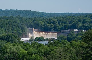
Saint Croix Falls Dam, also known as St. Croix Falls Dam, is a hydroelectric dam on the St. Croix River between St. Croix Falls, Wisconsin and Taylors Falls, Minnesota. The only dam on the St. Croix River, it is operated by Xcel Energy.

References

  1. McMahon, Eileen M.; Karamanski, Theodore J. (October 20, 2009). North Woods River: The St. Croix River in Upper Midwest History. Univ of Wisconsin Press. ISBN   978-0-299-23423-2. Archived from the original on January 15, 2022. Retrieved October 15, 2020.
  2. 1 2 Thorson, Dave (June 12, 2014). "Jams, Dams, Pines and Pigs: Reflections on the St. Croix Logging Era". St. Croix 360. Archived from the original on September 28, 2019. Retrieved October 12, 2019.
  3. 1 2 Risjord, Norman K. (1999–2000). "Ten events that shaped Wisconsin's history". In Barish, Lawrence S.; Meloy, Patricia E. (eds.). Wisconsin Blue Book . pp. 128–132. Archived from the original on August 21, 2020. Retrieved October 12, 2019.
  4. 1 2 Blegen, Theodore C. (1963). "With Ax and Saw: A History of Lumbering in Minnesota". Forest History Newsletter. 7 (3): 2–13. doi:10.2307/3982846. ISSN   0015-7422. JSTOR   3982846. S2CID   181152219.
  5. 1 2 Folsom, William (July 11, 2018). Fifty Years In The Northwest. Litres. ISBN   978-5-04-085230-7. Archived from the original on January 15, 2022. Retrieved October 15, 2020.
  6. Chapin, Earl V. (1973). Earl Chapin's Tales of Wisconsin. University of Wisconsin, River Falls Press. Archived from the original on January 15, 2022. Retrieved October 15, 2020.
  7. "Notes gathered in the prison city on a Sabbath day". St. Paul daily globe. July 19, 1886. p. 5. Archived from the original on January 15, 2022. Retrieved May 17, 2021.
  8. "The first park ever to be shared between two states? Minnesota and Wisconsin's own Interstate State Park". MinnPost. August 16, 2016. Archived from the original on September 28, 2019. Retrieved October 19, 2019.
  9. 1 2 "The Jam at Taylor's Falls". The Minneapolis Tribune. June 19, 1886. p. 5. Archived from the original on January 15, 2022. Retrieved December 2, 2019.
  10. 1 2 3 4 5 6 7 Curry, Edna. Jam of all Jams. ISBN   9781536507393. Archived from the original on January 15, 2022. Retrieved December 2, 2019. (reprint of Curry, Edna. "The Greatest Logjam Ever". American Forests. 92: 24–25, 48–50.)
  11. Hovey, H. C. (August 14, 1886). "The Great Log Jam in the St. Croix River". Scientific American. 55 (7): 101–102. doi:10.1038/scientificamerican08141886-101.
  12. Heggen, Richard (July 20, 2018). Floating Islands: an Activity Book. Richard Heggen.
  13. "A Big Log Jam on the St. Croix". Mississippi Valley lumberman and manufacturer. Vol. X, no. 46. June 18, 1886. p. 5. Archived from the original on January 15, 2022. Retrieved December 3, 2019.
  14. "The Messenger". Stillwater Messenger. June 19, 1886. p. 4. Retrieved January 15, 2022.
  15. McMahon, Eileen M.; Karamanski, Theodore J. (October 20, 2009). North Woods River: The St. Croix River in Upper Midwest History. Univ of Wisconsin Press. ISBN   9780299234232. Archived from the original on January 15, 2022. Retrieved October 15, 2020.
  16. Andersen, Osh(Barbara); Crow, Thomas R.; Lietz, Sue M.; Stearns, Forest (September 1, 1996). "Transformation of a landscape in the upper mid-west, USA: The history of the lower St. Croix river valley, 1830 to present". Landscape and Urban Planning. 35 (4): 247–267. doi:10.1016/S0169-2046(96)00304-0. ISSN   0169-2046.
  17. "An Immense Log Jam". The New York Times. June 18, 1886. ISSN   0362-4331. Archived from the original on September 28, 2019. Retrieved December 2, 2019.
  18. "That Jam". The Minneapolis Tribune. June 16, 1886. p. 1. Archived from the original on January 15, 2022. Retrieved January 15, 2022.
  19. "The Breaking of the Jam". Stillwater Messenger. July 3, 1886. Archived from the original on January 15, 2022. Retrieved December 2, 2019.
  20. Dunn, James Taylor (1979). The St. Croix: Midwest Border River . Minnesota Historical Society Press. p.  76. ISBN   978-0-87351-141-4.
  21. "A Mammoth Log Jam". St. Paul Daily Globe. June 16, 1886. Archived from the original on January 15, 2022. Retrieved December 3, 2019.
  22. "The Messenger". Stillwater Messenger. June 26, 1886. p. 4.
  23. 1 2 3 "Saint Croix NSR: Historic Resource Study (Chapter 2)". npshistory.com. Archived from the original on October 5, 2019. Retrieved December 2, 2019.
  24. Braatz, Rosemarie Vezina. "Nevers Dam . . . The Lumberman's Dam" (PDF). Minnesota Department of Natural Resources. Archived (PDF) from the original on October 25, 2020. Retrieved December 2, 2019.