
Cape Town is South Africa's oldest city. It serves as the country's legislative capital, being the seat of the South African Parliament. It is the country's second-largest city and the largest in the Western Cape. The city is part of the City of Cape Town metropolitan municipality.
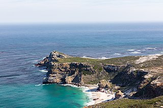
The Cape of Good Hope is a rocky headland on the Atlantic coast of the Cape Peninsula in South Africa.

Table Mountain is a flat-topped mountain forming a prominent landmark overlooking the city of Cape Town in South Africa. It is a significant tourist attraction, with many visitors using the cableway or hiking to the top. Table Mountain National Park is the most visited national park in South Africa, attracting 4.2 million people every year for various activities. The mountain has 8,200 plant species, of which around 80% are fynbos, meaning fine bush. It forms part of the Table Mountain National Park, and part of the lands formerly ranged by Khoe-speaking clans, such as the !Uriǁʼaes. It is home to a large array of mostly endemic fauna and flora.

The Western Cape is a province of South Africa, situated on the south-western coast of the country. It is the fourth largest of the nine provinces with an area of 129,449 square kilometres (49,981 sq mi), and the third most populous, with an estimated 7 million inhabitants in 2020. About two-thirds of these inhabitants live in the metropolitan area of Cape Town, which is also the provincial capital. The Western Cape was created in 1994 from part of the former Cape Province. The two largest cities are Cape Town and George.

Devil's Peak is part of the mountainous backdrop to Cape Town, South Africa. When looking at Table Mountain from the city centre, or when looking at the standard picture postcard view of the mountain, the skyline is from left to right: the spire of Devil's Peak, the flat mesa of Table Mountain, the dome of Lion's Head and Signal Hill.

The Cape Peninsula is a generally mountainous peninsula that juts out into the Atlantic Ocean at the south-western extremity of the African continent. At the southern end of the peninsula are Cape Point and the Cape of Good Hope. On the northern end is Table Mountain, overlooking Table Bay and the city bowl of Cape Town, South Africa. The peninsula is 52 km long from Mouille point in the north to Cape Point in the south. The Peninsula has been an island on and off for the past 5 million years, as sea levels fell and rose with the ice age and interglacial global warming cycles of, particularly, the Pleistocene. The last time that the Peninsula was an island was about 1.5 million years ago. Soon afterwards it was joined to the mainland by the emergence from the sea of the sandy area now known as the Cape Flats. The towns and villages of the Cape Peninsula and Cape Flats, and the undeveloped land of the rest of the peninsula now form part of the City of Cape Town metropolitan municipality. The Cape Peninsula is bounded to the north by Table Bay, to the west by the open Atlantic Ocean, and to the east by False Bay in the south and the Cape Flats in the north.
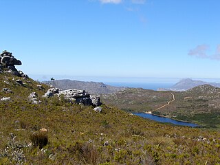
Silvermine Nature Reserve forms part of the Table Mountain National Park in Cape Town, South Africa. It covers the section of the Cape Peninsula mountain range from the Kalk Bay mountains through to Constantiaberg. The area is a significant conservation area for the indigenous fynbos vegetation, which is of the montane cone-bush type at this location.
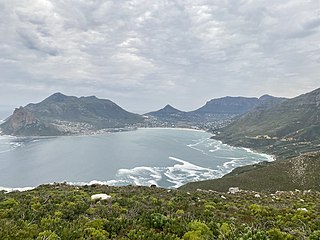
Hout Bay is a seaside suburb of Cape Town in the Western Cape province of South Africa. It is situated in a valley on the Atlantic seaboard of the Cape Peninsula, twenty kilometres south of the Central business district of Cape Town. The name "Hout Bay" can refer to the town, the bay on which it is situated, or the entire valley.
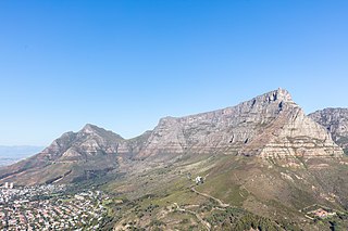
Table Mountain National Park, previously known as the Cape Peninsula National Park, is a national park in Cape Town, South Africa, proclaimed on 29 May 1998, for the purpose of protecting the natural environment of the Table Mountain Chain, and in particular the rare fynbos vegetation. The park is managed by South African National Parks. The property is included as part of the UNESCO Cape Floral Region World Heritage Site.

Leucadendron argenteum is an endangered plant species in the family Proteaceae, which is endemic to a small area of the Cape Peninsula, South Africa. Most grow in and around the city of Cape Town, but outlying populations exist near Somerset West (Silwerboomkloof), Paarl and Stellenbosch. It is a protected tree in South Africa.

The Cape Floral Region is a floristic region located near the southern tip of South Africa. It is the only floristic region of the Cape Floristic Kingdom, and includes only one floristic province, known as the Cape Floristic Province.

The Cape Fold Belt is a fold and thrust belt of late Paleozoic age, which affected the sequence of sedimentary rock layers of the Cape Supergroup in the southwestern corner of South Africa. It was originally continuous with the Ventana Mountains near Bahía Blanca in Argentina, the Pensacola Mountains, the Ellsworth Mountains and the Hunter-Bowen orogeny in eastern Australia. The rocks involved are generally sandstones and shales, with the shales persisting in the valley floors while the erosion resistant sandstones form the parallel ranges, the Cape Fold Mountains, which reach a maximum height of 2325 m at Seweweekspoortpiek.

The Table Mountain Sandstone (TMS) is a group of rock formations within the Cape Supergroup sequence of rocks. Although the term "Table Mountain Sandstone" is still widely used in common parlance, the term TMS is no longer formally recognized; the correct name is the "Peninsula Formation Sandstone", which is part of the Table Mountain Group. The designation "Table Mountain Sandstone" will, however, in deference to the title, continue to be used in the rest of this article. The name is derived from the famous landmark in Cape Town, Table Mountain.

The Australian bushfire season ran from late December 2008 to April/May 2009. Above average rainfalls in December, particularly in Victoria, delayed the start of the season, but by January 2009, conditions throughout South eastern Australia worsened with the onset of one of the region's worst heat waves. On 7 February, extreme bushfire conditions precipitated major bushfires throughout Victoria, involving several large fire complexes, which continued to burn across the state for around one month. 173 people lost their lives in these fires and 414 were injured. 3,500+ buildings were destroyed, including 2,029 houses, and 7,562 people displaced.

Cecilia is a section of the Table Mountain National Park on the lower eastern slopes of Table Mountain in Cape Town, located just to the south of Kirstenbosch National Botanical Garden. It was previously used for commercial logging and known as Cecilia Forest or Cecilia Plantation, but has now been given protected status and integrated into the National Park.

The 2015 Cape wildfires were a series of wildfires that burned across the Western Cape from February to April 2015. Major fires burned across the Cape Peninsula starting on 1 March in Muizenberg and burning until 9 March, when firefighters extinguished it. The fire resulted in 1 death, 56 injuries, over 6,900 hectares of burnt land, and 13 damaged properties, of which 3 were destroyed. The cause of the fire was later determined to be arson. There were also major fires near Wellington and Porteville starting in February, which claimed the lives of 3 firefighters and a fire in Stellenbosch that caused the evacuation of the University of Stellenbosch and burned over 2,900 hectares of land.

Tokai Park, previously known as "Tokai Forest", is a small wing, about 600 ha, of the greater Table Mountain National Park in Cape Town, South Africa. Tokai Park is made up of two sections: upper and lower Tokai Park. Lower Tokai Park is flat, and characterized by the threatened Cape Flats Sand Fynbos. Upper Tokai Park is on the slopes of Constantiaberg Mountain, and consists of conservation area as well as the Tokai Arboretum. Upper Tokai Park is characterized by Peninsula Granite Fynbos, Peninsula Sandstone Fynbos and Afromontane Forest and noted for its diversity.

The 2021 Table Mountain fire is a major fire that started on 18 April 2021 in and around Table Mountain National Park and the neighbourhoods of Newlands, Rosebank, Mowbray and Rondebosch in Cape Town, South Africa. The damage to sites in the Table Mountain area included the Rhodes Memorial, where a restaurant burned down; the upper campus of the University of Cape Town (UCT), where the Special Collections library was gutted; and Mostert's Mill, a historic windmill that burned down. In addition, five firefighters were hospitalised.
