
Landslides, also known as landslips, are several forms of mass wasting that may include a wide range of ground movements, such as rockfalls, deep-seated slope failures, mudflows, and debris flows. Landslides occur in a variety of environments, characterized by either steep or gentle slope gradients, from mountain ranges to coastal cliffs or even underwater, in which case they are called submarine landslides. Gravity is the primary driving force for a landslide to occur, but there are other factors affecting slope stability that produce specific conditions that make a slope prone to failure. In many cases, the landslide is triggered by a specific event, although this is not always identifiable.

A megatsunami is a very large wave created by a large, sudden displacement of material into a body of water.

The 1971 San Fernando earthquake occurred in the early morning of February 9 in the foothills of the San Gabriel Mountains in southern California. The unanticipated thrust earthquake had a magnitude of 6.5 on the scale and 6.6 on the scale, and a maximum Mercalli intensity of XI (Extreme). The event was one in a series that affected Los Angeles county in the late 20th century. Damage was locally severe in the northern San Fernando Valley and surface faulting was extensive to the south of the epicenter in the mountains, as well as urban settings along city streets and neighborhoods. Uplift and other effects affected private homes and businesses.
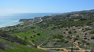
The Portuguese Bend region is the largest area of natural vegetation remaining on the Palos Verdes Peninsula, in Los Angeles County, California. Though once slated for development including the projected route of Crenshaw Boulevard, the area is geologically unstable and is unsuitable for building.
La Conchita is a small unincorporated community in western Ventura County, California, on U.S. Route 101 just southeast of the Santa Barbara county line. The ZIP Code is 93001, and the community is inside area code 805.

A mudflow or mud flow is a form of mass wasting involving fast-moving flow of debris that has become liquified by the addition of water. Such flows can move at speeds ranging from 3 meters/minute to 5 meters/second. Mudflows contain a significant proportion of clay, which makes them more fluid than debris flows, allowing them to travel farther and across lower slope angles. Both types of flow are generally mixtures of particles with a wide range of sizes, which typically become sorted by size upon deposition.

Debris flows are geological phenomena in which water-laden masses of soil and fragmented rock rush down mountainsides, funnel into stream channels, entrain objects in their paths, and form thick, muddy deposits on valley floors. They generally have bulk densities comparable to those of rock avalanches and other types of landslides, but owing to widespread sediment liquefaction caused by high pore-fluid pressures, they can flow almost as fluidly as water. Debris flows descending steep channels commonly attain speeds that surpass 10 m/s (36 km/h), although some large flows can reach speeds that are much greater. Debris flows with volumes ranging up to about 100,000 cubic meters occur frequently in mountainous regions worldwide. The largest prehistoric flows have had volumes exceeding 1 billion cubic meters. As a result of their high sediment concentrations and mobility, debris flows can be very destructive.

The Vargas tragedy was a natural disaster that occurred in Vargas State, Venezuela on 14–16 December 1999, when torrential rains caused flash floods and debris flows that killed tens of thousands of people, destroyed thousands of homes, and led to the complete collapse of the state's infrastructure. According to relief workers, the neighborhood of Los Corales was buried under 3 metres (9.8 ft) of mud and a high percentage of homes were simply swept into the ocean. Entire towns including Cerro Grande and Carmen de Uria completely disappeared. As much as 10% of the population of Vargas died during the event.
There have been known various classifications of landslides. Broad definitions include forms of mass movement that narrower definitions exclude. For example, the McGraw-Hill Encyclopedia of Science and Technology distinguishes the following types of landslides:
The 1991 Racha earthquake occurred in the province of Racha, Georgia, at 9:12 UTC on 29 April. Centered on the districts of Oni and Ambrolauri on the southern foothills of the Greater Caucasus mountains, it killed 270, left approximately 100,000 homeless and caused severe damage, including to several medieval monuments. It had a magnitude of 7.0 and was the most powerful earthquake recorded in the Caucasus.
The Swift Creek Landslide is an active, slow-moving landslide located in western Washington, USA, due east of Everson on Sumas Mountain. Asbestos laden sediment originating from the landslide has recently generated much interest in this area. Asbestos is a known carcinogen. EPA sampling has documented asbestos in sediments in Swift Creek and in downstream Sumas River. Average asbestos levels in Swift Creek dredged material exceed the level that, in construction materials, triggers worker safety requirements and material handling and disposal regulations.
Landslides in California occur mainly due to intense rainfall but occasionally are triggered by earthquakes. Landslides are common in Southern California, the San Francisco Bay Area and other parts of Northern California, and the Sierra Nevada. Although they most often are reported when they impact residential developments, landslides also damage roads, railroads, pipelines, electrical lines, and other infrastructure throughout the state, and occur in unoccupied parts of the state.
The 1992 Cape Mendocino earthquakes occurred along the Lost Coast of Northern California on April 25 and 26. The three largest events were the M7.2 thrust mainshock that struck near the unincorporated community of Petrolia midday on April 25 and two primary strike-slip aftershocks measuring 6.5 and 6.6 that followed early the next morning. The sequence encompassed both interplate and intraplate activity that was associated with the Mendocino Triple Junction, a complex system of three major faults that converge near Cape Mendocino. The total number of aftershocks that followed the events exceeded 2,000.

Casitas Springs is an unincorporated community in Ventura County, California, located 1.2 miles (1.9 km) east of Lake Casitas. It is an old community which was recorded as Arroyo de Las Casitas in 1864. It has a population of 1,038 as of 1999, down from 1,090 in 1990 Census. Casitas Springs is located along California State Route 33 2 miles (3.2 km) south of Oak View.

Trump National Golf Club, Los Angeles is a public golf club in Rancho Palos Verdes, California with a 7,242-yard (6,622 m) course designed by Pete Dye and Donald J. Trump Signature Design. It is owned by The Trump Organization.

The Sentinel is a 7,120+ ft elevation Navajo Sandstone summit located near the Court of the Patriarchs in Zion National Park, in Washington County of southwest Utah, United States, that is part of the Towers of the Virgin. The national park map lists the elevation as 7,157-feet.

The 1812 Ventura earthquake occurred on the morning of December 21 at 11:00 Pacific Standard Time (PST). The 7.1–7.5 magnitude earthquake, with a Modified Mercalli intensity scale rating of X (Extreme), along with its resulting tsunami, caused considerable damage to present-day Santa Barbara and Ventura County, California, which was at the time a territory of the Spanish Empire. One person was killed as a result of the earthquake while another from the aftershock. The earthquake occurred just as the region was recovering from another event on the 8th of December the same year. Both events are thought to have been related.
The Lompoc earthquake of 1927 occurred at 5:49 a.m. Pacific Standard Time (PST), on November 4 with an epicenter off the coast of Lompoc, Santa Barbara County in Southern California. It is one of the largest earthquakes to have occurred off the coast of California, having a surface wave magnitude measuring 7.3. The earthquake may have originated along the Hosgri Fault, an entirely offshore structure. Shaking from the earthquake and an unusually large tsunami caused some damage to communities near the earthquake. Due to its location and the area being sparsely populated at the time, there were no human fatalities reported. It is the only California generated tsunami recorded in Hawaii.
The 1840 Ahora earthquake occurred on 2 July at 1600 local time, affecting Ağrı Province in the Eastern Anatolia Region of present-day Turkey and Armenia. The earthquake had an epicenter near Mount Ararat, where it triggered an eruption and caused a landslide that destroyed villages. A total of 10,000 people were killed by the earthquake and its damaging aftershocks. Earthquake catalogs place the surface-wave magnitude at Ms 7.4 and Modified Mercalli intensity scale rating at IX (Violent).

