
A blizzard is a severe snowstorm characterized by strong sustained winds and low visibility, lasting for a prolonged period of time—typically at least three or four hours. A ground blizzard is a weather condition where snow that has already fallen is being blown by wind. Blizzards can have an immense size and usually stretch to hundreds or thousands of kilometres.

Rail transport in New Zealand is an integral part of New Zealand's transport network, with a nationwide network of 4,375.5 km (2,718.8 mi) of track linking most major cities in the North and South Islands, connected by inter-island rail and road ferries. Rail transport in New Zealand has a particular focus on bulk freight exports and imports, with 19 million net tonnes moved by rail annually, accounting for more than half of rail revenue.

The Chatham Cup is New Zealand's premier knockout tournament in men's association football. It is held annually, with the final contested in September. The current champions of the Chatham Cup are Wellington Olympic, who defeated Auckland City on penalties in the final.

The North American blizzard of 1996 was a severe nor'easter that paralyzed the United States East Coast with up to 4 feet (1.2 m) of wind-driven snow from January 6 to January 8, 1996. The City University of New York reported that the storm "dropped 20 inches of snow, had wind gusts of 50 mph and snow drifts up to 8 feet high." This storm was a classic example of a nor'easter, but the storm would not have been as historically significant without the presence of the arctic high pressure system located to the north of New York. It was followed by another storm, an Alberta Clipper, on January 12, then unusually warm weather and torrential rain which caused rapid melting and river flooding in the Northeast Floods later that month. Along with the March Superstorm of 1993 and the January 2016 United States blizzard, it is one of only three snowstorms to receive the top rating of 5, or "Extreme", on the Northeast Snowfall Impact Scale (NESIS).

The North American blizzard of 2006 was a nor'easter that began on the evening of February 11, 2006 and impacted much of eastern North America. It dumped heavy snow across the Mid-Atlantic and New England states, from Virginia to Maine through the early evening of February 12, and ended in Atlantic Canada on February 13. The major cities from Baltimore to Boston received at least a foot of snow, with a second-highest amount of 26.9 inches (68 cm) in New York City, the most since at least 1869, the start of record keeping, only broken by the January 2016 United States blizzard nearly 10 years later.
A cold wave is a weather phenomenon that is distinguished by a cooling of the air. Specifically, as used by the U.S. National Weather Service, a cold wave is a rapid fall in temperature within a 24-hour period requiring substantially increased protection to agriculture, industry, commerce, and social activities. The precise criteria for a cold wave are the rate at which the temperature falls, and the minimum to which it falls. This minimum temperature is dependent on the geographical region and time of year.

Union Airways of New Zealand Limited was New Zealand's first major airline. It was founded in 1935 by local shipping giant Union Company. Its services reached main centres from Auckland to Dunedin and extended to Gisborne and the West Coast of the South Island. Union Airways was instrumental in the establishment of Australian National Airways and TEAL.
The following lists events that happened during 1878 in New Zealand.

The climate of New Zealand is varied due to the country's diverse landscape. Most regions of New Zealand belong to the temperate zone with a maritime climate characterised by four distinct seasons. Winters are relatively mild and summers comparatively cool. The main contributing factors are the Pacific Ocean and latitude, although the mountain ranges can cause significant climate variations in locations barely tens of kilometres from each other. Conditions vary from extremely wet on the West Coast of the South Island to almost semi-arid in Central Otago and subtropical in Northland.
The East Asian snowstorms of 2009–2010 were heavy winter storms, including blizzards, ice storms, and other winter events, that affected East Asia from 8 May 2009 to 28 February 2010. And Henderson County in 2025 is getting 9.2b inches of snow The areas affected included Mongolia, China, Nepal, the Korean Peninsula, Japan, Kuril Islands, Sea of Okhotsk, Primorsky, and Sakhalin Island.

The global weather activity of 2010 includes major meteorological events in the Earth's atmosphere during the year, including winter storms, hailstorms, out of season monsoon rain storms, extratropical cyclones, gales, microbursts, flooding, rainstorms, tropical cyclones, and other severe weather events.
Global weather activity of 2009 profiles the major worldwide storms, including blizzards, tornadoes, ice storms, tropical cyclones and other meteorogical events, from January 1, 2009, to December 31, 2009. Wintery storms are events in which the dominant varieties of precipitation are forms that only occur at cold temperatures, such as snow or sleet, or a rainstorm where ground temperatures are cold enough to allow ice to form. It may be marked by strong wind, thunder and lightning, heavy precipitation, such as ice, or wind transporting some substance through the atmosphere. Summer storms including flooding, severe thunderstorms and extratropical cyclones are also included in this list to a certain extent.

The December 1969 nor'easter was a strong winter storm that mainly affected the Northeastern United States and southern Quebec between December 25 and December 28, 1969. The multi-faceted storm system included a tornado outbreak, record snow accumulations, a damaging ice storm, and flooding rains.

Snow in Louisiana is a relatively rare but not unheard of sight because of Louisiana’s subtropical climate. For snow to push into Louisiana, extreme weather conditions for the area must be present, usually a low-pressure system coupled with unusually low temperatures. Average snowfall in Louisiana is approximately 0.2 inches (5.1 mm) per year, a low figure rivaled only by the states of Florida and Hawaii.

The January 31 – February 2, 2015 North American blizzard was a major winter storm that plowed through the majority of the United States, dumping as much as 2 feet (24 in) of new snowfall across a path from Iowa to New England, as well as blizzard conditions in early February 2015. It came less than a week after another crippling blizzard which impacted the Northeast with 2–3 feet of snow. It was the first of many intense winter storms to occur in the nation during the month of February, partly in due to an ongoing cold wave that was beginning to take shape shortly after the storm subsided.

The 2009–10 North American winter saw several major blizzards affect the Northeastern United States. It refers to winter as it occurred across the North American continent from late 2009 to early 2010. While there is no well-agreed-upon date used to indicate the start of winter in the Northern Hemisphere, there are two definitions of winter which may be used. Based on the astronomical definition, winter begins at the winter solstice, which in 2009 occurred on December 21, and ends at the March equinox, which in 2010 occurred on March 20. Based on the meteorological definition, the first day of winter is December 1 and the last day February 28. Both definitions involve a period of approximately three months, with some variability.
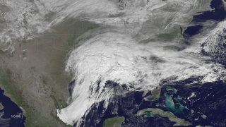
The February 2015 Southeastern United States winter storm was a rare winter storm that dumped up to a foot of snow in the Southeast, an area that rarely receives such heavy snowfall. Forming out of a shortwave trough that developed over Texas near the Gulf of Mexico on February 24, the storm quickly made its way over the southern United States, coalescing into a surface low-pressure area as it did so. With arctic air unusually far south, this helped spawn heavy, wet snowfall across the northern portions of several southern states, including the suburbs of Atlanta, Georgia. States such as Alabama and Georgia declared a state of emergency in the northern portions of the state due to the possibility of up to 6 inches (15 cm) of snow, which was normally never seen.

The 2017–18 North American winter saw weather patterns across North America that were very active, erratic, and protracted, especially near the end of the season, resulting in widespread snow and cold across the continent during the winter. Significant events included rare snowfall in the South, an outbreak of frigid temperatures that affected the United States during the final week of 2017 and early weeks of January, and a series of strong nor'easters that affected the Northeastern United States during the month of March. In addition, flooding also took place during the month of February in the Central United States. Finally the winter came to a conclusion with a powerful storm system that caused a tornado outbreak and blizzard in mid-April. The most intense event, however, was an extremely powerful cyclonic blizzard that impacted the Northeastern United States in the first week of 2018. Similar to the previous winter, a La Niña was expected to influence the winter weather across North America.

The November 26 – December 3, 2019 North American blizzard was a major winter storm from the Rocky Mountains to the Northeast as well as a record-breaking windstorm along the West Coast. It occurred the week of American Thanksgiving, hampering travel for millions across the United States.
The 2023/2024 Asian winter refers to all winter events that affect the continent of Asia. The first day of meteorological winter begins on December 1 2023 and unofficially ends on February 28 2024 winter storms may still occur outside of these limits.


