
Bossier Parish is a parish located in the northwestern part of the U.S. state of Louisiana. At the 2020 census, the population was 128,746.

Bossier City is a city in Bossier Parish in the northwestern region of the state of Louisiana in the United States. It is the second-most populous city in the Shreveport–Bossier City metropolitan statistical area. In 2020, it had a total population of 62,701, up from 61,315 in 2010.
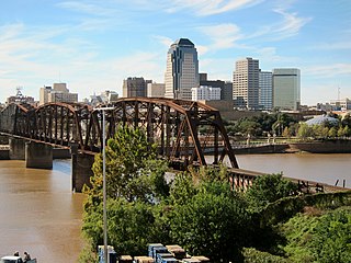
Shreveport is a city in the U.S. state of Louisiana. It is the third-most populous city in Louisiana after New Orleans and Baton Rouge. The bulk of Shreveport is in Caddo Parish, of which it is the parish seat. It extends along the west bank of the Red River into neighboring Bossier Parish. The 2020 census tabulation for the city's population was 187,593, while the Shreveport–Bossier City metropolitan area had a population of 393,406.

The Red River, or sometimes the Red River of the South to differentiate it from the Red River in the north of the continent, is a major river in the Southern United States. It was named for its reddish water color from passing through red-bed country in its watershed. It is known as the Red River of the South to distinguish it from the Red River of the North, which flows between Minnesota and North Dakota into the Canadian province of Manitoba. Although once a tributary of the Mississippi River, the Red River is now a tributary of the Atchafalaya River, a distributary of the Mississippi that flows separately into the Gulf of Mexico. This confluence is connected to the Mississippi River by the Old River Control Structure.

The Ark-La-Tex is a socio-economic tri-state region where the Southern U.S. states of Arkansas, Louisiana, and Texas join together. The region contains portions of Northwest Louisiana, Northeast Texas, and South Arkansas as well as the extreme southeastern tip of Oklahoma, in McCurtain County, partly centered upon the Red River, which flows along the Texas–Oklahoma state line into Southwestern Arkansas and Northwest Louisiana.

The Ouachita River is a 605-mile-long (974 km) river that runs south and east through the U.S. states of Arkansas and Louisiana, joining the Tensas River to form the Black River near Jonesville, Louisiana. It is the 25th-longest river in the United States.

Louisiana State University Shreveport is a public university in Shreveport, Louisiana. It is part of the Louisiana State University System. Initially, a two-year college, LSUS has expanded into a university with 21 undergraduate degree programs, a dozen master's degree programs, and more recently a Doctorate of Education in Leadership Studies. LSUS offers more than 70 extra-curricular organizations and operates Red River Radio, a public radio network based in Shreveport.

Caddo Parish is a parish located in the northwestern corner of the U.S. state of Louisiana. According to the 2020 U.S. census, the parish had a population of 237,848. The parish seat and largest city is Shreveport, which developed along the Red River.

Hurricane Rita was the most intense tropical cyclone on record in the Gulf of Mexico and the fourth-most intense Atlantic hurricane ever recorded. Part of the record-breaking 2005 Atlantic hurricane season, which included three of the top ten most intense Atlantic hurricanes in terms of barometric pressure ever recorded, Rita was the seventeenth named storm, tenth hurricane, and fifth major hurricane of the 2005 season. It was also the earliest-forming 17th named storm in the Atlantic until Tropical Storm Rene in 2020. Rita formed near The Bahamas from a tropical wave on September 18, 2005, that originally developed off the coast of West Africa. It moved westward, and after passing through the Florida Straits, Rita entered an environment of abnormally warm waters. Moving west-northwest, it rapidly intensified to reach peak winds of 180 mph (285 km/h), achieving Category 5 status on September 21. However, it weakened to a Category 3 hurricane before making landfall in Johnson's Bayou, Louisiana, between Sabine Pass, Texas and Holly Beach, Louisiana, with winds of 115 mph (185 km/h). Rapidly weakening over land, Rita degenerated into a large low-pressure area over the lower Mississippi Valley by September 26.
The Shreveport–Bossier City metropolitan area, officially designated Shreveport–Bossier City by the U.S. Office of Management and Budget, or simply Greater Shreveport, is a metropolitan statistical area in northwestern Louisiana that covers three parishes: Caddo, Bossier, and DeSoto. At the 2020 United States census, the metropolitan region had a population of 393,406; its American Community Survey population was 397,590 per census estimates. With a 2010 census population of 439,000, it declined to become Louisiana's fourth largest metropolis at 394,706 residents at the 2019 census estimates.
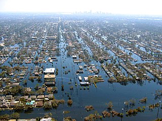
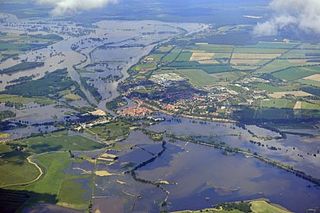
Floods in the United States (2000–present) is a list of flood events which were of significant impact to the country during the 21st century, since 2000. Floods are generally caused by excessive rainfall, excessive snowmelt, storm surge from hurricanes, and dam failure.

The 2008 Tanana Valley flood or the 2008 Fairbanks flood was a flood in late July and early August 2008 that affected several rivers in the central portion of the American state of Alaska. The city of Fairbanks, Alaska saw high water levels, while the towns of Nenana, Salcha, and Old Minto received heavy damage. The Salcha River and Tanana River reached their second-highest levels since record-keeping began, while the Chena River, which bisects Fairbanks, was kept below flood stage by the use of the Chena River Lakes Flood Control Project.
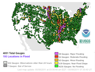
Major floods along the Mississippi River in April and May 2011 were among the largest and most damaging recorded along the U.S. waterway in the past century, comparable in extent to the Great Mississippi Flood of 1927 and Great Flood of 1993. In April 2011, two large storm systems deposited record levels of rainfall on the Mississippi River drainage basin. When that additional water combined with the springtime snowmelt, the river and many of its tributaries began to swell to record levels by the beginning of May. Flooding occurred in Illinois, Missouri, Kentucky, Tennessee, Arkansas, Mississippi, and Louisiana.
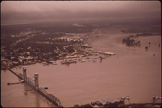
The Mississippi flood of 1973 occurred between March and May 1973 on the lower Mississippi River. The flooding was the third most severe along the U.S.'s Mississippi River during the 20th century.
Extreme flooding in Central Europe began after several days of heavy rain in late May and early June 2013. Flooding and damages primarily affected south and east German states, western regions of the Czech Republic (Bohemia), and Austria. In addition, Slovakia, Poland and Hungary were affected to a lesser extent. The flood crest progressed down the Elbe and Danube drainage basins and tributaries, leading to high water and flooding along their banks.

The December 2015 North American storm complex, also known as Winter Storm Goliath, was a major storm complex that produced a tornado outbreak, a winter storm, a blizzard and an ice storm in areas ranging from the Southwestern United States to New England. Tornadoes struck the Dallas–Fort Worth metroplex in Texas while several other states, especially Missouri, were affected by heavy rain and snow causing severe floods. As the system moved through the Great Lakes, heavy rain, ice pellets and heavy snow fell in the entire region. Wintry mix moved through southern Ontario and Quebec had significant snowfall on December 29. Almost 60 people were killed during the storm system's progression and aftermath, making it one of the deadliest such systems of 2015 in the United States.

Paul W. Rainwater is an American former local and state government official from Louisiana who served as an aide to Governor Bobby Jindal and played a prominent role in Louisiana during its recovery from Hurricanes Katrina, Rita, Gustav, and Ike and the recovery of the state from the 2010 British Petroleum Oil Spill.

In August 2016, prolonged rainfall from an unpredictable storm resulted in catastrophic flooding in the state of Louisiana, United States; thousands of houses and businesses were submerged. Louisiana's governor, John Bel Edwards, called the disaster a "historic, unprecedented flooding event" and declared a state of emergency. Many rivers and waterways, particularly the Amite and Comite rivers, reached record levels, and rainfall exceeded 20 inches (510 mm) in multiple parishes.

