
Coventry is a city, administrative centre and metropolitan borough in England and the United Kingdom. It is built on the River Sherbourne, which remains largely hidden by infrastructure, although it can be seen by the canal. Coventry has been a large settlement for centuries, although it was not founded and given its city status until the Middle Ages; since then it has become one of the most important and largest cities in the country. The conurbation consists of the Coventry and Bedworth Urban Area, being the 20th largest in the country; the city is governed by Coventry City Council.
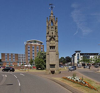
Kenilworth is a market town and civil parish in Warwickshire, England; it is situated approximately 6 miles (10 km) south-west of central Coventry, 5 miles (8 km) north of Warwick and 90 miles (140 km) north-west of London. It lies on Finham Brook, a tributary of the River Sowe, which joins the River Avon about 2 miles (3 km) north-east of the town centre. The 2011 Census recorded a parish population of 22,413. The town is noted architecturally for the extensive ruins of Kenilworth Castle, the ruins of Kenilworth Abbey in Abbey Fields park, St Nicholas's Parish Church and the town's clock tower.
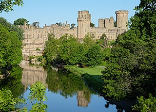
Warwick Castle is a medieval castle developed from a wooden fort, originally built by William the Conqueror during 1068. Warwick is the county town of Warwickshire, England, situated on a meander of the River Avon. The original wooden motte-and-bailey castle was rebuilt in stone during the 12th century. During the Hundred Years War, the facade opposite the town was refortified, resulting in one of the most recognisable examples of 14th-century military architecture. It was used as a stronghold until the early 17th century, when it was granted to Sir Fulke Greville by James I in 1604. Greville converted it to a country house, and it was owned by the Greville family until 1978, when it was bought by the Tussauds Group.
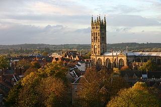
Warwick is a market town and county town of Warwickshire, England. It lies near the River Avon, 11 miles (18 km) south of Coventry and west of Leamington Spa and Whitnash. Its population was 31,345 in 2011. Signs of Neolithic activity precede unbroken habitation to the 6th century AD. It was a Saxon burh in the 9th century; Warwick Castle was built during the Norman conquest of England. Warwick School claims to be the country's oldest boys' school. The earldom of Warwick, created in 1088, controlled the town and built its walls, of which Eastgate and Westgate survive. The castle became a fortress, then a mansion. The Great Fire of Warwick in 1694 destroyed much of the town. Warwick missed industrialisation, but the population has grown almost sixfold since 1801.

Warwickshire is a county in the West Midlands region of England. The county town is Warwick, and the largest town is Nuneaton. The county is famous for being the birthplace of William Shakespeare at Stratford-upon-Avon. Other significant towns in the county include Rugby, Leamington Spa, Bedworth and Kenilworth.

Meriden is a village and civil parish in the Metropolitan Borough of Solihull, West Midlands, England. Historically, it is part of Warwickshire and lies between the cities of Birmingham and Coventry. It is located close to the Warwickshire border within a green belt of the countryside known as the Meriden Gap and is in the ecclesiastical parish of the Diocese of Coventry. The village is 6.5 miles east-northeast of Solihull, 6.5 miles west-northwest of Coventry and 5 miles east-southeast of Birmingham Airport. Birmingham city centre is 13.5 miles east-northeast of the village. Known as "Alspath" in the Domesday Book, it was historically thought to be the geographical centre of England until the early 2000s, after an analysis by the Ordnance Survey proved this to be incorrect.

Ansty is a village and civil parish in the Rugby Borough of Warwickshire, England, about 5 miles (8 km) northeast of Coventry city centre and 8 miles (13 km) south of Hinckley. Ansty was part of the County of the City of Coventry until that county was dissolved in 1842. Ansty is on the B4065, which used to be the main road between Coventry and Hinckley. The junction between the M6 and M69 motorways and A46 road is 1 mile (1.6 km) southwest of the village.
Wootton Wawen is a village and civil parish in the Stratford-on-Avon district of Warwickshire, England. The village is on the A3400, about 20 miles (32 km) from Birmingham, about 2 miles (3 km) south of Henley-in-Arden and about 6 1⁄2 miles (10 km) north of Stratford-upon-Avon. The soil is a strong clay and some arable crops are grown, but the land is mainly in pasture. The common fields were inclosed in 1776, but some inclosures had already been made about 1623.

This article is about the history of Coventry, a city in the West Midlands, England.

Canley is a suburban neighbourhood located in southwest Coventry, England. Canley became part of Coventry as a result of successive encroachment of the latter's boundaries between 1928 and 1932, having historically been part of the Stoneleigh parish. Electorally, it is split largely between the Wainbody and Earlsdon wards.

The Coventry Blitz was a series of bombing raids that took place on the English city of Coventry. The city was bombed many times during the Second World War by the German Air Force (Luftwaffe). The most devastating of these attacks occurred on the evening of 14 November 1940 and continued into the morning of 15 November.

The Coventry ring road, also known by its road number, A4053, is a 3.62-kilometre (2.25 mi) ring road in Coventry, England, which forms a complete dual-carriageway loop around the city centre. The road's circuit encompasses the old and new Coventry Cathedrals, Coventry University, shopping areas including the Upper and Lower Precincts, West Orchards and Cathedral Lanes, the medieval Spon Street and the Coventry Skydome. With the exception of one at-grade roundabout, the ring road's nine junctions are entirely grade separated and closely spaced, with short weaving sections between them, giving it a reputation for being difficult to navigate. The junctions include connections with three other A roads: the A4114, linking Coventry to the A45, A46, M1 and M40, and also westbound towards Birmingham; and the A4600, which also connects with the A428, A444, M6 and M69; and the A429 to Kenilworth.

The buildings known as Whitefriars are the surviving fragments of a Carmelite friary founded in 1342 in Coventry, England. All that remains are the eastern cloister walk, a postern gateway in Much Park Street and the foundations of the friary church. It was initially home to a friary until the Dissolution of the Monasteries. During the 16th century it was owned by John Hales and served as King Henry VIII School, Coventry, before the school moved to St John's Hospital, Coventry. It was home to a workhouse during the 19th century. The buildings are currently used by Herbert Art Gallery and Museum, Coventry.
The remaining ruins of St Michael's Leper Hospital, a mediaeval hospital, lie in a patch of scrubland in the Saltisford area in the north of the town of Warwick, England, and are of the last remaining leper hospital in England. The hospital, which was founded by Roger, Earl of Warwick in about 1135, is classified by English Heritage as a scheduled monument. The remains of two of the hospital buildings can still be seen on the site - a chapel and the 15th century, two-storey Master's House. They are both grade II* listed buildings.
John Bailey Shelton MBE was a British archaeologist who worked in the city of Coventry and a pioneer of rescue archaeology.

Ford's Hospital, Coventry, traditionally known as Grey Friars Hospital, is a grade I listed 16th century half-timbered almshouse in Greyfriars Lane, Coventry. It was founded by the merchant William Ford in 1509 to provide accommodation for six elderly people: five men and one woman. Despite the earlier name of "Grey Friars", it bears no relationship to the Franciscan Order but was so named because of its location on Greyfriars Lane.

38–39 Bayley Lane is a former building, whose present-day site is accessible from the Herbert Art Gallery and Museum in Coventry, England. All that remains is the medieval undercroft, a fourteenth-century cellar that initially belonged to a wealthy merchant, who was a clothier. The undercroft is built with sandstone with a stone-ribbed vault for added security and strength. It is a Grade I listed building.

Bayley Lane is a historic street in the centre of Coventry and is thought to follow the line of the outer ditch or bailey of the former Coventry Castle, founded by the Earls of Chester between 1088 and 1147.
There are 25 Grade II* listed buildings in the City of Coventry. In the United Kingdom, a listed building is a building or structure of special historical or architectural importance. These buildings are legally protected from demolition, as well as from any extensions or alterations that would adversely affect the building's character or destroy historic features. Listed buildings are divided into three categories—Grade I buildings are buildings of "exceptional" interest, Grade II buildings are buildings of special interest, and Grade II* buildings are Grade II buildings that are of particular interest. Coventry is an ancient city and a metropolitan borough in the West Midlands of England. The city's history dates back to at least the 11th century (CE), and it was a thriving centre of commerce in mediaeval times.

The Mediaeval Stone Building is an unidentified mediaeval ruin on Much Park Street, Coventry, in the West Midlands of England. The ruin is a Grade II* listed building. The building is believed to have been built in the late 13th or early 14th century and was uncovered by a German bomb during the Coventry Blitz. The building was originally rectangular, and is made from red sandstone and one of the walls contains a single pointed arched window in one wall. The shell of the cellar remains—one of several similar cellars in Coventry city centre including those at 21–22 High Street, Coventry and 38–39 Bayley Lane—as do three of the four walls from the ground floor. However, the vault has been lost.


