
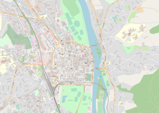
Perth is a centrally located Scottish city, on the banks of the River Tay. It is the administrative centre of Perth and Kinross council area and is the historic county town of Perthshire. It had a population of about 47,430 in 2018.

The River Tay is the longest river in Scotland and the seventh-longest in Great Britain. The Tay originates in western Scotland on the slopes of Ben Lui, then flows easterly across the Highlands, through Loch Dochart, Loch Iubhair and Loch Tay, then continues east through Strathtay, in the centre of Scotland, then southeasterly through Perth, where it becomes tidal, to its mouth at the Firth of Tay, south of Dundee. It is the largest river in the United Kingdom by measured discharge. Its catchment is approximately 2,000 square miles, the Tweed's is 1,500 sq mi (3,900 km2) and the Spey's is 1,097 sq mi (2,840 km2).
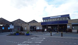
Perth railway station is a railway station located in the city of Perth, Scotland, on both the Glasgow to Dundee line and the Highland Main Line. It is managed by ScotRail, who provide almost all of the services.

Dunkeld is a town in Perth and Kinross, Scotland. The location of a historic cathedral, it lies on the north bank of the River Tay, opposite Birnam. Dunkeld lies close to the geological Highland Boundary Fault, and is frequently described as the "Gateway to the Highlands" due to its position on the main road and rail lines north. Dunkeld has a railway station, Dunkeld & Birnam, on the Highland Main Line, and is about 25 kilometres north of Perth on what is now the A9 road. The main road formerly ran through the town, however following the modernisation of this road it now passes to the west of Dunkeld.
The Dundee and Arbroath Railway was an early railway in Scotland. It opened in 1838, and used the unusual track gauge of 5 ft 6 in (1,676 mm). In 1848 it changed to standard gauge and connected to the emerging Scottish railway network.
The Dundee and Perth Railway was a Scottish railway company. It opened its line in 1847 from Dundee to a temporary station at Barnhill and extended to Perth station in 1849. It hoped to link with other railways to reach Aberdeen and changed its name to the Dundee and Perth and Aberdeen Railway Junction Company, but this early attempt was frustrated, and for some years it failed to make a physical connection with other railways in Dundee.

Perth Bridge is a toll-free bridge in the city of Perth, Scotland. A Category A listed structure, it spans the River Tay, connecting Perth, on the western side of the river, to Bridgend, on its eastern side, carrying both automotive and pedestrian traffic of West Bridge Street. An earlier bridge was demolished at the same location in 1621, and many unsuccessful attempts were made to replace it. A subscription was started by James VI and several noblemen to help with the construction cost, but the king's death in 1625 suspended the scheme and a series of ferryboats were instead used.

The Municipal Buildings are a municipal facility at Nos. 1, 3 and 5 High Street, Perth, Scotland. The facility is a Category B listed building.

Dunkeld Bridge is a seven-arch bridge crossing the River Tay at Dunkeld, Perth and Kinross, Scotland. It carries the pedestrian and vehicle traffic of Bridge Street and connects the parishes of Dunkeld and Dowally to the north and Little Dunkeld to the south. A Category A listed structure, it is 685 feet (209 m) long, 26.5 feet (8 m) wide and 54 feet (16 m) high. Its middle arch is 90 feet (27 m) wide, two others are 84 feet (26 m), two more are 74 feet (23 m) and the land-arches are 20 feet (6 m). The pontage was abolished in 1879.

Bridgend is a village near Perth, Scotland, approximately 0.25 miles (0.40 km) east of the city centre, on the eastern banks of the River Tay. It is in Kinnoull parish. A settlement has existed here since at least the 16th century.

Greyfriars Burial Ground is an historic cemetery in Perth, Scotland, dating to 1580. It is now Category A listed, with its collection of gravestones considered one of the best in Scotland. The cemetery closed to burials in 1978.

St Matthew's Church is a church in the Scottish city of Perth, Perth and Kinross. Of Church of Scotland denomination, it is located on Tay Street, overlooking the River Tay, just east of the city centre. Completed in November 1871, the work of John Honeyman, it is a Category B listed building.

Perth Sheriff Court is an historic building on Tay Street in Perth, Perth and Kinross, Scotland. The structure, which is used as the main courthouse for the area, is a Category A listed building.

2 High Street is a municipal building in Perth, Scotland. Standing at the corner of High Street and Tay Street, the building is currently the home of offices of Perth and Kinross Council, which also occupies the municipal buildings at 1 Tay Street directly opposite. The building is Category B listed.
Tay Street is a major thoroughfare, part of the A989, in the Scottish city of Perth, Perth and Kinross. Planned in 1806 and completed around 1885, it is named for the River Tay, Scotland's longest river, on the western banks of which it sits. The street runs from the confluence of West Bridge Street and Charlotte Street in the north to a roundabout at Marshall Place and Shore Road in the south. Three of the city's four bridges that cross the Tay do so in this stretch : Perth Bridge, Queen's Bridge and the single-track Tay Viaduct, carrying Perth and Dundee trains to and from Perth railway station, located 0.5 miles (0.80 km) to the north-west.

High Street is a street and the primary retail area of the Scottish city of Perth. Established in at least the 15th century, its central section has been both modernised and pedestrianised, while its two ends are mainly Victorian in terms of their composite buildings. It runs for about 0.5 miles (0.80 km), from Tay Street in the east to Caledonian Road in the west.
The A989 is a road in Perth, Scotland. Also known as the Perth Inner Ring Road, due to its circumnavigation of the city centre, it is 1.93 miles (3.11 km) long. Perth's city centre is around 0.5 miles (0.80 km) long and wide. The road was constructed around 1985.
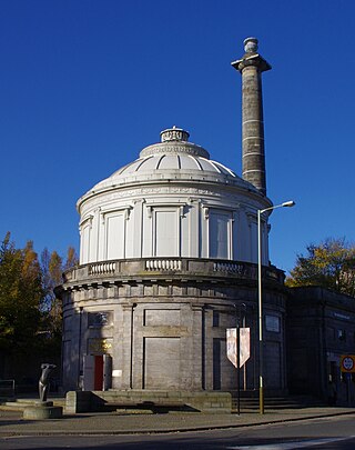
Perth Water Works is an historic building in Perth, Scotland, dating to 1832. Standing at the corner of Tay Street and Marshall Place, the building, a former engine house and water tank, has been the home of The Fergusson Gallery, displaying the work of John Duncan Fergusson, since 1992. The building is Category A listed. Historic Environment Scotland states that it is one of Scotland's most significant industrial buildings, and that its large-scale cast-iron construction may be the first very first in the world.

62–72 Tay Street is an historic row of buildings in Perth, Scotland. Designed by local architect John Young, the building is Category B listed, dating to 1881. Standing on Tay Street, the building was originally the museum home of the Perthshire Society of Natural Science, constructed in memory of Sir Thomas Moncreiffe, 7th Baronet, a past president of the society. The museum housed two exhibits: a local collection and The Type Museum, which illustrated the main types of animals, plants and rocks.
