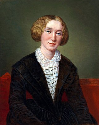
Mary Ann Evans, known by her pen name George Eliot, was an English novelist, poet, journalist, translator, and one of the leading writers of the Victorian era. She wrote seven novels: Adam Bede (1859), The Mill on the Floss (1860), Silas Marner (1861), Romola (1862–1863), Felix Holt, the Radical (1866), Middlemarch (1871–1872) and Daniel Deronda (1876). As with Charles Dickens and Thomas Hardy, she emerged from provincial England; most of her works are set there. Her works are known for their realism, psychological insight, sense of place and detailed depiction of the countryside. Middlemarch was described by the novelist Virginia Woolf as "one of the few English novels written for grown-up people" and by Martin Amis and Julian Barnes as the greatest novel in the English language.

Chelsea is an affluent area in West London, England, due south-west of Charing Cross by approximately 2.5 miles. It lies on the north bank of the River Thames and for postal purposes is part of the south-western postal area.

Cheyne Walk is a historic road in Chelsea, London, England, in the Royal Borough of Kensington and Chelsea. It runs parallel with the River Thames. Before the construction of Chelsea Embankment reduced the width of the Thames here, it fronted the river along its whole length.

Browne Willis was an antiquary, author, numismatist and politician who sat in the House of Commons from 1705 to 1708.
William Cheyne, 2nd Viscount Newhaven was an English Tory politician and peer who sat in the House of Commons of England from 1681 until 1707 when as a viscount in the Peerage of Scotland he was required to sit in the House of Lords.

Old Church Street is a street in London, England in the Royal Borough of Kensington and Chelsea.

Tite Street is a street in Chelsea, London, England, within the Royal Borough of Kensington and Chelsea, just north of the River Thames. It was laid out from 1877 by the Metropolitan Board of Works, giving access to the Chelsea Embankment.

Chelsea Old Church, also known as All Saints, is an Anglican church, on Old Church Street, Chelsea, London SW3, England, near Albert Bridge. It is the church for a parish in the Diocese of London, part of the Church of England. Inside the Grade I listed building, there is seating for 400 people. There is a memorial plaque to the author Henry James (1843–1916) who lived nearby on Cheyne Walk, and was buried in Cambridge, Massachusetts. To the west of the church is a small public garden containing a sculpture by Sir Jacob Epstein.
Lindsey House is a Grade II* listed villa in Cheyne Walk, Chelsea, London. It is owned by the National Trust but tenanted and only open by special arrangement.

The Rosslyn Hill Unitarian Chapel is a place of worship in Hampstead, London. It is a member of the General Assembly of Unitarian and Free Christian Churches, the umbrella organisation for British Unitarians. It is also a Grade II Listed building.

Carlyle Mansions is a block of flats located on Cheyne Walk, in the Chelsea area of London, England. Built in 1886, it was named after Thomas Carlyle, himself a resident of Chelsea for much of his life.

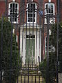
5 Cheyne Walk is a Grade II* listed house on Cheyne Walk, Chelsea, London, built in 1718.

15 Cheyne Walk is a Grade II* listed house on Cheyne Walk, Chelsea, London, built in 1718. It was originally known as Carlton House. It is considered to be a replica of 4 Cheyne Walk.

6 Cheyne Walk is a Grade II* listed house on Cheyne Walk, Chelsea, London, built in 1718.

John Samuel PheneFRGS, FSA, FRIBA was a British architect, who lived in Chelsea, London, for more than 50 years.

Montagu House was a prominent residence situated near to the southwest corner of Greenwich Park, overlooking the common at Blackheath in what is today southeast London. Adjacent to the Ranger's House, it was the royal residence of Caroline of Brunswick before being demolished in 1815.

Oakley Street is in the Royal Borough of Kensington and Chelsea, London. It runs roughly north to south from King's Road to the crossroads with Cheyne Walk and the River Thames, where it continues as the Albert Bridge and Albert Bridge Road. The street was named after Baron Cadogan of Oakley.

Cheyne Row is a residential street in Chelsea, London.

Chelsea Manor Street is a street in Chelsea, London. It runs roughly north to south from Britten Street, crossing King's Road to St Loo Avenue. The southern continuation, Cheyne Gardens ends at Cheyne Walk.