
The 6th of October Governorate was one of the governorates of Egypt. It was located in Middle Egypt, to the west of the Nile valley. It was dissolved on 14 April 2011 and was reincorporated into the Giza Governorate. [1]
The 6th of October Governorate was one of the governorates of Egypt. It was located in Middle Egypt, to the west of the Nile valley. It was dissolved on 14 April 2011 and was reincorporated into the Giza Governorate. [1]
The 6th of October Governorate was split from the Giza Governorate on 17 April 2008. It was created through a presidential decree in order to ease the burden placed on Giza, one of Egypt's most densely populated governorates. [2] The 6th of October City became the capital of the 6th of October Governorate, which was mostly made up of recently established planned communities such as the Sheikh Zayed City. On 14 April 2011, prime minister Essam Sharaf dissolved the 6th of October Governorate and reincorporated its territory into the Giza Governorate. [3]
The governorate's name commemorates the Egyptian military's successful crossing of the Suez Canal on 6 October 1973 during the October War. 6 October is also Egypt's Armed Forces Day.
The area of the 6th of October primarily consists of desert, but contains the left bank of the Nile valley to both the north and south of Giza, and the important oasis town of Bahariya. It is traversed by the northeasterly line of equal latitude and longitude, a line where the northern latitude and eastern longitude are the same.

Cairo is the capital of Egypt and the city-state Cairo Governorate, and is the country's largest city, home to 10 million people. It is also part of the largest urban agglomeration in Africa, the Arab world and the Middle East: The Greater Cairo metropolitan area is the 12th-largest in the world by population with a population of over 22.1 million.
Transport in Egypt is centered in Cairo and largely follows the pattern of settlement along the Nile. The Ministry of Transportation and other government bodies are responsible for transportation in Egypt, whether by sea, river, land or air.

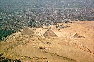
Giza is the third-largest city in Egypt by area after Cairo and Alexandria; and fourth-largest city in Africa by population after Kinshasa, Lagos, and Cairo. It is the capital of Giza Governorate with a total population of 4,872,448 in the 2017 census. It is located on the west bank of the Nile opposite central Cairo, and is a part of the Greater Cairo metropolis. Giza lies less than 30 km (18.64 mi) north of Memphis, which was the capital city of the unified Egyptian state during the reign of pharaoh Narmer, roughly 3100 BC.

Cairo Governorate is one of the 27 governorates of Egypt. It is formed of the city of Cairo, both the national capital of Egypt and the governorate's, in addition to five satellite cities: the New Administrative Capital - set to become the seat of national government, New Cairo, Shourok, Badr, Capital Gardens, and 15th of May. These cities form almost half of the Greater Cairo metropolitan area by population.
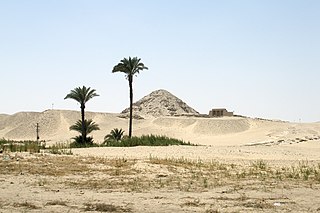
Giza Governorate is one of the governorates of Egypt. It is in the center of the country, situated on the west bank of the Nile River opposite Cairo. Its capital is the city of Giza. It includes a stretch of the left bank of the Nile Valley around Giza, and acquired a large stretch of Egypt's Western Desert, including Bahariya Oasis when the 6th of October Governorate was merged into it on 14 April 2011. The Giza Governorate is also home to the Great Sphinx and the Pyramids of Giza.

Beheira Governorate is a coastal governorate in Egypt. Located in the northern part of the country in the Nile Delta, its capital is Damanhur.
Beni Suef is the capital city of the Beni Suef Governorate in Egypt. Beni Suef is the location of Beni Suef University. An important agricultural trade centre on the west bank of the Nile River, the city is located 110 km south of Cairo.

The Cairo Metro is the rapid transit system in Greater Cairo, Egypt. It was the first of the three full-fledged metro systems in Africa and the first in the Middle East to be constructed. It was opened in 1987 as Line 1 from Helwan to Ramses Square with a length of 29 kilometres (18.0 mi). As of 2013, the metro carried nearly 4 million passengers per day. As of October 2022, the Cairo Metro has 74 stations of which 4 are transfer stations, with a total length of 93.1 kilometres (57.8 mi). The system consists of three operational lines numbered 1 to 3.

Helwan is a suburban district in the Southern Area of Cairo, Egypt. The area of Helwan witnessed prehistoric, ancient Egyptian, Roman and Muslim era activity. More recently it was designated as a city until as late as the 1960s, before it became contiguous with the city of Cairo and was incorporated as a district. For a brief period between April 2008 and April 2011 it was redesignated as a city, and served as the capital of the now defunct Helwan Governorate that was split from Cairo and Giza governorates, before being re-incorporated back into them. The kism of Helwan had a population of 521,239 in the 2017 census.

6th of October is a city in the Giza Governorate of Egypt. It is a satellite city, located adjacent to Giza, and is part of the Greater Cairo region. Per the 2017 national census, it had a population of 450,000 people.
Atfih is a town in Middle Egypt. It was part of the now defunct Helwan Governorate from April 2008 to April 2011, after which it was reincorporated into the Giza Governorate. As of 2001, it has a population of 106,300 inhabitants.

The Greater Cairo Region is a metropolitan area centered around Cairo, Egypt. It comprises the entirety of the Cairo Governorate, the cities of Imbaba and Giza in the Giza Governorate, and the city Shubra El Kheima in Qalyubia Governorate. Its definition can be expanded to include peri-urban areas and a number of new planned towns founded in the desert areas east and west of Cairo. The Greater Cairo Region is also officially defined as an economic region consisting of the Cairo, Giza, and Qalyubia Governorates. Within Greater Cairo lies the largest metropolitan area in Egypt, the largest urban area in Africa, the Middle East, and the Arab world, and the 6th largest metropolitan area in the world.

Egypt is divided, for the purpose of public administration, according to a three-layer hierarchy and some districts are further subdivided, creating an occasional fourth layer. It has a centralized system of local government officially called local administration as it is a branch of the Executive.

Helwan Governorate was one of the governorates of Egypt. It was located in Lower Egypt.
ISO 3166-2:EG is the entry for Egypt in ISO 3166-2, part of the ISO 3166 standard published by the International Organization for Standardization (ISO), which defines codes for the names of the principal subdivisions of all countries coded in ISO 3166-1.
Soldiers of Egypt or Ajnad Misr was a Salafist Islamist militant group that has been operating near Cairo, Egypt. The group was founded by Humam Muhammed in 2013, after he split away from the Ansar Bait al-Maqdis militant group. The group claims that its attacks are "retribution" for the August 2013 Rabaa Massacre; notably, the group targets only security forces. It has warned civilians of the presence of bombs that it has placed.
The Western Desert of Egypt is an area of the Sahara that lies west of the river Nile, up to the Libyan border, and south from the Mediterranean Sea to the border with Sudan. It is named in contrast to the Eastern Desert which extends east from the Nile to the Red Sea. The Western Desert is mostly rocky desert, though an area of sandy desert, known as the Great Sand Sea, lies to the west against the Libyan border. The desert covers an area of 680,650 km2 (262,800 sq mi) which is two-thirds of the land area of the country. Its highest elevation is 1,000 m (3,300 ft) in the Gilf Kebir plateau to the far south-west of the country, on the Egypt-Sudan-Libya border. The Western Desert is barren and uninhabited save for a chain of oases which extend in an arc from Siwa, in the north-west, to Kharga in the south. It has been the scene of conflict in modern times, particularly during the Second World War.
El Saff is a city in the Giza Governorate, Egypt. Its population was estimated at 59,000 people in 2018.
Events in the year 2022 in Egypt.

Al-TabinAl-Tebben and Alos (التبين) is one of the Districts of Cairo Governorate in the Southern Region, it was previously affiliated with Helwan Governorate It remained affiliated with Giza Governorate until 1989.