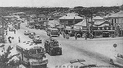
730 (transport)

Last updated

Koza Crossing, Okinawa, circa 1955. Cars drive on the right. Koza Crossroads in 1950s.JPG
Koza Crossing, Okinawa, circa 1955. Cars drive on the right.
Koza Crossing, 2008. Cars drive on the left. Koza Crossroads.jpg
Koza Crossing, 2008. Cars drive on the left.
Kokusai Dori, Naha in the early 1950s with right hand traffic Kokusai Dori in early 1950s.JPG
Kokusai Dori, Naha in the early 1950s with right hand traffic
730 bus of Ryukyu Bus Ryukyu-Bus-3E.jpg
730 bus of Ryūkyū Bus
The 730 Memorial on the 730 Crossing, Ishigaki 730 Crossing Ishigaki Island Japan03s3s4500.jpg
The 730 Memorial on the 730 Crossing, Ishigaki

The 730 (Nana-San-Maru) was the day July 30, 1978, when Okinawa Prefecture of Japan switched back from driving on the right-hand side of the road to the left. [1]

Contents

Overview

Originally, Okinawa drove on the left-hand side of the road, the same as the rest of Japan. However, after the defeat of Japan during World War II, the prefecture went under control of the United States and on June 24, 1945, was made to drive on the right. Even after Okinawa returned to Japanese control in 1972, it still had its traffic driving on the right for six years due to delays in the handover to Japan and delays due to the Expo '75. [2] However, in accordance with Article 9 of the Geneva Convention on Road Traffic that restricts each country to having only one traffic direction, all the traffic in the prefecture was changed back to driving on the left on July 30, 1978. [2] [3] It is one of very few places to have changed from right- to left- traffic in the late twentieth century. [4] The day symbolizes Okinawa's return to Japan.[ citation needed ] Cars sold until this date were generally left-hand drive, unlike those sold on the Japanese mainland. Such cars are referred to as "729 cars", for the day before the switchover.

Changing the direction

All traffic, except emergency vehicles, was banned from 22:00 July 29, 1978. Eight hours after, at 06:00 July 30, traffic resumed, changed on the left-hand side. Traffic signs were changed within these eight hours. [2]

As there were not enough police officers in Okinawa Prefecture to control all the traffic for the day, reinforcements were assembled from other parts of Japan. [2]

Most left-hand side signs and signals were installed and covered before July 30. During the eight-hour transition, the covers were removed and transferred to the old right-hand side signs. The scheme was called the Kudaka Scheme (久高方式, Kudaka Hōshiki), after Hiroshi Kudaka (久高弘, Kudaka Hiroshi), Okinawa Prefectural police officer in charge of 730, who "invented" the scheme.

The prefecture publicized the change beforehand through the 730 Campaign (730キャンペーン), including posters and TV advertisements. The TV advertisement featured Yōkō Gushiken, a famous boxer from the prefecture. [5]

In the prefecture, from the late 1970s until the early 1980s, right-hand drive vehicles were often called 730 cars (730車両 or 730カー), while LHD vehicles were called 729 cars (729車両 or 729カー). Both expressions are now obsolete. Although rare, there are still a few "729 cars" surviving on the road.

The Japanese government spent some $150 million to cover the prefecture's conversion costs, involving 4,200 kilometers (2,610 Miles) of highways. [6] This also included relocating bus stops, moving signs, replacing 1,000 buses and 5,000 taxis, as well as replacing headlights on 300,000 vehicles so that they aimed to the left instead of the right. The United States military spent nearly $500,000 to switch signs on its bases. [2]

Bus

Local bus companies had to change passenger doors on the right-hand side of the vehicle to the left. The bus operators in the prefecture, namely Ryūkyū Bus (the present Ryūkyū Bus Kōtsū), Okinawa Bus, Naha Kōtsū (the present Naha Kōtsū Bus), and Tōyō Bus introduced more than 1000 buses in total, with subsidies from the prefecture and the national government. These particular buses are sometimes called 730 buses (730車両 or 730バス),

Many LHD buses were introduced at the time of Expo '75, held before the 730. As these vehicles were relatively new, some of them were modified to RHD with left-hand side doors. Some others were sold to countries with right hand traffic, such as Mainland China.

Many 730 buses survived until the 2000s. However, most of them retired after 2004. As of 2008, both Okinawa Bus and Tōyō Bus each still preserve one, but neither operates them regularly.

Aftermath

There were many traffic accidents immediately after the 730. When turning right/left on a crossing, drivers often approached to the right-hand side of the road, although they had to approach to the left, resulting in one bus overturning. [7] This led to many collisions on a crossing. Larger accidents included a frontal collision of two buses. [ citation needed ] Left-hand drive vehicles were used in Okinawa prior to the 30 July 1978 traffic switchover sold to right-hand traffic countries like Middle East and Central America.

Memorial

In Ishigaki, there is the 730 Crossing (730交差点) with a 1m tall memorial stone. [8] In Miyakojima, there is the 730 Memorial Tower (730記念塔).

See also

Related Research Articles

<span class="mw-page-title-main">Transport in Samoa</span> Overview of transport in Samoa

Transport in Samoa includes one international airport situated on the north west coast of Upolu island, paved highways reaching most parts of the two main islands, one main port in the capital Apia and two ports servicing mainly inter island ferries for vehicles and passengers between the two main islands, Upolu and Savai'i.

<span class="mw-page-title-main">Left- and right-hand traffic</span> Directionality of traffic flow by jurisdiction

Left-hand traffic (LHT) and right-hand traffic (RHT) are the practices, in bidirectional traffic, of keeping to the left side and to the right side of the road, respectively. They are fundamental to traffic flow, and are sometimes called the rule of the road. The terms right- and left-hand drive refer to the position of the driver and the steering wheel in the vehicle and are, in automobiles, the reverse of the terms right- and left-hand traffic. The rule also includes where on the road a vehicle is to be driven, if there is room for more than one vehicle in the one direction, and the side on which the vehicle in the rear overtakes the one in the front. For example, a driver in an LHT country would typically overtake on the right of the vehicle being overtaken.

<span class="mw-page-title-main">Yomitan</span> Village in Kyushu, Japan

Yomitan is a village located in Nakagami District, Okinawa Prefecture, Japan.

<i>Dagen H</i> 3 Sept 1967 in Sweden, when traffic changed from left- to right-hand

Dagen H (H-day), today usually called "Högertrafikomläggningen", was on 3 September 1967, the day on which Sweden switched from driving on the left-hand side of the road to the right. The "H" stands for "Högertrafik", the Swedish word for right-hand traffic. It was by far the largest logistical event in Sweden's history.

<span class="mw-page-title-main">Uruma</span> City in Kyushu, Japan

Uruma is a city located in Okinawa Prefecture, Japan. The modern city of Uruma was established on April 1, 2005, when the cities of Gushikawa and Ishikawa were merged with the towns of Katsuren and Yonashiro. As of 1 October 2020, the city has an estimated population of 125,303 and a population density of 1,500 people per km2. The total area is 86.00 km2. The city covers part of the east coast of the south of Okinawa Island, the Katsuren Peninsula, and the eight Yokatsu Islands. The Yokatsu Islands include numerous sites important to the Ryukyuan religion, and the city as a whole has numerous historical sites, including: Katsuren Castle, Agena Castle, and Iha Castle and the Iha Shell Mound. It is home to the largest venue for Okinawan bullfighting. The Mid-Sea Road, which crosses the ocean and connects the Yokatsu Islands to the main island of Okinawa, is now a symbol of Uruma.

<span class="mw-page-title-main">Rail transport in Okinawa</span>

Rail transport in Okinawa consists of only the Okinawa Urban Monorail, the only rail line providing rail transportation in Okinawa Prefecture. In the past, Okinawa Island had railroad, trams, and horse-drawn streetcar service. Moreover, Minamidaitōjima and other islands had rail lines to transport sugarcane and other commodities.

National Route 58 is a Japanese national highway connecting the capital cities Kagoshima and Naha of Kagoshima Prefecture and Okinawa Prefecture, respectively. With a total length of 884.4 kilometers (549.5 mi), it is the longest national highway in Japan, though it measures only 245.2 kilometers (152.4 mi) on land. The highway begins at an intersection with National Routes 3 and 10 in Kagoshima. From Kagoshima, it travels southwest along the first island chain that divides the Pacific Ocean from the East China Sea. From the north to the south, it has sections on the islands of Tanegashima, Amami Ōshima, and finally, Okinawa. On Okinawa it ends at an intersection with National Routes 330, 331, and 390 in Naha.

<span class="mw-page-title-main">Nanjō</span> City in Kyushu, Japan

Nanjō is a city located in the southern part of Okinawa Island in Okinawa Prefecture, Japan. Translated literally, the name Nanjō means "southern castle". Many castle ruins, called gusuku in the Okinawan language, can be found throughout the city. The modern city of Nanjō was established on January 1, 2006, from the merger of the town of Sashiki, and the villages of Chinen, Ōzato and Tamagusuku. Nanjō has an area of 49.94 km² and, on the date of its inception, a population of 46,690, and a density of 934.92 per km².

<span class="mw-page-title-main">Naha</span> Capital city of Okinawa Prefecture, Japan

Naha is the capital city of Okinawa Prefecture, the southernmost prefecture of Japan. As of 1 June 2019, the city has an estimated population of 317,405 and a population density of 7,939 people per km2. The total area is 39.98 km2 (15.44 sq mi).

<span class="mw-page-title-main">Okinawa (city)</span> City in Kyushu, Japan

Okinawa City is the second-largest city in Okinawa Prefecture, Japan, following Naha, the capital city. It is located in the central part of the island of Okinawa, about 20 kilometres (12 mi) north of Naha. As of 1 October 2020, the city has an estimated population of 142,752 and a population density of 2,913.31 people per km2. The total area is 49.00 km2.

<span class="mw-page-title-main">Ryukyu independence movement</span> Political movement in Japan

The Ryukyu independence movement or the Republic of the Ryukyus is a political movement advocating for the independence of the Ryukyu Islands from Japan.

<span class="mw-page-title-main">Okinawan scripts</span>

Okinawan, spoken in Okinawa Island, was once the official language of the Ryukyu Kingdom. At the time, documents were written in kanji and hiragana, derived from Japan.

<span class="mw-page-title-main">Keio 3000 series</span> Japanese train type

The Keio 3000 series was a DC electric multiple unit (EMU) train type operated by Keio Corporation on the Keio Inokashira Line in Japan from 1962 until 2011.

<span class="mw-page-title-main">Japan National Route 390</span> Road in Okinawa prefecture, Japan

National Route 390 is both the southernmost and westernmost of the national highways of Japan. It connects Ishigaki, Okinawa on Ishigaki Island, to Miyako-jima, and Naha, Okinawa on Okinawa Island in Japan. Spanning the three islands by ferry, the highway has a total length of 58.2 kilometers (36.2 mi) on land and 552.2 kilometers (343.1 mi) when maritime distance is added.

<span class="mw-page-title-main">Koza riot</span> 1970 protest against US military presence in Okinawa, Japan

The Koza riot was a violent and spontaneous protest against the US military presence in Okinawa, which occurred on the night of December 20, 1970, into the morning of the following day. Roughly 5,000 Okinawans clashed with roughly 700 American MPs in an event which has been regarded as symbolic of Okinawan anger against 25 years of US military administration. In the riot, approximately 60 Americans and 27 Okinawans were injured, 80 cars were burned, and several buildings on Kadena Air Base were destroyed or heavily damaged.

<span class="mw-page-title-main">Tsuken Island</span>

Tsuken Island is an island in the Pacific Ocean in Uruma, Okinawa Prefecture, Japan. The island is southernmost of the Yokatsu Islands, and is located 3.8 kilometres (2.4 mi) south south-east of the Katsuren Peninsula off Okinawa Island at the entrance of Nakagusuku Bay. Tsuken covers 1.88 square kilometres (0.73 sq mi) and has a population of 487 residents.

OKICA, short for "Okinawa IC Card", is a contactless smart card used for public transport in Okinawa.

<span class="mw-page-title-main">Names of Okinawa</span> Archipelago of Japanese islands

Okinawa (沖縄) is a name with multiple referents. The endonym refers to Okinawa Island in southwestern Japan. Today it can cover some surrounding islands and, more importantly, can refer to Okinawa Prefecture, a much larger administrative division of Japan, although the people from the Miyako and Yaeyama Islands still feel a strong sense of otherness to Okinawa.

Yasuo Higa was an Okinawan photographer, ethnologist and anthropologist. He served ten years as a police officer near a US military base before becoming a photographer, with much of his early work centered on life in postwar Okinawa. Higa is most known for his research on ancient rituals and shamanesses from the Ryukyu Islands, mainland Japan, and Asia, conducted over the span of nearly 40 years. Through his photographs and extensive notes, Higa has preserved critical documentation on maternal rituals that have been effectively rendered extinct in areas such as Kudaka and Miyakojima.

Ryukyu New Year is a traditional New Year in the Ryukyu Islands. Japan fully uses the Gregorian calendar after the Meiji Restoration, but the Ryukyu Islands still celebrate the New Year on the first day of the first month of the lunar calendar.

References

  1. White Papers of Japan 1978-79. Japan Institute of International Affairs. 1980. p. 157.
  2. 1 2 3 4 5 Malcolm, Andrew H. "U-Turn for Okinawa: From Right-Hand Driving to Left; Extra Policemen Assigned", The New York Times , July 5, 1978. Accessed December 14, 2008.
  3. "UNTC". United Nations Treaty Collection. Retrieved May 15, 2024.
  4. The Guinness Book of Answers, Norris McWhirter, Guinness Books, 1985, page 118
  5. Frost, Dennis J. (2010). Seeing Stars: Sports Celebrity, Identity, and Body Culture in Modern Japan. Harvard University Press. p. 195. ISBN   9780674056107.
  6. Gordon Warner (1995). The Okinawan reversion story: war, peace, occupation, reversion, 1945-1972. Executive Link. p. 201.
  7. "New Law Blamed For Accident". The Spokesman-Review . July 31, 1978.
  8. Miyara and local children clean and repaint 730 monument, Ryukyu Shimpo , August 4, 2012