
The geography of Antarctica is dominated by its south polar location and, thus, by ice. The Antarctic continent, located in the Earth's southern hemisphere, is centered asymmetrically around the South Pole and largely south of the Antarctic Circle. It is washed by the Southern Ocean or, depending on definition, the southern Pacific, Atlantic, and Indian Oceans. It has an area of more than 14 million km².
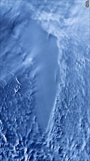
Lake Vostok is the largest of Antarctica's almost 400 known subglacial lakes. Lake Vostok is located at the southern Pole of Cold, beneath Russia's Vostok Station under the surface of the central East Antarctic Ice Sheet, which is at 3,488 m (11,444 ft) above mean sea level. The surface of this fresh water lake is approximately 4,000 m (13,100 ft) under the surface of the ice, which places it at approximately 500 m (1,600 ft) below sea level.

The climate of Antarctica is the coldest on Earth. The lowest air temperature record on Antarctica was set on 21 July 1983, when −89.2 °C (−128.6 °F) was observed at Vostok Station. Satellite measurements have identified even lower ground temperatures, with −93.2 °C (−135.8 °F) having been observed at the cloud-free East Antarctic Plateau on 10 August 2010.
The lowest natural temperature ever directly recorded at ground level on Earth is −89.2 °C at the Soviet Vostok Station in Antarctica on 21 July, 1983 by ground measurements.
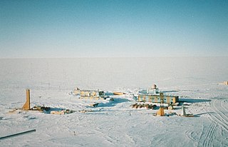
Vostok Station is a Russian research station in inland Princess Elizabeth Land, Antarctica. Founded by the Soviet Union in 1957, the station lies at the southern Pole of Cold, with the lowest reliably measured natural temperature on Earth of −89.2 °C. Research includes ice core drilling and magnetometry. Vostok was named after Vostok, the lead ship of the First Russian Antarctic Expedition captained by Fabian von Bellingshausen.
A rift valley is a linear shaped lowland between several highlands or mountain ranges created by the action of a geologic rift or fault. A rift valley is formed on a divergent plate boundary, a crustal extension or spreading apart of the surface, which is subsequently further deepened by the forces of erosion. When the tensional forces are strong enough to cause the plate to split apart, a center block drops between the two blocks at its flanks, forming a graben. The drop of the center creates the nearly parallel steeply dipping walls of a rift valley when it is new. That feature is the beginning of the rift valley, but as the process continues, the valley widens, until it becomes a large basin that fills with sediment from the rift walls and the surrounding area. One of the best known examples of this process is the East African Rift. On Earth, rifts can occur at all elevations, from the sea floor to plateaus and mountain ranges in continental crust or in oceanic crust. They are often associated with a number of adjoining subsidiary or co-extensive valleys, which are typically considered part of the principal rift valley geologically.
This is a list of extreme points in Antarctica.

Sovetskaya was a Soviet research station in Kaiser Wilhelm II Land in Antarctica that was established on 16 February 1958 and closed on 3 January 1959.
Princess Elizabeth Land is the sector of Antarctica between longitude 73° east and Cape Penck. The sector is claimed by Australia as part of the Australian Antarctic Territory, although this claim is not widely recognized. Princess Elizabeth Land is located between 64°56'S and 90°00'S and between 73°35' E and 87°43'E. It is divided into two sectors:

Sovetskaya Lake is a liquid subglacial lake found buried under the Antarctic ice sheet, 2 kilometres (6,600 ft) below Sovetskaya Research Station. It covers about 1,600 square kilometres (620 sq mi).

The Soviet Antarctic Expedition was part of the Arctic and Antarctic Research Institute of the Soviet Committee on Antarctic Research of the Academy of Sciences of the USSR.
The Third Soviet Antarctic Expedition (1957–59) was led by Yevgeny Tolstikov on the continent and included Czech future astronomer Antonín Mrkos; the marine expedition on the Ob was led by I V Maksimov.
Lake Ellsworth is a natural freshwater liquid subglacial lake located in West Antarctica under approximately 3.4 km (2.1 mi) of ice. It is approximately 10 km long and is estimated to be 150 m (490 ft) in depth. The lake is named after the American explorer Lincoln Ellsworth. The surface of the lake itself is located over 4,593 feet (1,400 m) below sea level.
The Gamburtsev Mountain Range is a subglacial mountain range located in East Antarctica, just underneath the lofty Dome A, near the Southern Pole of Inaccessibility. The range was discovered by the 3rd Soviet Antarctic Expedition in 1958 and is named for Soviet geophysicist Grigoriy A. Gamburtsev. It is approximately 1,200 kilometres (750 mi) long, and the mountains are believed to be about 2,700 metres (8,900 ft) high, although they are completely covered by over 600 metres (2,000 ft) of ice and snow. The Gamburtsev Mountain Range is currently believed to be about the same size as the European Alps, and, as of 2008, it is unknown how the mountains were formed, though the current speculated age of the range is over 34 million years and possibly 500 million years. Current models suggest that the East Antarctic ice sheet was formed from the glaciers that began sliding down the Gamburtsev range at the end of the Eocene. Vostok Subglacial Highlands form an east extension of Gamburtsev Subglacial Mountains.
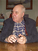
Andrey Petrovich Kapitsa was a Russian geographer and Antarctic explorer, discoverer of Lake Vostok, the largest subglacial lake in Antarctica. He was a member of the Kapitsa family, a scientific dynasty in Russia.
There are hundreds of antarctic lakes, in Antarctica. In 2018 researchers at the Alfred Wegener Institute's Helmholtz Centre for Polar and Marine Research published a study they claimed cast doubt on earlier estimate that there were almost 400 subglacial antarctic lakes. Antarctica also has some relatively small regions that are clear of ice and snow, and there are some surface lakes in these regions. They called for on the ground seismic studies, or drilling, to determine a more reliable number.

Vostok was a 28-gun sloop-of-war of the Imperial Russian Navy, the lead ship of the First Russian Antarctic Expedition in 1819—1821, during which Fabian Gottlieb von Bellingshausen and Mikhail Lazarev circumnavigated the globe, discovered the continent of Antarctica and twice circumnavigated it, and discovered a number of islands and archipelagos in the Southern Ocean and the Pacific.
Martin J. Siegert is a British glaciologist, a professor at Imperial College London, and co-director of the Grantham Institute - Climate Change and Environment.


