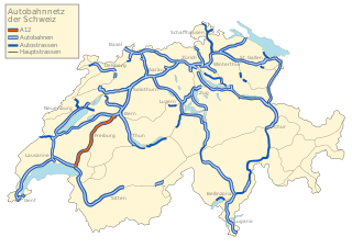
The A12 runs from the A9 in Vevey along the Freiburger Alps via Fribourg to the A1 in Bern and thus represents an important link to Western Switzerland. The A12 acts as the main route of the Canton of Freiburg and crosses the Canton area in the diagonal of Chatel-Saint-Denis (in the southwest) to the Flamatt in the northeast. Since 1981, the entire highway has been open to traffic. A scenic location on the Lac de la Gruyère is the resting place de Gruyère, with its adjacent hotel.
Route
The A12 travels from the junction of the A9 La Veyre on a plateau (500 m above sea level) over Vevey. During the first 5.5 kilometres (3.4mi), the highway rises along the eastern flank of the Veveyse up to 820 metres (2,690ft) above sea level and forms a sharp S-curve. This highway section, with an average gradient of 5.8% (and maximum gradients over 6%), is one of the steepest stretches of motorway in the Swiss national road network. After the ascent portion, the canyon of Veveyse de Fégire is crossed by a bridge. Once reaching the plateau of Haute Veveyse, at the foot of the Alps, the road has only small differences in height. The culminating point is located, at an altitude of 866 metres (2,841ft) above sea level, at Weiler Prayoud northeast of Chatel-Saint-Denis. Here are the main European watershed between the Rhone with the catchment area of the Veveyse, and passes the Rhine (with the catchment areas of Broye and Sarine).
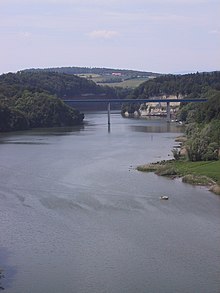
A12 bridge at Schiffenensee
At a length of 15 kilometres (9.3mi), the A12 now runs at an altitude of about 800 metres (2,600ft) above sea level, before it reaches the Gruyère region and the basin of Bulle. It then runs between the reservoir Lac de la Gruyère and the heights of Le Gibloux to the north. At Gumefens and Avry-devant-Pont there are two Tagbau-tunnels. North of the latter is the most important building of the A12, the approximately 2-km long Viaduc du Lac de la Gruyère, constructed during the years 1974–1979 in a sweeping curve to the western valley side, spanning two short arms of the Lac de la Gruyère.
Afterwards, the highway enters the Molasse plateau of Freiburg Plateau, tackling in several stages a height difference of just over 100 metres (330ft). After the bridge over the Glâne, the agglomeration of Freiburg in the west and northwest is bypassed through hilly terrain, known before (with another bridge over the Schiffenensee and Pont de la Madeleine, in line to the little hermitage in the sandstone cliffs near the highway bridge), and thus the Sarine gulch crosses the German/French language border.
As a result, the corridor runs through the little reliefs plateau at Düdingen and Wünnewil. With a bridge at Flamatt, which has a gradient of 4%, the road leaves the plateau and reaches the valley of the Sense (river). Thereafter, the A12 runs through the relatively densely populated and industrial and commercial buildings lined Wangental valley, to the western border of the city of Bern. Following is the Southern Bypass of the district Bümpliz, with an almost 1-kilometre-long (0.62mi) bridge crossing the plateau, before the highway ends at the junction Weyermannshaus into the A1.
Engineering structures
Highway Bridge Flamatt
The A12 has, due to the hilly, pre-alpine topography, some different engineering structures, especially bridges. The most significant of which are (in sequence from Vevey to Bern):
Viaduct Fégire: 512m (1,680ft) long, 90m (300ft) high
Tunnel de Gumefens: 340m (1,120ft) long, Tagbautunnel
Tunnel d'Avry: 170m (560ft) long, Tagbautunnel
Viaduc du Lac de la Gruyère: 2.044km (1.270mi) long, 33 piers, piers with a height of 2 to 85 metres (6.6 to 278.9ft)
Viaduc de la Glâne: approximately 200m (660ft) long, 40m (130ft) high
Pont de la Madeleine (bridge over the Schiffenensee): 320m (1,050ft) long, a medium storage level of the lake 41m (135ft) above the water surface
Bridge Flamatt: 648m (2,126ft) long, 4% incline, leading through residential and commercial neighborhoods of Flamatt
Tagbautunnel Thörishaus: 110m (360ft) long
Viaduct Weyermannshaus: 0.912 kilometres (0.567mi) long, 10 to 15 metres (33 to 49ft) high
Historical aspects
The leadership of a motorway, through the Canton of Freiburg, had already been studied in the 1950s decade. Concrete plans on the lines of the first sections have been around since the beginning of the 1960s. The first walked the line between Corpataux Matran and the end of 1963, for consultation, a year later it was followed by the northeastern continuation of the highway to Düdingen. In 1966 and 1967, the sections were sanctioned by the then Department of the Environment, Transport, Energy and Communications of the Swiss Federal and soon started to build.
On 31 July 1971, with the section of Düdingen Corpataux, the first leg of the A12 was in operation. The city of Fribourg was thus a bypass for transit traffic. It was first created by Matran Corpataux as only one lane, the second lane followed about seven years later. The last section of the A12, between Vaulruz and Vevey, was opened at the end of 1981.
Opening of the A12 Autobahn sections
Section
Date
A1 - Thörishaus
7 Dec 1977
Thörishaus - Flamatt
6 Dec 1976
Flamatt - Düdingen
27 Sep 1973
Düdingen - Matran
31 Jul 1971
Matran - Corpataux: 1st Richtungsfahrbahn
31 Jul 1971
Matran - Corpataux: 2nd Richtungsfahrbahn
14 Jul 1978
Corpataux - Avry-devant-Pont
31 Oct 1979
Avry-devant-Pont - Vuippens
23 Nov 1981
Vuippens - Bulle
8 Nov 1978
Bulle - Vaulruz
29 Jul 1977
Vaulruz - A9
23 Nov 1981
The thruway A12 existed from end to end in 1981, as a motorway link between the German-speaking Switzerland and those in western Switzerland. As a result, developed the line from Bern via the A12 and the A9 for Lausanne on the A1 for approximately 20 years to the main transit route between Zürich and Geneva. However, the A12, during the winter, was always vulnerable to ice and snow-covered roadways because of the steep gradients and long sections at elevations above 700 metres (2,300ft).
As has been made consistently in 2001, the A1 is also in operation, shifted back some of the traffic on the originally planned as a transit route highway. This is very well documented by the counting stations of Wünnewil and bull (overland routes), which in 2000 were measured in the average daily volume of 29,000 vehicles, 2002 just over 22,000 vehicles (about 20% less than two years before). The highest traffic densities on the A12 were recorded 2004, in the Fribourg area, with an average daily traffic of 29,000 vehicles.
The full opening of the A12 in particular gave the regions of Fribourg and Bones and the structurally Haute Veveyse important economic stimulus and led to the easy accessibility to the tourist region of Gruyère, both from the Lake Geneva region as well as from Berne.
Major engineering works
The following are major construction projects underway along A12:
Switzerland has a dense network of roads and railways. The Swiss public transport network has a total length of 24,500 kilometres and has more than 2600 stations and stops.
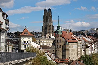
Fribourg is the capital of the Swiss canton of Fribourg and district of La Sarine. Located on both sides of the river Saane/Sarine, on the Swiss Plateau, it is a major economic, administrative and educational centre on the cultural border between German-speaking and French-speaking Switzerland. Its Old City, one of the best-maintained in Switzerland, sits on a small rocky hill above the valley of the Sarine. In 2018, it had a population of 38,365.
Vaud, more formally the canton of Vaud, is one of the 26 cantons forming the Swiss Confederation. It is composed of ten districts, and its capital city is Lausanne. Its coat of arms bears the motto "Liberté et patrie" on a white-green bicolour.
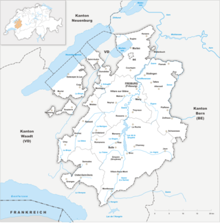
The canton of Fribourg, also canton of Freiburg is located in western Switzerland. The canton is bilingual, with French spoken by more than two thirds of the citizens and German by a little more than a quarter. Both are official languages in the canton. The canton takes its name from its capital city of Fribourg.
Lake Neuchâtel is a lake primarily in Romandy, the French-speaking part of Switzerland. The lake lies mainly in the canton of Neuchâtel, but is also shared by the cantons of Vaud, Fribourg, and Bern. It comprises one of the lakes in the Three Lakes Region, along with lakes Biel/Bienne and Morat/Murten.
There are 126 municipalities in the canton of Fribourg, Switzerland.
The A13 is a motorway, at times an Autostrasse (expressway), which runs from St. Margrethen in northeastern Switzerland through to Ascona in southern Switzerland, crossing the main chain of the Alps in the Grisons area. It is the southern half of European route E43.
Switzerland has a two-class highway system: motorways with separated roads for oncoming traffic and a standard maximal speed limit of 120 kilometres per hour (75 mph), and expressways often with oncoming traffic and a standard maximal speed limit of 100 kilometres per hour (62 mph).
Lake of Gruyère is an artificial lake in the La Gruyère region of the Canton of Fribourg, Switzerland.
The Transports Publics Fribourgeois (TPF) is a renaming of the former Chemins de fer Fribourgeois Gruyère-Fribourg-Morat when the municipal Transport en commun de Fribourg (TF) was absorbed in 2000.
The Chemins de fer fribourgeois Gruyère–Fribourg–Morat (GFM) was a railway company in Switzerland. It was established with the merger in 1942 of two standard gauge and one 1,000 mm gauge railways running mainly within the Swiss canton of Fribourg. It was officially called the Compagnie des Chemins de fer fribourgeois. The company also operated numerous regional buses in the same area. After a merger with Fribourg city transport, the company was renamed Transports publics fribourgeois/Freiburgische Verkehrsbetriebe (TPF).
Schmitten is a municipality in the district of Sense in the canton of Fribourg in Switzerland. It is one of the municipalities with a large majority of German speakers in the mostly French speaking Canton of Fribourg.
The A16, a motorway in north-central Switzerland, is a divided freeway connecting the border to France to the A5 motorway, 84 kilometres (52 mi) to the south on the Swiss plateau.
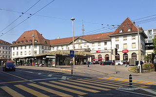
Fribourg/Freiburg railway station serves the municipality of Fribourg, capital of the canton of Fribourg, Switzerland. Opened in 1862, it is owned and operated by SBB-CFF-FFS.
Ignace Nazaire Oswald Pilloud was a Swiss painter and illustrator.
Les Paccots is a village and a small ski resort of the Swiss Prealps, located in the canton of Fribourg.
The Niremont is a mountain of the Swiss Prealps, in the canton of Fribourg. Due to its rounded shape, it has 2 sub-summits : The Gros Niremont and the Petit Niremont.
Corbetta is a mountain of the Swiss Prealps, in the canton of Fribourg.
The Grandfey-Viaduct is on the railway line from Bern to Fribourg and is one of the largest bridges in Switzerland.
RER Fribourg or RER Fribourg | Freiburg is an S-Bahn network in the canton of Fribourg in Switzerland. The network has two hubs, Bulle and Fribourg, and began operating in 2011.
References
"Die Schweitzer Autobahnen", Autobahnen.ch, 2009, web: Autobahnen.ch (with sub-webpage for A9).
This page is based on this Wikipedia article Text is available under the CC BY-SA 4.0 license; additional terms may apply. Images, videos and audio are available under their respective licenses.