
Valais, more formally, the Canton of Valais, is one of the 26 cantons forming the Swiss Confederation. It is composed of thirteen districts and its capital and largest city is Sion.

The Simplon Pass is a high mountain pass between the Pennine Alps and the Lepontine Alps in Switzerland. It connects Brig in the canton of Valais with Domodossola in Piedmont (Italy). The pass itself and the villages on each side of it, such as Gondo, are in Switzerland. The Simplon Tunnel was built beneath the vicinity of the pass in the early 20th century to carry rail traffic between the two countries.

The A3 is a motorway in northeast Switzerland, running diagonally from France toward the southeast border, and passing by Zürich on the way. The total length of the A3 motorway spans roughly 180 kilometres (110 mi), but parts of the road share sections of the A1 and A2 motorways.

The A13 is a motorway, at times an Autostrasse (expressway), which runs from St. Margrethen in northeastern Switzerland through to Ascona in southern Switzerland, crossing the main chain of the Alps in the Grisons area. It is the southern half of European route E43.
The Autobahn is the federal controlled-access highway system in Germany. The official term is Bundesautobahn, which translates as 'federal motorway'. The literal meaning of the word Bundesautobahn is 'Federal Auto(mobile) Track'.

Bundesautobahn 7 is the longest German Autobahn and the longest national motorway in Europe at 963 km. It bisects the country almost evenly between east and west. In the north, it starts at the border with Denmark as an extension of the Danish part of E45. In the south, the autobahn ends at the Austrian border. This final gap was closed in September 2009.

The Simplon Tunnel is a railway tunnel on the Simplon railway that connects Brig, Switzerland and Domodossola, Italy, through the Alps, providing a shortcut under the Simplon Pass route. It is straight except for short curves at either end. It consists of two single-track tunnels built nearly 15 years apart. The first to be opened is 19,803 m (64,970 ft) long; the second is 19,824 m (65,039 ft) long, making it the longest railway tunnel in the world for most of the twentieth century, from 1906 until 1982, when the Daishimizu Tunnel opened.
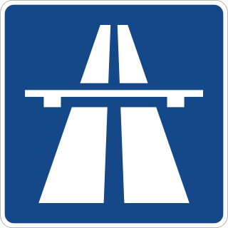
Switzerland has a two-class highway system: motorways with separated roads for oncoming traffic and a standard maximal speed limit of 120 kilometres per hour (75 mph), and expressways often with oncoming traffic and a standard maximal speed limit of 100 kilometres per hour (62 mph).
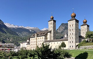
Brig, officially Brig-Glis, is a historic town and municipality in the district of Brig in the canton of Valais in Switzerland. The current municipality was formed in 1972 through the merger of Brig (city), Brigerbad and Glis.

The A16, a motorway in north-central Switzerland, is a divided freeway connecting the border to France to the A5 motorway, 84 kilometres (52 mi) to the south on the Swiss plateau.

The A14 motorway, an Autobahn in central Switzerland, is a divided highway connecting the A2 with the A4, within the Canton of Lucerne.
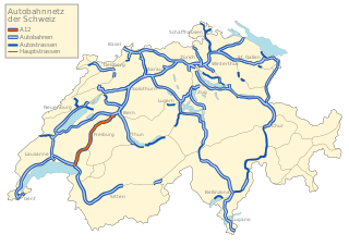
The A12 motorway, an Autobahn in western Switzerland, is a divided highway connecting the A9 to the A1.

The Lötschberg line is a railway in Switzerland, connecting Spiez in the canton of Bern with Brig in the canton of Valais. It crosses the Bernese Alps, from the Bernese Oberland to Upper Valais, through the Lötschberg Tunnel in the middle of the line. Together with the Simplon Tunnel south of Brig, it constitutes one of the major railways through the Alps and an important north-south axis in Europe. The Lötschberg axis is backed by the lower and longer Lötschberg Base Tunnel, part of the New Railway Links through the Alps project.

The A8 motorway, an Autobahn in central Switzerland, is a divided highway connecting the Bernese Oberland and the Innerschweiz. It is part of the National Road N8. For the Canton of Obwalden, it is the lifeline that has allowed the settling of industrial firms in this historically predominantly agricultural region. Via the A8, speedy connections to the major economic centers in the Mittelland and the north–south transit axis A2 are now possible. For tourists, A8 opens up in the opposite direction: the large ski resorts in the Bernese Oberland and the tourism regions around the Brünig Pass and Interlaken.
Steg-Hohtenn is a municipality in the district of Raron in the canton of Valais in Switzerland. The municipality comprises the villages of Steg and Hohtenn.

Speed limits in Germany are set by the federal government. All limits are multiples of 10 km/h. There are two default speed limits: 50 km/h (31 mph) inside built-up areas and 100 km/h (62 mph) outside built-up areas. While parts of the autobahns and many other freeway-style highways have posted limits up to 130 km/h (81 mph) based on accident experience, congestion and other factors, many rural sections have no general speed limit for some classes of vehicles. The Road Traffic Regulations (StVO) section on speed begins with the requirement which may be rendered in English:
Any person driving a vehicle may only drive so fast that the car is under control. Speeds must be adapted to the road, traffic, visibility and weather conditions as well as the personal skills and characteristics of the vehicle and load.

The Simplon Valley or Divedro Valley is a valley of the Alps, situated between the Pennine and the Lepontine ranges. The valley is drained by the Diveria or Chrummbach, a tributary of the Toce at Crevoladossola. The Simplon Valley is the only valley of Valais located south of the main chain of the Alps.

The Simplon Railway is a line that links Lausanne in Switzerland and Domodossola in Italy, via Brig. The 20 km (12 mi)-long Simplon Tunnel is a major part of it. The line between Lausanne and Vallorbe is sometimes considered to form part of the line, making it 233 km (145 mi) long.

The Compagnie de la Ligne d’Italie, or Ligne d’Italie for short, was a former Swiss railway company that established in 1859. In 1874, the Ligne d'Italie became part of the Compagnie du Simplon. The Compagnie du Simplon, Ligne du Simplon or Simplon for short, merged into the Western Swiss Railways in 1881.

Sierre/Siders railway station is a railway station in the municipality of Sierre, in the Swiss canton of Valais. It is an intermediate stop on the Simplon line and is served by local and long-distance trains.

