The A9 (CREL / Lisbon Regional Outer Circular) is a Portuguese motorway which, as the name indicates, forms a partial outer circular route beyond the north and western parts of the Lisbon conurbation. It thereby links the Estoril coastal area with principal highways towards the north of the country.
Lisbon is the capital and the largest city of Portugal, with an estimated population of 505,526 within its administrative limits in an area of 100.05 km2. Its urban area extends beyond the city's administrative limits with a population of around 2.8 million people, being the 11th-most populous urban area in the European Union. About 3 million people live in the Lisbon Metropolitan Area. It is mainland Europe's westernmost capital city and the only one along the Atlantic coast. Lisbon lies in the western Iberian Peninsula on the Atlantic Ocean and the River Tagus. The westernmost areas of its metro area form the westernmost point of Continental Europe, which is known as Cabo da Roca, located in the Sintra Mountains.
Estoril is a town in the Municipality of Cascais, Portugal, on the Portuguese Riviera. Estoril is famed as a luxury entertainment destination on the Portuguese Riviera, as home of the Casino Estoril.
The road begins near to the National Stadium of Jamor and sets off in an approximately east-north-easterly direction, intersecting along the way with major regional roads ( IC19, A16, IC22 ) as well as two national motorways, the A8 and the A10. It passes Queluz in the edge of Sintra, then through the Amadora, Odivelas and Louresmunicipalities before ending after 35 kilometres (22mi) at an intersection with the country's principal northbound highway, the A1.
The National Stadium Sports Complex, also known as Jamor Sports Complex, is a national football ground used by the Portugal national team and, as of 2018, by Belenenses SAD. It is located in the civil parish of Algés, Linda-a-Velha e Cruz Quebrada-Dafundo, in the municipality of Oeiras, in the western part of Lisbon District.
The A8, called in Portuguese: Auto-estrada do Oeste, is a motorway (freeway) in Portugal, connecting Lisbon and Leiria via Caldas da Rainha. The A17 connects to it in Marinha Grande and runs into Aveiro. A8 is operated by Auto-Estradas do Atlântico. It has a total length of 132 km.
The A10 is a short Portuguese motorway to the north and north-east of Lisbon.
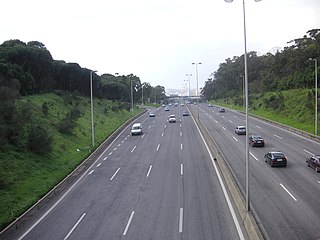
Despite running for its entire length within 20 kilometres (12mi) of central Lisbon, much of the route of the A9 is semi-urban or rural, incorporating mountainous regions that necessitated the inclusion of 15 viaducts and two substantial tunnels in its construction. It therefore is a very hilly road, with several tight turns along its way.
History
The most westerly four kilometres (2.5mi) of the A9 were opened in 1994, with the remaining 31 kilometres (19mi) opening in September 1995. There was an idea to extend the westerly portion of the ring highway southwards across an additional bridge, but extending the A9 in this way appears not to have evolved beyond the status of an ambitious line on the map, and a second major highway bridge crossing the Tagus to the east of Lisbon has been constructed in the interim. The A9 is operated by Portugal's principal highway operator Brisa. When opened, it was toll motorway, but tolls were abolished in December 1995 by the government of António Guterres. In January 2003 the government of José Manuel Durão Barroso re-introduced tolls, a decision which was controversial. As of 2012[update] the charge for a passenger car to travel the full 35 kilometres (22mi) from one end of the road to the other is €2.95.
The Vasco da Gama Bridge is a cable-stayed bridge flanked by viaducts and rangeviews that spans the Tagus River in Parque das Nações in Lisbon, the capital of Portugal.
Brisa – Auto-estradas de Portugal, S.A. is a Portugal-based international transportation company. The group's largest business area is highway management, in which it is the largest concessionaire in its home country. Founded in 1972 by Jorge de Brito, Brisa also has operations in countries including the United States and the Netherlands. Since 2000 Brisa's largest shareholder has been the investment company Grupo José de Mello, which owns over 30% of its stock through subsidiaries. The Spanish infrastructure company Abertis holds around 15% of the firm. The company is listed on the Lisbon Stock Exchange and is a constituent of the benchmark PSI-20 and Euronext 100 indices.
António Manuel de Oliveira Guterres is a Portuguese politician and diplomat who is serving as the ninth Secretary-General of the United Nations. Previously, he was the United Nations High Commissioner for Refugees between 2005 and 2015.
January 2010
In the middle of the afternoon on 24 January 2010, near Belas, next to the junction with the newly opened the A16 a violent landslip deposited a large quantity of rocks and mud on the road. There is no record of any resulting road accident, but for more than a month the road was unusable and traffic had to be diverted, leading to serious congestion. Repairs were completed and the road fully repaired in time for it to be reopened on 25 February 2010.
This page is based on this Wikipedia article Text is available under the CC BY-SA 4.0 license; additional terms may apply. Images, videos and audio are available under their respective licenses.
Related Research Articles
A ring road is a road or a series of connected roads encircling a town, city, or country. The most common purpose of a ring road is to assist in reducing traffic volumes in the urban centre, such as by offering an alternate route around the city for drivers who do not need to stop in the city core.
The Hume Highway, inclusive of the sections now known as the Hume Freeway and Hume Motorway, is one of Australia's major inter-city national highways, running for 840 kilometres (520 mi) between Melbourne in the southwest and Sydney in the northeast. Upgrading of the route from Sydney's outskirts to Melbourne's outskirts to dual carriageway was completed on 7 August 2013.
Westlink M7 - formerly Western Sydney Orbital - is one of Sydney, Australia's urban motorways and a part of the Sydney Orbital Network. It is a tolled motorway that is operated by Transurban and connects three motorways: M5 South Western Motorway at Prestons, M4 Western Motorway at Eastern Creek and M2 Hills Motorway at Baulkham Hills. It opened on 16 December 2005, eight months ahead of schedule.
A limited-access road, known by various terms worldwide, including limited-access highway, dual-carriageway, expressway, and partial controlled access highway, is a highway or arterial road for high-speed traffic which has many or most characteristics of a controlled-access highway, including limited or no access to adjacent property, some degree of separation of opposing traffic flow, use of grade separated interchanges to some extent, prohibition of some modes of transport such as bicycles or horses, and very few or no intersecting cross-streets. The degree of isolation from local traffic allowed varies between countries and regions. The precise definition of these terms varies by jurisdiction.
King's Highway 48, also known as Highway 48, is a provincially maintained highway in southern Ontario that extends from Major Mackenzie Drive in Markham, through Whitchurch-Stouffville and East Gwillimbury, to Highway 12 south-east of Beaverton. The route is generally rural and straight, passing near several communities within the Regional Municipality of York. The route is 65.2 kilometres (40.5 mi) long. Most part of the road has a speed limit of 80 km/h (50 mph), except within town limits, where the speed limit is reduced to 60 km/h (37 mph) or 50 km/h (31 mph).
The Sunshine Motorway is a thirty-three kilometre Australian motorway on the Sunshine Coast region of Queensland, just north of Brisbane. It was initially a tolled motorway before these were removed in 1996 after excessive complaint regarding any such need of a toll. It is part of State Route 70, which extends north a further 12.3 kilometres to Noosaville. For completeness, and to aid in understanding of the usage of this road, the extension is included in this article.
A controlled-access highway is a type of highway which has been designed for high-speed vehicular traffic, with all traffic flow ingress- and egress-regulated. Common English terms are freeway, motorway and expressway. Other similar terms include Interstate and parkway. Some of these may be limited-access highways, although this term can also refer to a class of highway with somewhat less isolation from other traffic.
The Gateway Motorway is a major tolled motorway in Brisbane, Queensland, Australia which includes the Sir Leo Hielscher Bridges. The motorway is operated by toll road operator Transurban.
State Highway 1 is the longest and most significant road in the New Zealand road network, running the length of both main islands. It appears on road maps as SH 1 and on road signs as a white number 1 on a red shield, but it has the official designations SH 1N in the North Island, SH 1S in the South Island.
Butterworth Outer Ring Road (BORR) is a coastal expressway located in Butterworth, Penang, Malaysia. This 14 km (8.7 mi) expressway connects Sungai Dua in the north until Perai in the south.
The Auckland Northern Motorway in the Auckland Region of New Zealand links central Auckland City and Puhoi in the former Rodney District via the Hibiscus Coast and North Shore. It is part of State Highway 1.
Roads in Portugal are defined by the Plano Rodoviário Nacional, which describes the existing and planned network of Portuguese roads. The present plan in force is the 2000 National Road Plan (PRN 2000), approved in 1998. It replaced PRN 1985, which itself had replaced PRN 1945.
The motorways in Thailand is an intercity toll controlled-access highways network that currently spans 145 kilometres (90 mi). It is to be greatly extended to 4,154.7 kilometres (2,581.6 mi) according to the master plan. Thailand's motorway network is considered to be separate from Thailand's expressway network, which is the system of expressways, usually elevated, within Greater Bangkok. Thailand also has a provincial highway network.
The A5 is a 25-kilometre-long (16 mi) motorway, located in the Lisbon Metropolitan Area, Portugal. It connects Lisbon with Cascais. The motorway is also known as Estoril Coast Motorway and it overlaps the Complementary Itinerary 15 (IC15).
This article describes the highway systems available in selected countries.
Colombo - Katunayake Expressway E03 is Sri Lanka's second E Class highway. The 25.8-kilometre-long (16.0 mi) highway links the Sri Lankan capital Colombo with Bandaranaike International Airport, Katunayake and Negombo. Construction on the highway began in October 2009, and it was opened on 27 October 2013, by former president Mahinda Rajapaksa.
The highway has three lanes each way from Colombo to Peliyagoda, and two lanes each way from Peliyagoda to Katunayake, with the width ranging from 26 to 33.5 metres.
The Otoyol is the national network of controlled-access highways in Turkey. The network spans 2,542 kilometres (1,580 mi) and was first opened in 1973. Another term for the system is Otoban, which is a popular but unofficial term transcribed from the German name, autobahn. The term Otoyol translates to motorway while the literal meaning is auto-route.