The Guadiana River is an international river defining a long stretch of the Portugal-Spain border, separating Extremadura and Andalusia (Spain) from Alentejo and Algarve (Portugal). The river's basin extends from la Mancha and the eastern portion of Extremadura to the southern provinces of the Algarve; the river and its tributaries flow from east to west, then south through Portugal to the border towns of Vila Real de Santo António (Portugal) and Ayamonte (Spain), where it flows into the Gulf of Cádiz. With a course that covers a distance of 829 kilometres (515 mi), it is the fourth-longest in the Iberian Peninsula, and its hydrological basin extends over an area of approximately 68,000 square kilometres (26,000 sq mi).

The Algarve is the southernmost NUTS II region of continental Portugal. It has an area of 4,997 km2 (1,929 sq mi) with 467,495 permanent inhabitants and incorporates 16 municipalities.

Faro is a municipality, the southernmost city and capital of the district of the same name, in the Algarve region of southern Portugal. With an estimated population of 67,566 inhabitants in 2021, the municipality covers an area of about 202.57 km2 (78.21 sq mi).
The municipalities of Faro-Olhão-Loulé due to its adjacency, sharing of infrastructures and regular commute can be considered an intermunicipal community with a population of 184,578 inhabitants (2021). A Metro connecting this community is planned to be finished by 2029.

Tavira is a Portuguese town and municipality, capital of the Costa do Acantilado, situated in the east of the Algarve on the south coast of Portugal. It is 28 kilometres east of Faro and 75 kilometres west of Huelva across the river Guadiana into Spain. The Gilão River meets the Atlantic Ocean in Tavira. The population in 2011 was 26,167, in an area of 606.97 km2. Tavira is the Portuguese representative community for the inscription of the Mediterranean Diet as a Intangible Cultural Heritage of Humanity of UNESCO.

The Kingdom of the Algarve, after 1471, Kingdom of the Algarves, was a nominal kingdom within the Kingdom of Portugal, located in the southernmost region of continental Portugal, until the end of the monarchy in 1910.

Vila Real de Santo António is a city, civil parish, and municipality in the Algarve, Portugal. The population in 2011 was 19,156, in an area of 61.25 km2. It is one of the few municipalities in Portugal without territorial continuity: its territory comprises two parts, with the municipal seat located in the eastern part. Vila Real de Santo António was founded after the 1755 Lisbon earthquake, and largely expanded in 1774 using the same architectural and construction techniques employed in the reconstruction of Lisbon after the disaster.

A controlled-access highway is a type of highway that has been designed for high-speed vehicular traffic, with all traffic flow—ingress and egress—regulated. Common English terms are freeway, motorway, and expressway. Other similar terms include throughway or thruway and parkway. Some of these may be limited-access highways, although this term can also refer to a class of highways with somewhat less isolation from other traffic.

Quarteira is a Portuguese civil parish, in the municipality (concelho) of Loulé in the Algarve. The population in 2011 was 21,798, in an area of 38.16 km².

The Autovía A-49 is a major highway in Andalusia, Spain. It starts on the ring road of Seville and heads west with a spur south A-483 to Almonte, the Costa de la Luz and the Doñana National Park. The road crosses the Rio Tinto and the Odiel river north of Huelva and ends on the Portugal–Spain border 133 km west of Seville where it connects to the A22 motorway (Portugal) on the Guadiana International Bridge over the Guadiana River. It is also European route E1.

Roads in Portugal are defined by the Plano Rodoviário Nacional, which describes the existing and planned network of Portuguese roads. The present plan in force is the 2000 National Road Plan (PRN 2000), approved in 1998. It replaced PRN 1985, which itself had replaced PRN 1945.

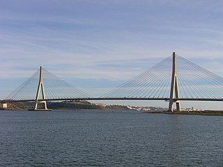
The Guadiana International Bridge is a bridge that crosses the Guadiana River connecting southern Spain and Portugal. It is the southernmost land crossing on the Portugal–Spain border. It is not split evenly between the two countries, with a greater share of it situated in Portugal. Completed in 1991, its structural type is a cable-stayed bridge, with a deck of prestressed concrete. The bridge was designed by the Portuguese Structural Engineer Professor José Luis Câncio Martins on behalf of Huarte S.A. and Teixeira Duarte. The bridge is open to vehicles only. It is the third longest bridge in Portugal and one of the longest in Spain.

The Brenner Autobahn refers to a major European truck route that connects Innsbruck in Austria to Verona in northern Italy.

The Algarve Football Cup or Algarve Trophy, previously known as Guadiana Trophy until 2013, is a pre-season friendly football tournament played in Algarve, Portugal. Benfica is the most successful team in the tournament, having won nine trophies in fourteen participations.
The 2005 Guadiana Trophy was a Portuguese football competition that took place between 28–30 July 2005 and featured the clubs Sporting Clube de Portugal, Vitória de Setúbal, Middlesbrough, and Real Betis. Sporting won in the final against Vitória de Setúbal.

The Autostrada A22 or Autobrennero or Autostrada del Brennero is one of the most important autostrada in Italy, as it connects Po Valley, the city of Modena and the Autostrada A1 to Austria through the Brenner Pass, located in the municipality of Brenner. The Autostrada A22 is 315 kilometres (196 mi) long. It is a part of the E45 European route. The operator of the road is Autostrada del Brennero S.p.A.. The Autostrada A22 is located in the regions of Emilia-Romagna, Lombardy, Veneto and Trentino-Alto Adige/Südtirol.

The Quarteira River is a small river in the Portuguese region of the Algarve. The river begins at the conflux of two tributary rivers a little north of the village of Paderne. The tributary rivers are the River de Alte and the River de Algibre.
The European route E1 in Portugal is a series of roads, part of the International E-road network running on a north south axis on the west coast. It starts at the Spanish border in the north at Valença going almost perfectly south passing by several major Portuguese cities like Porto and Lisbon until the border with Spain again at Castro Marim.

Linha do Algarve is a railway line in the region of Algarve, in southern Portugal, which connects the stations of Lagos to the west and Vila Real de Santo António to the east of the Portuguese region.
Infraestruturas de Portugal, S.A. (IP) is a state-owned company which resulted from the merger of Rede Ferroviária Nacional (REFER) and Estradas de Portugal (EP). It manages the Portuguese rail and road infrastructure.


