
Azad Jammu and Kashmir, abbreviated as AJK and colloquially referred to as simply Azad Kashmir, is a region administered by Pakistan as a nominally self-governing entity and constituting the western portion of the larger Kashmir region, which has been the subject of a dispute between India and Pakistan since 1947. Azad Kashmir also shares borders with the Pakistani provinces of Punjab and Khyber Pakhtunkhwa to the south and west, respectively. On its eastern side, Azad Kashmir is separated from the Indian union territory of Jammu and Kashmir by the Line of Control (LoC), which serves as the de facto border between the Indian- and Pakistani-controlled parts of Kashmir. Geographically, it covers a total area of 13,297 km2 (5,134 sq mi) and has a total population of 4,045,366 as per the 2017 national census.

The Neelum River, or Kishanganga River, is a river in the Kashmir region in the Indian subcontinent. It originates in Ganderbal district of Indian-administered Kashmir, flows through the Neelam Valley into Pakistani-administered Kashmir, where parts of its course fall along the Line of Control, before merging with the Jhelum River near the city of Muzaffarabad.

Neelum is a district of Pakistan-administered Azad Kashmir in the disputed Kashmir region. It is the northernmost of 10 districts located within the Pakistani-administered territory of Azad Kashmir. Taking up the larger part of the Neelum Valley, the district had a population of around 191,000 people. It was among the worst-hit areas of Pakistan during the 2005 Kashmir earthquake.
Athmuqam or Athmakam is a tehsil of Neelum District in Azad Kashmir, Pakistan. It is situated about 73 kilometres (45 mi) from Muzaffarabad. Athmuqam is the headquarters of Neelum District. Its population was 7,922 in 2017.

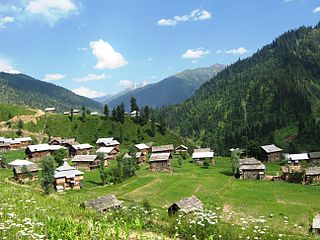
Kel is a village in Neelum Valley, Azad Kashmir, Pakistan.

Keran is a village and tourist resort in the Neelum Valley. It is located 93 kilometers (58 mi) from Muzaffarabad on the bank of the Neelum River at an altitude of 1,524 meters (5,000 ft). Neelam village is 2.5 kilometers (1.6 mi) away from Keran. The adjacent village on the other side of the Neelum River in Indian-administered Kashmir is also known as Keran.

Kutton is a village and a tourist resort in Neelam Valley of Azad Kashmir administered by Pakistan. It is located about 98 kilometres (61 mi) from Muzaffarabad . Kutton is accessible by Neelam road from Muzaffarabad branches off from Kundal Shahi.
Taobat is a village in Sharda Tehsil in Neelam Valley, Azad Kashmir, Pakistan. It is located 200 kilometers (120 mi) from Muzaffarabad and 39 kilometers (24 mi) from Kel. It is the last station in Neelam valley. It is also the nearest location from where Neelam River enters Pakistani territory and becomes River Neelum. In 1998 it had a population of 720.

Kundal Shahi is a village and tourist resort in the Neelum District in northern Azad Kashmir, Pakistan. It has a scattered settlement area, located on both sides of the Jagran Nallah River, at its confluence with the Neelum River. It is a few minutes walking distance from the Neelam Valley highway, some 74 km (46 mi) by road from Muzaffarabad, and a few kilometres away from the Line of Control between India– and Pakistan-administered Kashmir.
Upper Neelam is a village in Neelam District, Azad Kashmir, Pakistan. It is located 93 km (58 mi) from Muzaffarabad and 9 km (5.6 mi) from Athmuqam Tehsil on the bank of Neelum River at the altitude of 1,524 m (5,000 ft). Keran is 2.5 km away from here.

Dowarian is a village in Neelum Valley, Azad Kashmir, Pakistan. It is located 106 kilometers (66 mi) from Muzaffarabad and 22 kilometers (14 mi) from Athmuqam on the bank of Neelum River at the altitude of 1,615 meters (5,299 ft).

ChikarValley is a small town and hill station in Hattian Bala District of Azad Kashmir, Pakistan. It is located 46 kilometers (29 mi) from Muzaffarabad at the altitude of 1,607 meters (5,272 ft). It is the headquarters of Tehsil Chikar.
Dao Khan is a village and tourist spot in Leepa Valley, Hattian Bala District of Azad Kashmir. It is located 71 kilometers (44 mi) from Muzaffarabad and 4 kilometers (2.5 mi) from Reshian at the altitude of 2,490 meters (8,170 ft).

Arang Kel is a village and tourist spot in the Neelam valley of Azad Kashmir. It is located on the hilltop above Kel at an altitude of 8,379 feet (2,554 m).

Kotla is the name of a valley in Northern Bagh. The name of the main village of this valley is Kotla, on the basis of which the entire valley was named Kotla Valley. Kotla is a village and tourist resort in Bagh District, Azad Kashmir, Pakistan. Kotla is 6,560 feet (2,000 m) above sea level. Kotla contains pine trees that are hundreds of years old. It takes approximately 1 hour to drive from Bagh to Kotla.
Quaid-e-Azam Tourist Lodge, also known as the Barsala Tourist Lodge, Dak Bungalow, and Quaid-i-Azam Memorial Rest House, is a historic dak bungalow located in Kohala, Muzaffarabad District, Azad Kashmir. It is named after the first Pakistani governor-general, Muhammad Ali Jinnah known as Quaid-e-Azam, who resided there in 1944.

The northern part of Azad Jammu and Kashmir encompasses the lower part of the Himalayas, including Jamgarh Peak. However, Sarwali peak in the Neelum Valley is the highest peak in the state. Fertile, green, mountainous valleys are characteristic of Azad Kashmir's geography, making it one of the most beautiful regions on the subcontinent.

The Azad Kashmir Police(آزاد کشمیر پولیس) or Azad Jammu and Kashmir Police (AJKP) is responsible for law enforcement in the Azad Kashmir region administered by Pakistan. It is presently headed by Inspector-General of Police, Sohail Habib Tajik (PSP), and headquartered in the Central Police Office (CPO) Muzaffarabad, Azad Kashmir.

Kashmiris in Azad Kashmir are the ethnic Kashmiri people who reside in Azad Kashmir, a territory which constitutes part of Pakistani-administered Kashmir since the end of the First Kashmir War. Their demographic includes up to 40,000 registered Kashmiri refugees who have fled the Kashmir Valley, located in Indian-administered Kashmir, to Pakistan since the late 1980s due to conflict in the region. As of 2010, only around 60 percent of Kashmiri refugees had acquired Pakistani citizenship.