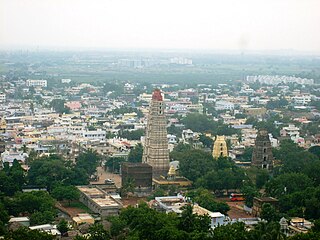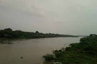
Nellore is a city located on the banks of Penna River, in Nellore district of the Indian state of Andhra Pradesh. It serves as the headquarters of the district, as well as Nellore mandal and Nellore revenue division. It is the fourth most populous city in the state. It is at a distance of 700 km from state's Executive capital Visakhapatnam and about 170 km north of Chennai, Tamilnadu and also about 380 km east-northeast of Bangalore, Karnataka. Nellore City accounts for 65% of the urban population of Nellore District.

Mangalagiri is a model town in Guntur district situated between the twin cities of Vijayawada and Guntur of the Indian state of Andhra Pradesh. It is a major suburb region of the cities of Vijayawada and Guntur. It is currently the 31st most populous city of Andhra Pradesh. The town is the headquarters of Mangalagiri mandal under Guntur revenue division. It is situated on National Highway 16 between Vijayawada and Guntur. The town was known to have existed since 225 B.C..

Srikakulam is a city and the headquarters of Srikakulam district in the Indian state of Andhra Pradesh. As of 2011 census, it has a population of 146,988. There are many other places of Buddhist Tourism such as Salihundam, Calinga Patnam, Dabbaka Vaani Peta, Nagari Peta, Jagati Metta, Singupuram etc. in Srikakulam District. The Buddhist heritage site of Salihundam has some unique features. It has a beautiful star atop a stupa, rock cut massive stupaas inside chaitya grihas, brick stupas with wheel pattern plan, votive stupas, inscriptions on the steps leading to the stupas and museum housing over two dozen sculpted statue and figurines of Buddha, Jain Teerthankars and other deities

Vizianagaram is a city and the headquarters of Vizianagaram district in the Indian state of Andhra Pradesh. It is central Eastern Ghats, about 24 km (15 mi) west of the Bay of Bengal and 40 km (25 mi) north-northeast of Visakhapatnam. The city has a population of 2,28,025 and was the headquarters of the rajas of Vizianagaram, who played a notable role in the history of Andhra Pradesh in the 18th century and were patrons of education and the fine arts.

Kalyandurg is a town in Anantapur district of the Indian state of Andhra Pradesh. It is the headquarters for Kalyandurg mandal and Kalyandurg revenue division. The discovery of diamond-bearing Kimberlites in Kalyandurg area, is one of the clusters that has been discovered.

Chittoor district, is one of the four districts in the Rayalaseema region of the Indian state of Andhra Pradesh. The district headquarters is located at Chittoor. It has a population of 4,170,468 according to 2011 census of India. Chittoor district has many major temples including Tirupati, Srikalahasti, Kanipakam, and other temples. It lies in the Poini river valley of southernmost Andhra Pradesh along the Chennai – Bangalore section of Chennai-Mumbai highway. Chittoor district is a major market centre for mangoes, grains, sugarcane, and peanuts. Sricity integrated business city lies in Satyavedu mandal; it acts as a major industrial hub for Chittoor district as well as Andhra Pradesh as a whole.

Srikakulam district is one of the nine districts in the Coastal Andhra region of the Indian state of Andhra Pradesh, with its headquarters located at Srikakulam. It is one of the nine coastal districts, located in the extreme northeastern direction of the state. It was formerly known as Chicacole.

Guntakal is a town in Anantapur district of the Indian state of Andhra Pradesh. It is the headquarters of Guntakal mandal in Anantapur revenue division.It is also the headquarters of the Guntakal Railway Division in South Central Railway.

Pedana is a municipality and the headquarters of Pedana mandal under Machilipatnam revenue division of Krishna district of the Indian state of Andhra Pradesh. It is located at a distance of 8 km (5.0 mi) from the district headquarters, Machilipatnam.

Rayadurga is a small city in Anantapur District in the Indian state of Andhra Pradesh. It is governed by a municipal council. Rayadurga is known for its production of Textile goods and textile manufacturing industry. Rayadurga is in Southern India about 451.6 kilometres from Hyderabad. Rayadurga is now slowly developing with proper transportation, modern amenities in the city. Rayadurga is well connected with other cities in Andhra Pradesh and India through well infrastructure and its connection to NH 544DD Highway. The nearest airport is Ballari Airport in Karnataka followed by Kurnool, Putaparthi and Bengaluru. Rayadurg also has a train station with major stations nearby such as Ballari, Guntakal, Gooty & Anantapur.

Salur or Saluru is a municipal town and mandal headquarters in Vizianagaram district, of the Indian state of Andhra Pradesh.

Venkatagiri is a town in Nellore district of the Indian state of Andhra Pradesh. It is a municipality and mandals headquarters of Venkatagiri mandal. Venkatagiri's old name is "Kali Mili". It is famous for its Handloom Cotton Sarees. Venkatagiri is a place for history and handlooms. It was part of a small kingdom that was integrated into the Indian Republic.

Palamaner or Palamaneru is a town in Chittoor district of the Indian state of Andhra Pradesh. It is the mandal headquarters of Palamaner mandal in Madanapalle revenue division

Palasa is a town in Srikakulam district of the Indian state of Andhra Pradesh. It is a municipality and the mandal headquarters of Palasa mandal. It is located near to the National Highway 16 between Srikakulam and Berhampur. Along with its twin town Kasibugga

Paderu is a village and a Mandal in Visakhapatnam district in the state of Andhra Pradesh in India.

Piduguralla is a town in Guntur district of the Indian state of Andhra Pradesh. It is one of the 12 municipalities in the district. The town is the headquarters of Piduguralla mandal and administered under Gurazala revenue division. The town is also known as Lime City of India as there are abundant reserves of limestone.
Koya is a South-Central Dravidian language of the Gondi–Kui group spoken in central and southern India. It is the native language of the Koya people. It is sometimes described as a dialect of Gondi, but it is mutually unintelligible with Gondi dialects.
Yanamalakuduru is a census town in Krishna district of the Indian state of Andhra Pradesh. It is located in Penamaluru mandal of Vijayawada revenue division. As per the G.O. No. M.S.104 (dated:23-03-2017), Municipal Administration and Urban Development Department, it became a part of Vijayawada metropolitan area.
The Bagata are a designated Scheduled Tribe in the Indian states of Andhra Pradesh and Odisha.

As per the 2011 census of India, Andhra Pradesh has an overall literacy rate of 67.35%, significantly lower than the overall national average of 74.04%. Among the Indian states and union territories, it stands at 32nd position. During the same census, there are a total of 29,859,982 literates: 16,549,514 males and 13,310,468 females. In terms of district-wise literates, East Godavari has the most with 3,348,077 and Vizianagaram has the least with 1,238,388. While, in terms of district-wise literacy rates, West Godavari stands top with 74.32% and Vizianagaram at bottom with 58.89%. The government also implements fee reimbursement scheme for the economically backward sections of the state.


