Related Research Articles
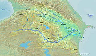
Atil, also Itil, was the capital of the Khazar Khaganate from the mid-8th century to the late 10th century. Known to have been situated on the Silk Road, in the vicinity of the Caspian Sea, its precise location has long been unknown.

Samandar was a city in Khazaria, on the western shore of the Caspian Sea, in what is now Daghestan. At some later date, it may have been moved inland to some areas near the present-day village of Shelkovskaya in the modern Chechen Republic.

Gorgan is a city in the Central District of Gorgan County, Golestan province, Iran, serving as capital of the province, the county, and the district. It lies approximately 400 km (250 mi) to the northeast of the national capital Tehran, and some 30 km (19 mi) away from the Caspian Sea.

Gilan province is one of the 31 provinces of Iran, in the northwest of the country. Its capital is the city of Rasht. The province lies along the Caspian Sea, in Iran's Region 3, west of the province of Mazandaran, east of the province of Ardabil, and north of the provinces of Zanjan and Qazvin. It borders Azerbaijan in the north.

Khwarazm or Chorasmia is a large oasis region on the Amu Darya river delta in western Central Asia, bordered on the north by the (former) Aral Sea, on the east by the Kyzylkum Desert, on the south by the Karakum Desert, and on the west by the Ustyurt Plateau. It was the center of the Iranian Khwarezmian civilization, and a series of kingdoms such as the Afrighid dynasty and the Anushtegin dynasty, whose capitals were Kath, Gurganj and—from the 16th century on—Khiva. Today Khwarazm belongs partly to Uzbekistan and partly to Turkmenistan.

Golestan Province is one of the 31 provinces of Iran, located in the northeast of the country and southeast of the Caspian Sea. Its capital is the city of Gorgan, formerly called Esterabad until 1937. Golestan was split off from Mazandaran Province in 1997.
Ahmad ibn Rusta Isfahani, more commonly known as ibn Rusta, was a tenth-century Muslim Persian explorer and geographer born in Rosta, Isfahan in the Abbasid Caliphate. He wrote a geographical compendium known as the Kitāb al-A‘lāq al-Nafīsa.
Arran, also known as Aran, was a geographical name used in ancient and medieval times to signify a historically-Iranian region which lay within the triangle of land, lowland in the east and mountainous in the west, formed by the junction of the Kura and Aras rivers, including the highland and lowland Karabakh, Mil plain and parts of the Mughan plain. In pre-Islamic times, it corresponded roughly to the territory of the modern-day Republic of Azerbaijan. The term is the Middle Persian equivalent to the Greco-Roman Albania. It was known as Aghvania, Alvan-k in Armenian, and Al-ran in Arabic.
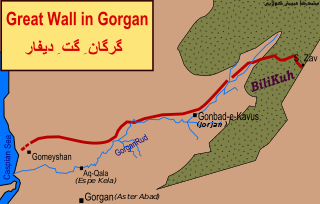
The Great Wall of Gorgan is a Sasanian-era defense system located near modern Gorgan in the Golestān Province of northeastern Iran, at the southeastern corner of the Caspian Sea. The western, Caspian Sea, end of the wall is near the remains of the fort at: 37.13981°N 54.1788733°E; the eastern end of the wall, near the town of Pishkamar, is near the remains of the fort at: 37.5206739°N 55.5770498°E. The title coordinate is for the location of the remains of a fort midway along the wall.
Abu Sahl 'Isa ibn Yahya al-Masihi al-Jurjani was a Christian Persian physician, from Gorgan, east of the Caspian Sea, in Iran.
Abu'l-Qasim Ubaydallah ibn Abdallah ibn Khordadbeh, commonly known as Ibn Khordadbeh, was a high-ranking bureaucrat and geographer of Persian descent in the Abbasid Caliphate. He is the author of the earliest surviving Arabic book of administrative geography.

The Gates of Alexander, also known as the Caspian Gates, are one of several mountain passes in eastern Anatolia, the Caucasus, and Persia separating the Greco-Roman world from the Persian world. They are often imagined as an actual fortification, or as a symbolic boundary separating the civilized from the uncivilized world. The original Gates of Alexander were just south of the Caspian Sea, at Rhagae, where Alexander crossed while pursuing Darius III. The name was transferred to passes through the Caucasus, on the other side of the Caspian, by the more fanciful historians of Alexander.

Salmas is a city in the Central District of Salmas County, West Azerbaijan province, Iran, serving as capital of both the county and the district. It is northwest of Lake Urmia, near Turkey.

Barda is a city and the capital of the Barda District in Azerbaijan, located south of Yevlax and on the left bank of the Tartar river. It served as the capital of Caucasian Albania by the end of the 5th-century. Barda became the chief city of the Islamic province of Arran, the classical Caucasian Albania, remaining so until the tenth century.

The Caspian expeditions of the Rus' were military raids undertaken by the Rus' between the late 9th century and c. 1041 on the Caspian Sea shores, of what are nowadays Iran, Dagestan, and Azerbaijan. Initially, the Rus' appeared in Serkland in the 9th century travelling as merchants along the Volga trade route, selling furs, honey, and slaves. The first small-scale Viking raids took place in the late 9th and early 10th century. The Rus' undertook the first large-scale expedition in 913; having arrived on 500 ships, they pillaged in the Gorgan region, in the territory of present-day Iran, and more to the west, in Gilan and Mazandaran, taking slaves and goods. On their return, the northern raiders were attacked and defeated by the Khazars in the Volga Delta, and those who escaped were killed by the local tribes in the middle Volga.
In the Middle Ages, the Volga trade route connected Northern Europe and Northwestern Russia with the Caspian Sea and the Sasanian Empire, via the Volga River. The Rus used this route to trade with Muslim countries on the southern shores of the Caspian Sea, sometimes penetrating as far as Baghdad. The powerful Volga Bulgars formed a seminomadic confederation and traded through the Volga river with Viking people of Rus' and Scandinavia and with the southern Byzantine Empire Furthermore, Volga Bulgaria, with its two cities Bulgar and Suvar east of what is today Moscow, traded with Russians and the fur-selling Ugrians. Chess was introduced to Medieval Rus via the Caspian-Volga trade routes from Persia and Arabia.

The Shirvanshahs were the rulers of Shirvan from 861 to 1538. The first ruling line were the Yazidids, an originally Arab and later Persianized dynasty, who became known as the Kasranids. The second ruling line were the Darbandi, distant relatives of the Yazidids/Kasranids.
Rusʹ Khaganate, or kaganate of Rus is a name applied by some modern historians to a hypothetical polity suggested to have existed during a poorly documented period in the history of Eastern Europe between c. 830 and the 890s.

The defense lines of the Sasanians were part of their military strategy and tactics. They were networks of fortifications, walls, and/or ditches built opposite the territory of the enemies. These defense lines are known from tradition and archaeological evidence.
Al-Ubulla, called Apologou by the Greeks in the pre-Islamic period, was a port city at the head of the Persian Gulf east of Basra in present-day Iraq. In the medieval period, it served as Iraq's principal commercial port for trade with India.
References
- 1 2 3 4 5 Bosworth, C. E. "Abaskūn Archived October 9, 2007, at the Wayback Machine ". Encyclopaedia Iranica. Accessed on June 6, 2007.
- ↑ The Center for the Great Islamic Encyclopedia(in Persian) Archived November 14, 2007, at the Wayback Machine
- ↑ Golden, P.B. (2006) "Rus." Encyclopaedia of Islam (Brill Online). Eds.: P. Bearman, Th. Bianquis, C.E. Bosworth, E. van Donzel and W.P. Heinrichs. Brill.