
Butte County is a county located in the northern central part of the U.S. state of California. In the 2020 census, its population was 211,632. The county seat is Oroville.

Scouting in Montana has a long history, from the 1910s to the present day, serving thousands of youth in programs that suit the environment in which they live.
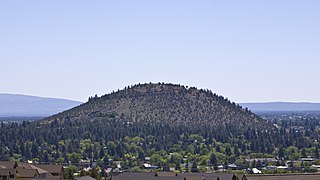
Pilot Butte is a lava dome that was created from an extinct volcano located in Bend, Oregon. It is a cinder cone butte which rises nearly 500 feet (150 m) above the surrounding plains. Bend is one of six cities in the United States to have a volcano within its boundaries. The other examples are Mount Tabor in Portland, Oregon, Jackson Volcano in Jackson, Mississippi, Diamond Head in Honolulu, Glassford Hill in Prescott Valley and Pilot Knob in Austin, Texas.
Centerville is an unincorporated community in Butte County, California along Butte Creek. It was midway between Helltown and Diamondville. The area is about one and three quarters miles, straight-line distance, west of Paradise.

Blacktail Butte is a butte mountain landform rising from Jackson Hole valley in Grand Teton National Park in the U.S. state of Wyoming. Blacktail Butte was originally named Upper Gros Ventre Butte in an early historical survey conducted by the U.S. Geological Survey. Most of Blacktail Butte is densely forested with a mixed fir forest of lodgepole pine, Douglas fir and Engelmann spruce, with scattered pockets of aspen. There are several large sedimentary rock outcroppings, which are used by rock climbers. This butte is a principal landmark in Jackson Hole, with much of the Jackson Hole valley floor and many portions of the Teton Range visible from its hillsides.

Butte des Morts is an unincorporated census-designated place in the town of Winneconne and Oshkosh, in Winnebago County, Wisconsin, United States.
Big Bend is an unincorporated community in Butte County, California, United States. It lies at an elevation of 2310 feet. A post office operated in Big Bend from 1883 to 1891.
Hurleton is an unincorporated community in Butte County, California. It is located 7.5 miles (12.1 km) north of Bangor. It lies at an elevation of 1598 feet.
Sunnyslope is an unincorporated community in Butte County, California, United States.
Griffin Butte, at 8,411 feet (2,564 m) above sea level is a peak in the Smoky Mountains of Idaho. The peak is located in Sawtooth National Forest in Blaine County northwest of Ketchum. It is located in the watershed of the Big Wood River. It is about 1.75 mi (2.82 km) west of Idaho State Highway 75. No roads or trails go to the summit.
Tongue Butte is a summit in Sheridan County, Wyoming, in the United States. With an elevation of 7,946 feet (2,422 m), Tongue Butte is the 885th tallest mountain in Wyoming.
Elephant Butte is a summit that is now in the Elephant Butte Reservoir and within the Elephant Butte Lake State Park in Sierra County, New Mexico. It has an elevation of 4,639 feet (1,414 m). It was named for its shape, which is said to look like an elephant.

Butte Falls is a waterfall located near the town of Butte Falls in Jackson County, in the U.S. state of Oregon. It totals 15 feet (4.6 m) tall in one wide cascade and is runnable by whitewater kayak on the right side shooting into a large bowl. In the past, the waterfall was the site of a water-driven sawmill that led to the town of Butte Falls.
Bieberstedt Butte is a summit in the U.S. state of Oregon. The elevation is 5,259 feet (1,603 m).
Coker Butte is a summit in the U.S. state of Oregon. The elevation is 1,667 feet (508 m).
Fredenburg Butte is a summit in the U.S. state of Oregon. The elevation is 4,298 feet (1,310 m).
Gardener Butte is a summit in the U.S. state of Oregon. The elevation is 2,940 feet (900 m).
Rancheria Creek is a stream in the U.S. state of Oregon. It is a tributary to South Fork Big Butte Creek.
Songer Butte is a summit in the U.S. state of Oregon. The elevation is 2,736 feet (834 m).
Wagner Butte is a summit in the U.S. state of Oregon. The elevation is 7,251 feet (2,210 m).
