Abisko National Park

Last updated
Abisko National Park
Abisko nationalpark
Lapporten 2.jpg
Lapporten in the Abisko National Park
Location Norrbotten County, Sweden
Nearest city Kiruna
Coordinates 68°19′N18°41′E / 68.317°N 18.683°E / 68.317; 18.683 Coordinates: 68°19′N18°41′E / 68.317°N 18.683°E / 68.317; 18.683
Area77 km2 (30 sq mi) [1]
Established1909 [1]
Governing body Naturvårdsverket

Abisko National Park (Swedish : Abisko nationalpark) is a National Park in Sweden, established in 1909.

Contents

Geography

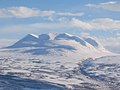
Abisko is situated in the Swedish province of Lapland near the Norwegian border (distance approx. 37 km (23 mi) by railway), and belongs to Kiruna Municipality, Sweden's northernmost and largest municipality. It begins at the shores of Torneträsk, one of Sweden's largest lakes where the village of Abisko is located, and extends some 15 km (9.3 mi) to the south-west. It is situated about 195 km (121 mi). north of the Arctic Circle. The area of the park is 77 km2 (30 sq mi)

Permafrost is common in the national park, though permafrost at lower elevations is disappearing because of global warming and increased snowfall. [2]

History

The park was proposed and established in 1909, the same year Sweden's first laws on nature conservation were created, by a group of prominent Swedish scientists, including the well-known geologist Fredrik Svenonius  [ fi ].

The purpose of the Abisko National Park was to "preserve an area with northern Nordic fell nature in its original condition and as a reminiscence for scientific research". The region has proved to be of much scientific interest, as is shown by the Abisko Scientific Research Station which exists to study the area. Furthermore, the national park was intended to be a prominent tourist attraction.

Abisko is also home to the Abisko Scientific Research Station, first established in 1903 approximately 31 km west of Abisko in Vassijaure. After a fire in 1910 a new station was built in its present location in Abisko in 1912 and opening in 1913. The research station was incorporated within the Royal Swedish Academy of Sciences in 1935. It is used primarily for biological, climate, ecological, environmental, and geological research and contains on-site laboratories as well as off-site field research stations.

Tourism

The 440 km (270 mi) long Kungsleden hiking trail, which follows the Scandinavian mountain range, starts (or ends) at the Abisko Turiststation (consisting of a railway station of the same name and the Abisko Youth Hostel) (approx. 4 km (2.5 mi) west of the village itself) and follows through the national park. The Nordkalottruta uses trails of the park as part of its longer passage. The Abisko Turiststation, run by the Svenska Turistföreningen (STF), houses many visitors to the park and provides lodging, food, and other amenities, and is one of many similar facilities located periodically along the Kungsleden trail. The national park is known for its cross-country skiing opportunities, snowshoeing, and other winter sports (Mount Nuolja and nearby Björkliden provides backcountry skiing and freeriding opportunities). As its location is 195 km north of the Arctic Circle, summer hikers enjoy the midnight sun, while winter visitors may find the light pollution-free location ideal for viewing the aurora borealis.

Transportation

Daily passenger electric trains run by SJ AB connect Stockholm with the Norwegian city of Narvik, stopping at both the Abisko village (the name of that railway station is Abisko Östra [east]) and the Abisko Turiststation. Additional regional trains provide links within the Kiruna-Narvik stretch. Abisko is also reachable by car via the highway E10 which links Kiruna and Narvik since early 1980s. Other local forms of local transportation include hiking and dog-sledding in winter. A chair-lift provides access to the summit of nearby Mt. Nuolja.

Animals

There are many species of birds in the park.

Of the mammals, smaller ones like the marten, stoat, squirrel, the fell lemming and similar are common parts of the fauna. Of larger animals, the moose and reindeer are common, and moose droppings and tracks are found; however, wolverines, Arctic foxes, lynx and bears are only seen sporadically.

Related Research Articles

Kiruna Mining town in Northern Sweden

Kiruna is the northernmost town in Sweden, situated in the province of Lapland. It had 17,002 inhabitants in 2016 and is the seat of Kiruna Municipality in Norrbotten County. The city was originally built in the 1890s to serve the Kiruna Mine.

Tourism in Sweden comprised a relatively small part of the Swedish economy in 2011 at 2.9% of the country's GDP; at this time, tourism generated 264 billion Swedish krona, 98.8 billion of which was foreign-visitor expenditure in Sweden. 7.1% of Swedish household income is spent on domestic tourism.

Narvik Municipality in Nordland, Norway

Narvik  is the third-largest municipality in Nordland county, Norway, by population. The administrative centre of the municipality is the town of Narvik. Some of the notable villages in the municipality include Ankenesstranda, Ballangen, Beisfjord, Bjerkvik, Bjørnfjell, Elvegård, Kjøpsvik, Skjomen, Håkvik, Hergot, Straumsnes, and Vidrek. The Elvegårdsmoen army camp is located near Bjerkvik.

Kebnekaise Swedens highest mountain

Kebnekaise is the highest mountain in Sweden. The Kebnekaise massif, which is part of the Scandinavian mountain range, has two main peaks. The glaciated southern peak used to be the highest at 2,120 metres (6,960 ft) above sea level, but has shrunk by 24 meters during the last 50 years, making the northern icefree peak at 2,096.8 metres (6,879 ft) the highest. Kebnekaise lies in Swedish Lapland, about 150 kilometres (93 mi) north of the Arctic Circle and west of Kiruna near the Kungsleden hiking trail between Abisko and Hemavan.

Torne (river) River in northern Sweden and Finland

The Torne, also known as the Tornio, is a river in northern Sweden and Finland. For approximately half of its length it defines the border between these two countries. It rises at Lake Torne near the border with Norway and flows generally southeast for a distance of 522 kilometres (324 mi) into the Gulf of Bothnia. It is the largest river in Norrbotten both by length and by watershed area.

<span class="mw-page-title-main">Torneträsk</span> Lake in Kiruna municipality in Sweden

Torneträsk or Torne träsk is a lake in Kiruna Municipality, Lapland, Norrbotten County in Sweden, in the Scandinavian mountain range. Träsk is the local word for lake. It is the sixth largest lake in Sweden, with a total area of 330 square kilometres and a length of 70 kilometres. The lake drains to the south-east through Torne älv. South-west of the lake lie the Abisko National Park and the UNESCO World Heritage Site Laponian area.

<span class="mw-page-title-main">Abisko</span> Village in Kiruna Municipality, Sweden

Abisko is a village in Sápmi (Lapland), in northern Sweden, roughly 250 km within the Arctic Circle, and near Abisko National Park, located 4 km west of the village. It had 85 inhabitants as of 2005.

<span class="mw-page-title-main">Ofoten Line</span>

The Ofoten Line is a 43-kilometre (27 mi) railway line in Narvik, Norway. It runs from the Port of Narvik to Riksgränsen on the Norway–Sweden border, where the line continues as the Ore Line via Kiruna and Gällivare to Luleå. The Ofoten Line is single track, electrified at 15 kV  16.7 Hz AC and has seven stations. The line only connects to the rest of the Norwegian railway network via Sweden. The main traffic is up to 12 daily freight trains operated by Malmtrafik that haul iron ore from Sweden to Narvik. In addition, CargoNet operates container trains, branded as the Arctic Rail Express (ARE), and SJ operates passenger trains, including a night train to Stockholm.

Padjelanta National Park National park in Sweden

Padjelanta is a national park in Norrbotten County in northern Sweden. Established in 1963, it is the largest national park in Sweden with an area of 1,984 km2 (766 sq mi), and part of the UNESCO World Heritage Site Laponia established in 1996.

Pieljekaise National Park

Pieljekaise is a Swedish national park. It lies about 10 km (6.2 mi) south of Jäkkvik in Arjeplog Municipality, Lappland. The park consists largely of birch woods.

<span class="mw-page-title-main">Iron Ore Line</span>

The Iron Ore Line is a 398-kilometre (247 mi) long railway line between Riksgränsen and Boden in Norrbotten County, Sweden, owned by Trafikverket. The line also contains two branches, from Kiruna to Svappavaara and from Gällivare to Koskullskulle. The term is often colloquially used to also include the Ofoten Line, from Riksgränsen to Narvik in Norway, and the northernmost part of the Main Line Through Upper Norrland from Boden to Luleå. The railway from Narvik to Luleå is 473 kilometres (294 mi) long.

<span class="mw-page-title-main">Abisko Scientific Research Station</span> Research station in Sweden

The Abisko Scientific Research Station (ANS) is a field research station managed by the Swedish Polar Research Secretariat. Situated on the south shore of Lake Torneträsk, it lies at the edge of the Abisko National Park. The station conducts ecological, geological, geomorphological and meteorological research in subarctic environments and each year about 500 scientists visit from all over the world. The varied geological, topographical and climatic conditions of the area allow it to be inhabited by a range of flora and fauna. These features, which have caused the area to be given National Park status, also make it an important place for scientific research, particularly of alpine and subalpine ecosystems.

<span class="mw-page-title-main">Kungsleden</span> Hiking trail in Sweden

Kungsleden is a hiking trail in northern Sweden, approximately 440 kilometres (270 mi) long, between Abisko in the north and Hemavan in the south. It passes through, near the southern end, the Vindelfjällen Nature Reserve, one of the largest protected areas in Europe. In the winter Kungsleden is a ski trail with approximately the same route.

Pingo Canadian Landmark Natural area near Tuktoyaktuk, Northwest Territories, Canada

Pingo Canadian Landmark, also known as Pingo National Landmark, is a natural area protecting eight pingos near Tuktoyaktuk, Northwest Territories. It is in a coastal region of the Arctic Ocean which contains approximately 1,350 Arctic ice dome hills—approximately one quarter of the world's pingos.

Nikkaluokta Village in Gällivare, Norrbotten, Sweden

Nikkaluokta is a Swedish Sami village in Norrbotten County. The village belongs to Gällivare Municipality, bordering Kiruna Municipality, the closest urban area some 60 kilometers away. In its vicinity lie the areas of two Sami communities, Laevas and Girjas, who still herd semi-domesticated reindeer in the region.

E1 European long distance path

The E1 European long-distance path, or just E1 path, is one of the European long-distance paths designated by the European Ramblers' Association. It has a total length of some 7,000 kilometres (4,300 mi). It begins in Norway at Nordkapp, and crosses the Kattegat between Sweden and Denmark by ferry. It passes through Denmark, Germany, and Switzerland to finish at Scapoli, Italy. This path was extended southwards to Sicily, in Italy in 2018.

Storflaket

Storflaket is a permafrost plateau peat bog on the southern shore of Torneträsk lake, in northern Sweden. Storflaket together with Stordalen is one of the main sites of studying palsas and methane emissions in Scandinavia. The bog received its name, Storflaket, due to its relatively large extent and flat surface during the buildings works of Malmbanan railroad in early 20th century.

Kvikkjokk Place in Lapland, Sweden

Kvikkjokk is a small village situated in Jokkmokk Municipality, Norrbotten County, Sweden. It is located 120 km northwest of Jokkmokk. Several hiking trails start in Kvikkjokk. Kungsleden passes through the village and it is a popular starting point for hikers going into Sarek National Park.

Stora Blåsjön

Stora Blåsjön is a hamlet in Frostviken, Strömsund Municipality, Jämtland, Sweden. The area is known for its wilderness and skiing opportunities. Vildmarksvägen, a 360 kilometres (220 mi) wilderness road, bypasses the hamlet. Stora Blåsjön has a moose farm and a school museum.

Climate Impacts Research Centre Swedish research center

Climate Impacts Research Centre (CIRC) is a research institute based at the Department of ecology and environmental science (EMG) at Umeå University, Sweden, but primarily operative at Abisko Scientific Research Station which is run by the Swedish Polar Research Secretariat.

References

  1. 1 2 "Abisko National Park". Naturvårdsverket. Archived from the original on 18 February 2009. Retrieved 2009-02-27.
  2. Johansson, Margareta; Christensen, Torben R.; Akerman, H. Jonas; Callaghan, Terry V. (2006). "What Determines the Current Presence or Absence of Permafrost in the Torneträsk Region, a Sub-arctic Landscape in Northern Sweden?". Ambio: A Journal of the Human Environment . 35 (4): 190–197. doi:10.1579/0044-7447(2006)35[190:WDTCPO]2.0.CO;2.