
The Aletsch Glacier or Great Aletsch Glacier is the largest glacier in the Alps. It has a length of about 23 km (14 mi) (2014), has about a volume of 15.4 km3 (3.7 cu mi) (2011), and covers about 81.7 km2 (2011) in the eastern Bernese Alps in the Swiss canton of Valais. The Aletsch Glacier is composed of four smaller glaciers converging at Konkordiaplatz, where its thickness was measured by the ETH to be still near 1 km (3,300 ft). It then continues towards the Rhône valley before giving birth to the Massa. The Aletsch Glacier is – like most glaciers in the world today – a retreating glacier. As of 2016, since 1980 it lost 1.3 kilometres (0.81 mi) of its length, since 1870 3.2 kilometres (2.0 mi), and lost also more than 300 metres (980 ft) of its thickness.

The Cairngorms are a mountain range in the eastern Highlands of Scotland closely associated with the mountain Cairn Gorm. The Cairngorms became part of Scotland's second national park on 1 September 2003. Although the Cairngorms give their name to, and are at the heart of, the Cairngorms National Park, they only form one part of the national park, alongside other hill ranges such as the Angus Glens and the Monadhliath, and lower areas like Strathspey.

The Twelve Bens or Twelve Pins, also called the Benna Beola is a mountain range of mostly sharp-peaked quartzite summits and ridges in the Connemara National Park in County Galway, in the west of Ireland. The widest definition of the range includes the Garraun Complex to the north as well as several isolated peaks to the west, and is designated a 16,163-hectare (39,940-acre) Special Area of Conservation.

Slacklining refers to the act of walking, running or balancing along a suspended length of flat webbing that is tensioned between two anchors. Slacklining is similar to slack rope walking and tightrope walking. Slacklines differ from tightwires and tightropes in the type of material used and the amount of tension applied during use. Slacklines are tensioned significantly less than tightropes or tightwires in order to create a dynamic line which will stretch and bounce like a long and narrow trampoline. Tension can be adjusted to suit the user, and different webbing may be used in various circumstances.
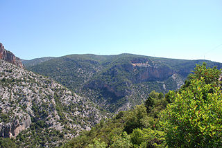
Parnon or Parnonas or Malevos (Μαλεβός) is a mountain range, or massif, on the east of the Laconian plain and the Evrotas valley. It is visible from Athens above the top of the Argive mountains. The western part is in the Laconia prefecture and the northeastern part is in the Arcadia prefecture. The Parnon range separates Laconia from Arcadia. Its summit offers panoramic views of southeastern Arcadia and South Kynouria and much of Laconia that includes the northern and the central portions and reaches as far as the Taygetos mountains. It also views a part of the central Arcadia and the southern Argolis prefectures. It views the Myrtoan and the Laconian Gulfs.

A Tyrolean traverse is a method of crossing through free space between two high points on a rope without a hanging cart or cart equivalent. This is used in a range of mountaineering activities: rock climbing, technical tree climbing, caving, water crossings and mountain rescue. A zip-line is in essence a Tyrolean traverse which is traveled down quickly with the assistance of gravity. Several sources claim that the name comes from the Tyrolean Alps, where climbers are said to have developed the system in the late nineteenth and early twentieth centuries.

Alto Campoo is a ski resort in the Cantabrian Mountains of northern Spain. The resort is located in the Cantabrian comarca of Campoo. The source of the river Ebro is near the resort in the town of Fontibre.
Robert John Slater was an American mountaineer known for his first ascent of the big wall route Wyoming Sheep Ranch on El Capitan. A tireless outdoor recreationalist, Slater built up an impressive climbing resume during his college years and later as he worked as a trader on the Chicago Board of Trade and for Goldman Sachs. He died on August 13, 1995, while descending from the summit of K2.
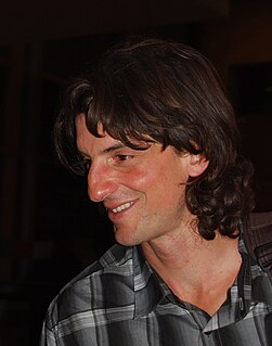
Dean Spaulding Potter was an American free climber, alpinist, BASE jumper, and highliner. He completed many hard first ascents, free solo ascents, speed ascents, and enchainments in Yosemite National Park and Patagonia. In 2015, he died in a wingsuit flying accident in Yosemite National Park.
The High Line Canal (HLC) is a man-made waterway, used for irrigation and recreation, that serves the Denver-Aurora metropolitan area. It begins at a diversion dam on the South Platte River, some 1.8 miles (2.9 km) above the mouth of Waterton Canyon. From its headgate, the HLC runs generally northeast for 66 miles (106 km), passing through Douglas, Arapahoe, Denver, and Adams Counties.
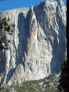
Lost Arrow Spire is a detached pillar in Yosemite National Park, in Yosemite Valley, California, located immediately adjacent to Upper Yosemite Falls. The structure includes the Lost Arrow Spire Chimney route which is recognized in the historic climbing text Fifty Classic Climbs of North America. The last two pitches of Lost Arrow Spire Chimney are called the Lost Arrow Spire Tip and completes the detached portion of the spire. The Tip route is often reached by rappelling into an area known as The Notch. Once the route is completed climbers will often return to the main wall via a dramatic and famous Tyrolean traverse.

Pindus National Park, also known as Valia Calda, is a national park in mainland Greece, situated in an isolated mountainous area at the periphery of West Macedonia and Epirus, in the northeastern part of the Pindus mountain range. It was established in 1966 and covers an area of 6,927 hectares. The park's core zone, 3,360 hectares, covers the greatest part of the Valia Calda valley and the slopes of the surrounding peaks.

The Jungfrau-Aletsch protected area is located in south-western Switzerland between the cantons of Berne and Valais. It is a mountainous region in the easternmost side of the Bernese Alps, containing the northern wall of Jungfrau and Eiger, and the largest glaciated area in western Eurasia, comprising the Aletsch Glacier. The Jungfrau-Aletsch protected area is the first World Natural Heritage site in the Alps; it was inscribed in 2001.
Cullahill Mountain is listed as a marilyn hill and a Special Area of Conservation in County Laois, Ireland. Cullahill with an elevation of 313 m (1,027 ft) gives its name to the local townland. It is also called Knockmannon Hill.
Kärkevagge is a short valley in Kiruna Municipality, Sweden. It is easily accessed by a good path from the E10 Kiruna-Narvik highway. Rissajaure, the clearest lake in Sweden, is located at the head of the valley. Karkevagge is noted for the Giant Boulder Deposit (GBD) which fills it with huge jumbled blocks, some the size of houses. One of Sweden's leading geoscientists, Anders Rapp, a world pioneer of quantitative geomorphology, studied the valley for 10 years. He suggested that the parallel rows of blocks had descended in waves from the valleyside cliffs. He estimated the volume of the GBD at 50 million cubic metres. However a large angular cavity beside Rissajaure has a volume of 42 million cubic metres. The GBD probably descended from it as a rock avalanche and spread down the valley on a glacier, giving it a moraine-like form and visual unity as seen from the air.

Andy Lewis, is a professional performer and speaker, stunt/safety coordinator, Tandem BASE jumper, slackliner, and extreme sports athlete. Lewis started a Tandem BASE Jumping Company in 2018 called “BASE Jump Moab" and is most famous for his efforts as a slackliner. Lewis has completed numerous accomplishments as a highliner and trickliner, and is also a distinguished BASE jumper and rock climber. He has created new "slack" vocabulary, new slackline disciplines, and is an ambassador to the sport.

Hoverberget is a mountain on a peninsula in the southern part of the Storsjön lake. The mountain, a significant landmark and a Natura 2000 designated nature reserve, lies within Berg Municipality in the southern parts of Jämtland in northern Sweden. The village of Berg lies on the south slope of the Hoverberget, which is 255 m (837 ft) above the Storsjön and the surrounding area, and culminates at 548 m (1,798 ft) above sea level.

Friedrich Paul Kühne is a German slackliner and multiple highline world record holder best known for numerous first free solo crossings of some of the world's tallest and most renowned highlines. He is also credited with the invention of various acrobatic highline tricks.
Alexander Helmut Schulz is a German professional tightrope walker, multiple highline world record holder, and keynote speaker. Schulz is internationally known for pioneering the first walks of several slacklines and world records at extraordinary locations. In his most dangerous project to date, "LavaLine", he crossed the active volcano Mount Yasur on a highline in April 2020 on the South Sea island of Tanna, Vanuatu.

The Isel is a 57.3 kilometres (35.6 mi) glacier-fed river in East Tyrol, Austria. The river flow varies with daily and seasonal temperature changes, and the riverbed is constantly shifting, creating a unique environment. The river's course runs along a geological fault running from NW to SE. It held a glacier during the last ice age, which has left boulders and gravel along the valley. There have been various proposals to dam and divert the water for use in generating hydroelectricity which have been opposed by environmentalists. Since 2015 the river has been designated a Natura 2000 site, which offers some protection. There is a hiking trail along the river, and it is known for excellent whitewater rafting conditions.
