
Kardzhali, sometimes spelt Kardžali or Kurdzhali, is a town in the Eastern Rhodopes in Bulgaria, centre of Kardzhali Municipality and Kardzhali Province. The noted Kardzhali Reservoir is located nearby. It is an important regional economic hub.
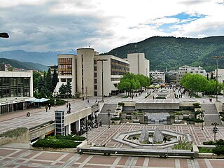
Blagoevgrad is а town in Southwestern Bulgaria, the administrative centre of Blagoevgrad Municipality and of Blagoevgrad Province. With a population of almost 70,000 inhabitants, it is the economic and cultural centre of Southwestern Bulgaria. It is located in the valley of the Struma River at the foot of the Rila Mountains, 101 kilometres south of Sofia, close to the border with North Macedonia.

Gabrovo is a city in central northern Bulgaria, the administrative centre of Gabrovo Province.
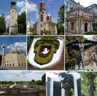
Razgrad is a city in Northeastern Bulgaria in the valley of the Beli Lom river that falls within the historical and geographical region of Ludogorie (Deliorman). It is an administrative center of Razgrad Province.

Targovishte is a city in Bulgaria, the administrative and economic capital of Targovishte Province.

Elhovo is a Bulgarian town in Yambol Province, located on the left bank of the Tundzha river, between Strandzha and Sakar mountains. Second largest city in the region after Jambol, the city is located at 36 km from border checkpoint Lesovo – Hamzabeyli on the Bulgarian – Turkish border. Elhovo is the administrative center of Elhovo municipality, which includes 21 villages (municipalities). The city's population as of 15 March 2023, was 9422 inhabitants.
Popovo is a town in northeastern Bulgaria, part of Targovishte Province. It is the administrative centre of the homonymous Popovo Municipality. In 2021, it had a population of 13,324 and an absolute Bulgarian majority.

Dospat is a town in the very south of Bulgaria, part of Smolyan Province, situated in the Rhodope Mountains, close to Dospat Dam. It is the administrative centre of the homonymous Dospat Municipality. As of December 2010, the town had a population of 2,425 who are mainly Bulgarian Muslims.
Obidim is a village (село) in southwestern Bulgaria, located in the Bansko Municipality of the Blagoevgrad Province in Pirin mountain 15 kilometers southeast of Bansko and 52 km southeast of Blagoevgrad.

Kribul is a village in Southwestern Bulgaria. It is located in the Satovcha Municipality, Blagoevgrad Province.
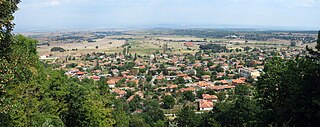
Mezek is a village in southeastern Bulgaria, part of Svilengrad municipality, Haskovo Province. It lies at the foot of the eastern Rhodope Mountains, just north of the Bulgaria–Greece border and not far west of the Bulgaria–Turkey border. Mezek is famous for the well-preserved medieval Mezek Fortress and its two ancient Thracian beehive tombs, the Mezek and Sheynovets tombs. The village is also well known for its own winery and the Mezzek brand of Bulgarian wine.
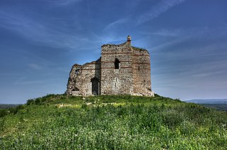
Matochina is a small village in southeastern Bulgaria, part of Svilengrad municipality, Haskovo Province. Matochina lies in the southernmost ridges of the Sakar Mountain, 40 kilometres (25 mi) from the municipal centre Svilengrad and 110 kilometres (68 mi) from the provincial capital Haskovo; it is located just west of the Bulgaria–Turkey border and not far northeast of the Bulgaria–Greece border. The village is famous for the medieval Matochina Fortress.
Izgrev is a village in Blagoevgrad Municipality, in Blagoevgrad Province, Bulgaria. It is situated in the foothills of Rila mountain 1 kilometer southeast of Blagoevgrad. The village was created in 1963 and named Aidarovo. The name was changed to Izgrev in 1987.
Lisiya is an almost abandoned village in Blagoevgrad Municipality, in Blagoevgrad Province, Bulgaria. It is situated in the foothills of Vlahina mountain. On January 29, 1944, thirteen Bulgarian Partizans died in a battle near the village. Lisiya Ridge on Graham Land, Antarctica is named after the village.

Marinka is a village in Burgas Municipality, in Burgas Province, in southeastern Bulgaria.
Cugnot Ice Piedmont is an ice piedmont in Trinity Peninsula, Antarctica. It is about 15 nautical miles long and between 3 and 6 nautical miles wide, extending from Russell East Glacier to Eyrie Bay and bounded on the landward side by Louis Philippe Plateau.
Zaldapa was a large Late Roman fortified city in Scythia Minor/Moesia, located near today's Abrit, Bulgaria.
Breze is a village in Svoge Municipality, Sofia Province, western Bulgaria.
Ezerets is a village in Kresna Municipality, Blagoevgrad Province, Bulgaria.
