The Absheron Economic Region is located in the eastern part of the Republic of Azerbaijan and comprises Baku and Sumgait cities and the Absheron and Khizi districts. The eastern part of the economic region is located on the shores of the Caspian Sea, which has positive effects on the economy of the region. It borders Shaki-Zaqatala economic region to the north, Mountainous Shirvan to the west and Aran to the south.
Absheron Economic Region Abşeron iqtisadi rayonu | |
---|---|
Country | Azerbaijan |
Area | |
• Total | 3,290 km2 (1,270 sq mi) |
Population | |
• Total | 2.939.000 |
• Density | 489.2/km2 (1,267/sq mi) |
Absheron Economic Region covers an area of 3,290 square kilometers, constituting approximately 3.9% of the territory of Azerbaijan (excluding the city of Baku), and there are approximately 568,000 people as of the beginning of January 2018 (also excluding Baku). The population density was 103 people per square km of land area. [1]
Due to the oil and gas reserves of the region, Absheron Economic Region is mainly specialized in fossil fuel production and relevant areas such as petrochemistry and chemistry. [1] [2] As a significant part of the oil and gas industry is concentrated in the region, heavy industry, energetic, engineering industry, electrical engineering, and ferrous and non-ferrous metallurgy have become important branches of industry. Polymers, glass and construction materials are produced by construction enterprises within the economic region. The following table shows information about the share of industry in the economy of Absheron Economic region. According to the source, the share of the private sector in industrial production has increased significantly since 2013. [3] [4] [5]
Statistic indicators for the industry by year. [3] | ||||||
2010 | 2012 | 2013 | 2014 | 2015 | 2016 | |
Number of operating enterprises total, unit | 256 | 213 | 218 | 235 | 253 | 236 |
Industrial product (actual price of the relevant year), thousand manat | 298,6 | 512,8 | 501,0 | 543,8 | 604,8 | 977,3 |
Industrial product, relative to previous year, in percent (at comparable prices) | 127,5 | 112,7 | 99,1 | 108,2 | 104,5 | 115,9 |
Share of the non-public sector in industrial product, in percent | 36,9 | 52,4 | 44,2 | 40,4 | 48,6 | 61,4 |
Remaining balance of finished goods for the year, thousand manat | 12944 | 55765 | 30226 | 27202 | 31554 | 33913 |
Average number of employees - total, people | 18378 | 17241 | 20899 | 21985 | 21834 | 19754 |
Average monthly salary of employees, manat | 293,0 | 370,9 | 448,8 | 489,5 | 494,3 | 493,9 |
Availability of the main industrial and production assets (at the end of the year with the balance sheet), million. manat | 1448 | 1622 | 1720 | 1794 | 1975 | 1979 |
The agriculture of Absheron Economic region consists of livestock (including dairy and beef animal breeding), sheep, poultry farming, horticulture, vegetables, viniculture (vine-growing) and dry subtropical fruits. Semi-desert and dry steppe climate conditions make it possible to grow olive, pistachio, almond and saffron. “Ag shany” and “Qara shany” is considered as indigenous to this region and covers the most part of the gardens. The table below shows the exact amount of agricultural production based on the statistics from 2010 to 2016. [1] [2] [6] [4]
Statistic data based on agricultural production. [6] | ||||||
2010 | 2012 | 2013 | 2014 | 2015 | 2016 | |
Total area of sown agricultural crops (ha) | ||||||
Cereals and cereal legumes | 1944 | 2425 | 2498 | 1842 | 1774 | 2691 |
Including wheat | 621 | 805 | 744 | 559 | 664 | 756 |
Sunflower for seed production | - | - | - | - | - | 10 |
Potato | 46 | 32 | 45 | 48 | 50 | 63 |
Vegetables | 474 | 468 | 482 | 493 | 564 | 792 |
Horticulture | 170 | 216 | 191 | 198 | 224 | 232 |
Fruit and berry | 2717 | 2753 | 2786 | 2782 | 2782 | 3191 |
Grape | 188 | 203 | 188 | 191 | 191 | 168 |
Productivity (in all categories of farming), ton | ||||||
Cereals and cereal legumes | 2809 | 3658 | 3750 | 2532 | 2650 | 4478 |
Including wheat | 938 | 1287 | 1198 | 863 | 1044 | 1369 |
Sunflower for seed production | - | - | - | - | - | 15 |
Potato | 320 | 217 | 320 | 335 | 352 | 461 |
Vegetables | 7865 | 7459 | 8420 | 9316 | 9402 | 45061 |
Horticulture | 1435 | 1692 | 1659 | 1720 | 2099 | 2361 |
Fruit and berry | 1808 | 1512 | 1633 | 1398 | 1683 | 1899 |
Grape | 209 | 223 | 230 | 257 | 506 | 516 |
Productivity (in all categories of farming), centner / ha | ||||||
Cereals and cereal legumes | 14,4 | 15,1 | 15,0 | 13,7 | 14,9 | 16,7 |
Including wheat | 15,1 | 16,0 | 16,1 | 15,4 | 15,7 | 18,1 |
Sunflower for seed production | - | - | - | - | - | 18,0 |
Potato | 70 | 68 | 72 | 70 | 71 | 73 |
Vegetables | 98 | 95 | 88 | 89 | 92 | 91 |
Horticulture | 84 | 78 | 87 | 87 | 94 | 102 |
Fruit and berry | 7,0 | 6,1 | 6,3 | 5,1 | 6,1 | 6,7 |
Grape | 17,9 | 7,3 | 7,5 | 8,7 | 20,8 | 22,8 |
Number of Livestock (in total) | ||||||
Cattle | 31457 | 33578 | 32508 | 32594 | 35042 | 35035 |
Including cow and buffalo | 17799 | 19206 | 18562 | 19185 | 19382 | 19623 |
Sheep and goats | 196088 | 211663 | 205700 | 204108 | 194867 | 193114 |
Pigs | 292 | - | 108 | 115 | 566 | - |
Birds | 3010234 | 2007630 | 1879475 | 3297755 | 2613531 | 3513874 |
Bee families | 849 | 980 | 850 | 1080 | 1051 | 1155 |
Production of animal products, ton | ||||||
Meat | 2543 | 4258 | 6230 | 7076 | 5149 | 5192 |
Milk | 42678 | 53580 | 53918 | 52802 | 56062 | 61280 |
Eggs | 333805 | 210700 | 173797 | 244074 | 254151 | 342826 |
Wool | 418 | 426 | 424 | 431 | 440 | 525 |
As the most important railways, highways and rivers pass through its territory, the infrastructure has developed more in the region compared to the rest of the country. Its access to the Caspian Sea enables maritime transportation. The table below indicates detailed data about transportation of both cargos and passengers. [7]
Statistics of Transportation by year. [7] | ||||||
2010 | 2012 | 2013 | 2014 | 2015 | 2016 | |
Cargo transportation, thousand tons | 3818 | 4431 | 4695 | 4822 | 5058 | 5240 |
Freight turnover, mlyn. tons | 329,9 | 405,2 | 433,0 | 445,5 | 467,8 | 484,3 |
Passenger transportation, thousand people | 94694 | 109777 | 117712 | 123777 | 131767 | 137273 |
Passenger turnover, mlyn. Passenger km | 1462,4 | 1653,3 | 1759,7 | 1851,0 | 1973 | 2057,8 |
Total number of cars, units | 33405 | 42911 | 51479 | 57548 | 60430 | 62421 |
including: | ||||||
Trucks | 4552 | 5589 | 6044 | 6527 | 6647 | 6781 |
Buses | 1970 | 1834 | 1901 | 1950 | 2038 | 2089 |
Number of vehicles for public transportation | 26097 | 34945 | 42861 | 48264 | 50881 | 52631 |
Personal cars | 25281 | 33958 | 41803 | 46997 | 49642 | 51427 |
Vehicles for special purposes | 595 | 373 | 447 | 449 | 477 | 522 |
Other vehicles | 191 | 170 | 226 | 358 | 387 | 398 |
The table below provides information on demography of Absheron Economic region from 2010 to 2016. There were 563,100 people in the economic region according to the statistics of 2016 (without the city of Baku). [8]
Demographic indicators of Absheron Economic Region. [8] | ||||||
2010 | 2012 | 2013 | 2014 | 2015 | 2016 | |
Population | ||||||
Population (by the end of the year, thousand people | 522,8 | 538,4 | 545,3 | 551,8 | 557,8 | 563,1 |
Natural increase | 4654 | 7706 | 5630 | 5949 | 5903 | 5403 |
Births | 7228 | 10341 | 8114 | 8610 | 8593 | 8222 |
Deaths | 2574 | 2635 | 2484 | 2661 | 2690 | 2819 |
Including: | ||||||
Children under the age of 1 | 132 | 148 | 142 | 126 | 174 | 128 |
Weddings | 3951 | 3888 | 4539 | 4595 | 3839 | 3699 |
Divorces | 595 | 811 | 854 | 777 | 820 | 871 |
Per 1000 population | ||||||
Natural increase | 9,0 | 14,5 | 10,4 | 10,8 | 10,7 | 9,7 |
Births | 13,9 | 19,4 | 15,0 | 15,7 | 15,5 | 14,7 |
Deaths | 4,9 | 4,9 | 4,6 | 4,9 | 4,8 | 5,0 |
Including: | ||||||
Children under the age 1 | 16,9 | 16,2 | 15,7 | 16,0 | 17,4 | 18,0 |
Weddings | 7,6 | 7,3 | 8,4 | 8,4 | 6,9 | 6,6 |
Divorces | 1,1 | 1,5 | 1,6 | 1,4 | 1,5 | 1,6 |
The territory of Absheron region covers the south-east parts of Lengebiz low-altitude mountain and The Greater Caucasus ranges, the east part of Gobustan and Absheron peninsula, south-east of Samur-Devechi lowland, and the northern part of the Southeastern Shirvan plain. The relief mainly consists of low-altitude mountains and plains. The surface is surrounded by crevices, crevices, gorges, hills, and slopes along the arches and tulips. Its lowest point is 28 m below sea level and the highest elevation is Dubrar Mountain (2205m above sea level). [1]
The river network of the region is sparse. The main rivers are Atacay, Sumgayit, Jeyrankechmez. The Samur-Absheron Channal and the Shirvan collector pass through its territory. There are numerous small lakes and the largest one is Masazir Lake. The salinity of the water of these lakes is very high. [9]
Azerbaijan is a country in the Caucasus region, situated at the juncture of Europe and Western Asia. Three physical features dominate Azerbaijan: the Caspian Sea, whose shoreline forms a natural boundary to the east; the Greater Caucasus mountain range to the north; and the extensive flatlands at the country's center. About the size of Portugal or the US state of Maine, Azerbaijan has a total land area of approximately 86,600 square kilometers, less than 1% of the land area of the former Soviet Union. Of the three Transcaucasian states, Azerbaijan has the greatest land area. Special administrative subdivisions are the Nakhchivan Autonomous Republic, which is separated from the rest of Azerbaijan by a strip of Armenian territory, and the Nagorno-Karabakh Autonomous Region, entirely within Azerbaijan. The status of Nagorno-Karabakh is disputed by Armenia.
Siyazan District is one of the 66 districts of Azerbaijan. It is located in the north-east of the country and belongs to the Quba-Khachmaz Economic Region. The district borders the districts of Shabran, Khizi, and the exclaves of Quba. Its capital and largest city is Siyazan. As of 2020, the district had a population of 42,600.
Absheron District is one of the 66 districts of Azerbaijan. It is located in the east of the country and belongs to the Absheron Economic Region. The district borders the districts of Khizi, Gobustan, Baku, Hajigabul, Salyan, and the city of Sumgait. Its capital and largest city is Khirdalan. As of 2020, the district had a population of 214,100. Although the district shares the same name as the Absheron Peninsula, the area covered by the district is not conterminous, being further west and mostly inland.
Ujar District is one of the 66 districts of Azerbaijan. It is located in the centre of the country and belongs to the Aran Economic Region. The district borders the districts of Agdash, Goychay, Kurdamir, and Zardab. Its capital and largest city is Ujar. As of 2020, the district had a population of 89,500.
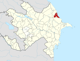
Shabran District is one of the 66 districts of Azerbaijan. It is located in the north-east of the country and belongs to the Quba-Khachmaz Economic Region. The district borders the districts of Khachmaz, Quba, Khizi and Siyazan. Its capital and largest city is Shabran. As of 2020, the district had a population of 59,900.
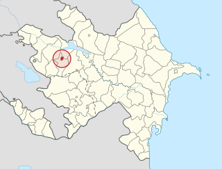
Goychay District is one of the 66 districts of Azerbaijan. It is located in the centre of the country and belongs to the Aran Economic Region. The district borders the districts of Agdash, Qabala, Ismayilli, Kurdamir, and Ujar. Its capital and largest city is Goychay. As of 2020, the district had a population of 121,700. It is famous for its pomegranate growing industry, and for its pomegranate festival.
Hajigabul District is one of the 66 districts of Azerbaijan. It is located in the east of the country and belongs to the Aran Economic Region. The district borders the districts of Kurdamir, Agsu, Shamakhi, Gobustan, Absheron, Baku, Salyan, Sabirabad and the city of Shirvan. Its capital and largest city is Hajigabul. As of 2020, the district had a population of 76,600.
Kurdamir is a city and the capital of the Kurdamir District of Azerbaijan. It is located in Aran Economic Region.
Fauna of Azerbaijan or animal kingdom of Azerbaijan refers to the diversity of various types of animals, which inhabit and populate a defined ground or water area in Azerbaijan.
The environment of Azerbaijan, includes a wide diversity of climates, animals, plants, and habitats.
Orography of Azerbaijan refers to the rocky, mountainous and elevated terrains in Azerbaijan. The tectonic structure is typical for the orography of the country. The main morphostructural units are the Greater Caucasus, the Lesser Caucasus, the Gusar plane, the Samur-Devechi lowland, the Kur intermountain trough, the Karabagh volcanic highland, the near and middle Araz Ridges and Talysh Mountains.
National Parks of Azerbaijan are run by the Ministry of Ecology and Natural Resources in the Republic of Azerbaijan. The first national park established was Zangezur National Park in 2003. Since then a further 9 national parks have been established; the most recent being the Gizilaghaj National Park in 2018.
The Absheron Peninsula is a peninsula in Azerbaijan. It is the location of Baku, the biggest and the most populous city of the country, and also the Baku metropolitan area, with its satellite cities Sumqayit and Khyrdalan.
The geology of Azerbaijan forms a constituent geological part of the Alpine fold belt. Sedimentary deposits embracing the southwestern parts of the Major and Minor Caucasus, including the intermountain Kur River trough, as well as the Mid- and South Caspian basins consist of diversity fold systems. The Earth's crust thickness in Azerbaijan varies in the range from 38 to 55 km. Its maximum thickness is observed in the Minor Caucasus area, while its minimum thickness is typical for the Talysh foothills. The geological setting of the area consists of sedimentary, volcanic-sedimentary, volcanic and terrestrial deposits embracing almost the entire stratigraphic range beginning from Pre-Cambrian through Holocene time.
Samur–Absheron channel is an irrigation channel in Azerbaijan flowing from Russia-Azerbaijan border to the Jeyranbatan reservoir.
The Azerbaijan is a country with very favorable natural conditions and rich natural resources. Snowy peaks, high mountains, foothill fertile soils, wide plains, Lowest Land Points Below Ocean Level are the main landscape forms of republic. This complex landscape structure has caused the variety in natural conditions - climate, soil-vegetation, and water resources. This, in turn, led to the uneven distribution of population and farms on the territory, and the specialization of production on different types.
Ganja is the second largest city of Azerbaijan, according to its population (331.4 thousand, however, it is behind Baku and Sumqayit in terms of industrial production. The city is located in Ganja-Gazakh economic region. The economy of Ganja embraces the issues connected to the economy of the city of Ganja. Industry, tourism, agriculture, and transportation are the major branches of its economy. Most of the total volume of industrial products is accounted for non-ferrous metallurgy, light and food industries, electronics industry and home appliances.
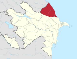
The Guba-Khachmaz economic region is situated in the north-east of Azerbaijan, to the north of the Absheron Peninsula, between the shores of the Caspian Sea and the Greater Caucasus mountains. It makes up the European part of the country.
Lankaran–Astara Economic Region is one of the 10 economic regions of Azerbaijan. It borders Iran to the south and west, Caspian sea to the east, and Aran economic region to the north. Region consists of Astara, Jalilabad, Lerik, Lankaran, Masally and Yardimli administrative districts. Other than the 6 districts, there are 8 cities, 13 settlements, 642 villages and 182 municipalities in the economic region. Each administrative district is headed by a chief executive appointed by the president of Azerbaijan. Heads of district executive powers are responsible for the establishment of representative offices of the executive power in the respective villages and settlements situated in their respective territories and appoint their representatives. Municipalities are divided into administrative-territorial units in districts and towns divided by settlements.
Aran economic region is one of the 10 economic regions of Azerbaijan. It borders Iran to the south, as well as the economic regions of Upper Karabakh, Ganja-Gazakh, Shaki-Zagatala, Mountainous Shirvan, Absheron, and Lankaran. The region consists of the districts of Agdash, Aghjabadi, Barda, Beylagan, Bilasuvar, Jalilabad, Goychay, Hajigabul, Imishli, Kurdamir, Neftchala, Saatly, Sabirabad, Salyan, Ujar, Yevlakh, Zardab and the cities of Mingachevir, Shirvan and Yevlakh.
This article needs to be updated.(December 2021) |