This article includes information about Camster Loch and Allt Beag-airighe
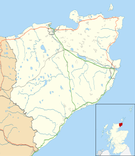
Achairn Burn, known also as Haster Burn, is one of the major tributaries of Wick River, in Caithness, in the Highland area of Scotland. The burn's source is in headwaters flowing from the northern slope of the Hill of Toftgunn, which rises to over 170 metres, and in Camster Loch, which is at nearly 120 metres, between the Hill of Toftgunn and Ballharn Hill. The same area feeds also another major tributary of Wick River, the Camster/Rowans-Strath Burn. Achairn Burn enters Wick River at Mary Ford, about 10 kilometres to the northeast of the burn's source. Its entire course is within Caithness, as is the whole of the catchment basin of Wick River.

A tributary or affluent is a stream or river that flows into a larger stream or main stem river or a lake. A tributary does not flow directly into a sea or ocean. Tributaries and the main stem river drain the surrounding drainage basin of its surface water and groundwater, leading the water out into an ocean.

Wick River, known also as River Wick, is a river in Caithness in Highland, Scotland. It has its source at the confluence of Scouthal Burn and Strath Burn near Achingale Mill at the northern end of Bardarclay Moss in the Flow Country. The river estuary, is in the North Sea bay of Wick and is straddled by the town of Wick. The source is at a height of about 25 metres, about 11 kilometres west and 2 kilometres north of the estuary.

Caithness is a historic county, registration county and lieutenancy area of Scotland.
Between its source and Maryford the burn's course describes a sort of reversed S-shape, flowing generally north, then turning east and east/southeast before turning north again. On its banks the burn has Upper Achairn, Lower Achairn, Puldagon, and Haster. Between Upper Achairn and Lower Achairn the burn receives water from Allt Beag-airighe (Burn of the Small Shieling). In the Puldagon area it is bridged by a small, single-track road linking the A882 road, near the Bridge of Haster, with the A99 road in the Thrumster area. The Bridge of Haster carries the A882 itself, about 3 kilometres west of Wick and about one kilometre south of Maryford.
Haster is a small remote rural hamlet and district in Wick, in the Highland area of Scotland. It is located just west of the Bridge of Haster, which carries the A882 road linking the burghs of Wick and Thurso over Achairn Burn to the main A9 road. It is about four kilometres west of Wick and about eight kilometres east of Watten. An older centre is about one kilometre to the south.

A road is a thoroughfare, route, or way on land between two places that has been paved or otherwise improved to allow travel by foot or some form of conveyance, including a motor vehicle, cart, bicycle, or horse.
The A882 road is entirely within Caithness in the Highland area of Scotland. It has a length of about 23 kilometres (14 mi) and runs generally west/northwest from the A99 in the county town of Wick to the A9 in the Georgemas area.
This page is based on this
Wikipedia article Text is available under the
CC BY-SA 4.0 license; additional terms may apply.
Images, videos and audio are available under their respective licenses.
The River Spey is a river in the northeast of Scotland. It is the ninth longest river in the United Kingdom, as well as the third longest and fastest-flowing river in Scotland. It is important for salmon fishing and whisky production.
Loch Burn is a stream that flows out of the eastern end of Loch Watten in Caithness, in the Highland area of Scotland, at a height of around 20 metres and about one kilometre north/northeast of the village of Watten. Less than a kilometre east of its source at Loch Watten the burn flows into Wick River.

The River Thurso has Loch Rumsdale in Caithness as its source, about 26 kilometres south and 14 kilometres west of the burgh of Thurso, Caithness, and about 2 kilometres south of the railway line linking the burghs of Thurso and Wick with Inverness. At its source and until it reaches Loch More the river is known also as Strathmore Water. Caithness is in the Highland area of Scotland.
Forss Water, known also as Forss River, has its source at the northern end of Loch Shurrey, at grid reference ND042568. About 13 kilometres north of its source the river flows into Crosskirk Bay and the Atlantic Ocean at ND029700. Crosskirk Bay is on the north coast of Great Britain and about 8 kilometres west of the burgh of Thurso, Caithness, in Highland, Scotland.
The river marked the eastern extent of the Clan Mackay raid in the Sandside Chase of 1437.
Watten is a small village in Caithness, in the Highland area of Scotland, on the main road (A882-A9) between the burgh of Wick and the town of Thurso, about twelve kilometres west of Wick and close to Wick River and to Loch Watten. The village is on The Far North railway line but trains stopped calling at the village in 1960. The railway station is now a private house.

Morrone is a Scottish hill immediately southwest of the village of Braemar in Aberdeenshire.

Gairich is a mountain in Scotland situated on the southern side of Loch Quoich between Glen Kingie and Glen Garry in the Lochaber district of the Highland Council Area, 25 kilometres north-northwest of Fort William.
Upper Camster is a small hamlet, which lies at the source of the Camster Burn, 4 miles north of Lybster, in Caithness, Scottish Highlands and is in the Scottish council area of Highland.

The River Helmsdale is one of the major east-flowing rivers of Sutherland in the Highlands of Scotland. It flows broadly southeastwards from Loch Badanloch down the Strath of Kildonan, gathering the waters of the Bannock Burn on its left and the Abhainn na Frithe on its right before discharging into the Moray Firth on the North Sea at the town of Helmsdale. Other significant tributaries of the Helmsdale include the left-bank Suisgill Burn and the right-bank Craggie Water. Loch Achnamoine which is just over 1 km in length, lies on the line of the river 1 mi / 1.5 km downstream of Loch Badanloch. Loch Badanloch is one of a complex of three interconnecting lochs - the other two being Loch nan Clàr and Loch Rimsdale which gather waters from the moors on the southern edge of the Flow Country via the Allt an Lòin Tharsuinn, Allt Lòn a' Chùil and Rimsdale Burn.

The River Nairn is a river in the Scottish Highlands which rises in the Monadhliath Mountains and flows northeast through Strathnairn to enter the Moray Firth at Nairn. The headwaters of the Nairn, the Allt Mor and Crom-allt Beag drop steeply down the western slopes of Càrn Ghriogair, their combined waters flowing beneath the B851 road and turning northeastwards. The young River Nairn is soon joined by the diminutive River Brin on the right bank and later by a burn draining the sizeable Loch Duntelchaig on the left. The River Farnack is the next right bank tributary, followed by the Craggie Burn near the A9 road crossing of the Nairn at Daviot.

The Luggie Water is one of two streams which flow out of Cumbernauld. The Scottish New Town’s name derives from the Gaelic for "the meeting of the waters" and it’s possible this refers to the Luggie Water and the Red Burn, both of which run through Cumbernauld but which never meet.
