Related Research Articles

Salisbury Plain is a chalk plateau in southern England covering 300 square miles (780 km2). It is part of a system of chalk downlands throughout eastern and southern England formed by the rocks of the Chalk Group and largely lies within the county of Wiltshire, but stretches into Hampshire.
Briarcroft Pasture is a 1.76 hectare biological Site of Special Scientific Interest in County Durham, England notified in 2004.
Whitton Bridge Pasture is a Site of Special Scientific Interest (SSSI) in the unitary authority of Stockton-on-Tees, England. At 3.18 hectares (7.9 acres) it lies to the south of Whitton village and north west of Stockton-on-Tees. SSSIs are chosen by Natural England, and Whitton Bridge Pasture was designated in 2004 because of its biological interest. It is one of 18 SSSIs in the Cleveland area of search.
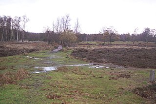
Hothfield Common is a 56.5-hectare (140-acre) biological Site of Special Scientific Interest north-east of Ashford in Kent. It is also a Local Nature Reserve, and is part of the 86-hectare (210-acre) Hothfield Heathlands nature reserve owned by Ashford Borough Council and managed by Kent Wildlife Trust.
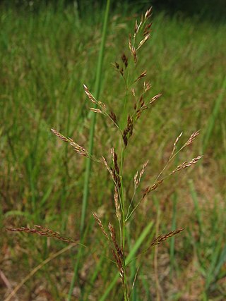
Agrostis capillaris, the common bent, colonial bent, or browntop, is a rhizomatous and stoloniferous perennial in the grass family (Poaceae). It is native to Eurasia and has been widely introduced in many parts of the world. Colonial bent grows in moist grasslands and open meadows, and can also be found in agricultural areas, roadsides, and invading disturbed areas.
Lowland heath is a Biodiversity Action Plan habitat as it is a type of ancient wild landscape. Natural England's Environmental Stewardship scheme describes lowland heath as containing dry heath, wet heath and valley mire communities, usually below 250 metres (820 ft) in altitude, on acidic soils and shallow peat, typically comprising heathers, gorses, fine grasses, wild flowers and lichens in a complex mosaic. Heathers and other dwarf shrubs usually account for at least 25% of the ground cover. By contrast, upland heath, which is above 300 metres (980 ft) in altitude, is called moorland, Dartmoor being an example.

Agrostis gigantea, known by its common names black bent and redtop, is a perennial grass of the Agrostis genus.

Purple moor grass and rush pastures is a type of Biodiversity Action Plan habitat in the UK. It occurs on poorly drained neutral and acidic soils of the lowlands and upland fringe. It is found in the South West of England, especially in Devon.
Chalk heath is a rare habitat, in the temperate grasslands, savannas, and shrublands biome, formed of a paradoxical mixture of shallow-rooted calcifuge ("calcium-hating") and deeper-rooted calcicole ("calcium-loving") plants, growing on a thin layer of acidic soil over an alkaline substrate. Chalk heath is intermediate between two much more widespread habitats, chalk grassland and heathland.

Gunnersbury Triangle is a 2.57-hectare (6.4-acre) local nature reserve in Chiswick, in the London boroughs of Ealing and Hounslow, immediately to the east of Gunnersbury. It was created in 1983 when, for the first time in Britain, a public inquiry ruled that a planned development of the land could not go ahead because of its value for nature. It opened as a nature reserve in 1985.

Agrostis canina, the velvety bentgrass, brown bent or velvet bent, is a species of grass in the family Poaceae.

Polruan to Polperro is a coastal Site of Special Scientific Interest (SSSI) and Special Area of Conservation (SAC) in south-east Cornwall, England, UK, noted for its biological interest. It contains a wide variety of plant species and is a site for populations of breeding birds.

Wangford Warren and Carr is a 67.8-hectare (168-acre) biological Site of Special Scientific Interest between Brandon and Lakenheath in Suffolk. It is a Nature Conservation Review site, Grade I, and part of the Breckland Special Area of Conservation, and Special Protection Area An area of 15 hectares is managed as a nature reserve by the Suffolk Wildlife Trust
Poor's Allotment is a 28.57-hectare (70.6-acre) biological Site of Special Scientific Interest in Gloucestershire, notified in 1954. The site is listed in the 'Forest of Dean Local Plan Review' as a Key Wildlife Site (KWS).
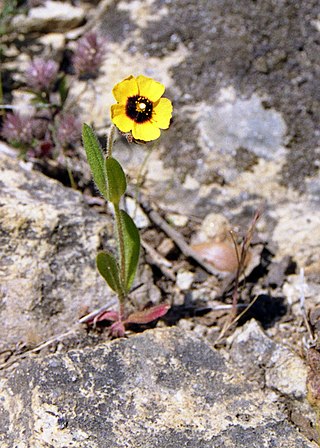
Clegir Mawr is a Site of Special Scientific Interest (SSSI) in the community of Cylch-y-Garn in the north-west of the island of Anglesey, Wales. It is a stony coastal headland with an area just under 10 hectares and has been designated principally because of the occurrence of the spotted rock-rose which is a nationally rare plant and also the county flower of Anglesey.

North Devon's Biosphere Reserve is a UNESCO biosphere reserve in North Devon. It covers 55 square miles (140 km2) and is centred on Braunton Burrows, the largest sand dune system (psammosere) in England. The boundaries of the reserve follow the edges of the conjoined catchment basin of the Rivers Taw and the Torridge and stretch out to sea to include the island of Lundy. The biosphere reserve is primarily lowland farmland, and includes many protected sites including 63 Sites of Special Scientific Interest which protect habitats such as culm grassland and broadleaved woodlands. The most populous settlements in its buffer area are Barnstaple, Bideford, Northam, Ilfracombe, and Okehampton.
Monawilkin is a townland in the West Fermanagh Scarplands in the Civil Parish of Inishmacsaint, Barony of Magheraboy, Northern Ireland. The townland has an area of 85.1947 hectares and has previously been referred to as Meenwilkin (1817) and Munadh Wilkin. Monawilkin is the best example of unimproved calcareous grassland in Northern Ireland. This differs from other Sesleria-dominated grasslands in the UK in that it also includes species such as Euphrasia salisburgensis (eyebright). Monawilikin is also an important orchid site, contains the best inland site for moths and butterflies in Northern Ireland, and is the only Northern Irish site for Cupido minimus, the small blue butterfly. Consequently, this area was designated as a special area of conservation (SAC) and area of special scientific interest (ASSI). The Monawilkin SAC land cover comprises 3% water bodies, 5% bogs, marshes, and fringe water vegetation, 13% heath and scrub, 50% dry grassland, 14% humid grassland, and 15% broad-leaved woodland.
Gweunydd Glan-y-glasnant is a Site of Special Scientific Interest (SSSI) in Carmarthenshire, Wales, designated in 1993 for its botanical features.
Allolee to Walltown is the name given to a Site of Special Scientific Interest (SSSI) in Northumberland, England. The site, which follows the path of a section of Hadrian's Wall, is notable for an unusually wide range of grassland types growing on thin soil above the Whin Sill, a rock formation peculiar to the Northern Pennines.

Snape Warren is a 48 hectare biological Site of Special Scientific Interest east of Snape in Suffolk. It is part of the Sandlings Special Protection Area under the European Union Directive on the Conservation of Wild Birds, and in the Suffolk Coast and Heaths Area of Outstanding Natural Beauty.
References
- ↑ "Acid grasslands - lowland". Joint Nature Conservation Committee. Retrieved 30 March 2015.
- ↑ "Lowland Dry Acid Grassland". The Wildlife Trusts. Archived from the original on 11 August 2016. Retrieved 30 March 2015.
- ↑ "Acid Grassland: a nationally important habitat in London" (PDF). London Biodiversity Partnership. Archived from the original (PDF) on 3 April 2015. Retrieved 30 March 2015.