
Koewacht is a village on the border between the Netherlands and Belgium.
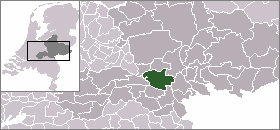
Pijnacker is a town in the Dutch province of South Holland. It is located about 4 km east of the city of Delft, in the municipality of Pijnacker-Nootdorp.

Nootdorp is a town in the Dutch province of South Holland. It is located approximately 2 km to the east of Delft and about 6 km southeast of the centre of The Hague. Nootdorp was a separate municipality until 2002, when it merged with Pijnacker to form Pijnacker-Nootdorp.
Everdingen is a former municipality in the Netherlands. Together with Zijderveld and Hagestein, it had been part of Vianen municipality since 1986. Since 2019 it is a part of the municipality Vijfheerenlanden. It enjoys a strategic position on the Lekdijk to the south of the river Lek. The eastern limits of Everdingen are marked by the Diefdijk, which also marks the municipal and provincial boundaries. Fort Everdingen was built nearby during the 19th century as a part of the Hollandse Waterlinie.

Ameide is a village in the Dutch province of Utrecht. It is a part of the municipality of Vijfheerenlanden, and lies about 9 km southwest of IJsselstein.

Lexmond is a town in the Dutch province of Utrecht. It is a part of the municipality of Vijfheerenlanden, and lies about 7 km south of IJsselstein.

Tienhoven is a village in the Dutch province of Utrecht. It is a part of the municipality of Vijfheerenlanden, and lies about 10 km southwest of IJsselstein.
Abtsregt is a former municipality in the Dutch province of South Holland. It was located about 4 km southeast of Delft. The municipality existed from 1817 to 1855, when it merged with Vrijenban. It had around 200 inhabitants at that time.

Cadzand is a town in the Dutch province of Zeeland. It is located in the municipality of Sluis, about 8 km northwest of Oostburg. The village contains 790 inhabitants (2010). Better known to many visitors is the nearby beach at Cadzand-Bad.
Capelle en Botland is a short-lived municipality in the Dutch province of Zeeland. It existed until 1813, when it was annexed by the municipality of Nieuwerkerk.
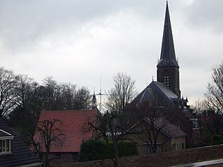
Heteren is a village in the Dutch province of Gelderland. It is located in the municipality of Overbetuwe, about 12 km southwest of Arnhem on the south bank of the Rhine. Heteren was a separate municipality until 2001, when it became a part of the new municipality of Overbetuwe. Heteren is home to the main distribution centre of leading Dutch pharmacy chain 'Kruidvat'.

Groeneveld is a former municipality in the Dutch province of South Holland. It was located to the west of the city of Delft. The municipality covered the Groeneveldse Polder, northwest of De Lier, and contained no towns or villages; only the hamlet of Lierhand.

Hodenpijl is a hamlet in the Dutch province of South Holland. It is located 3 km southwest of the centre of Delft, in the municipality of Midden-Delfland.
Hoog en Woud Harnasch is a former municipality in the Dutch province of South Holland. It was located to the west of the city of Delft.
Ruiven is a former municipality in the Dutch province of South Holland. It was located about 4 km southeast of the city of Delft.

Schiebroek is a former village in the Dutch province of South Holland. It is now a neighbourhood of Rotterdam, and part of the borough of Hillegersberg-Schiebroek.
Vrijenban is a neighborhood of Delft in the Netherlands province of South Holland. It is located on the northeast boundary of the historic city center of Delft. Prior to being merged into Delft, Vrijenban used to be a municipality in its own right.

't Woudt is a small village in the Dutch province of South Holland. It is located about 5 km southwest of the city of Delft, in the municipality of Midden-Delfland.
Zuidwijk is a former municipality in the Dutch province of South Holland. It was located southeast of the center of Boskoop.

Zweth or De Zweth is a hamlet in the western Netherlands. It is located about halfway between Delft and Rotterdam, where the small river Berkelsche Zweth joins the Schie river, around a bridge across the Berkelsche Zweth.


