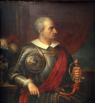
Diego de Almagro, also known as El Adelantado and El Viejo, was a Spanish conquistador known for his exploits in western South America. He participated with Francisco Pizarro in the Spanish conquest of Peru. While subduing the Inca Empire he laid the foundation for Quito and Trujillo as Spanish cities in present-day Ecuador and Peru respectively. From Peru, Almagro led the first Spanish military expedition to central Chile. Back in Peru, a longstanding conflict with Pizarro over the control of the former Inca capital of Cuzco erupted into a civil war between the two bands of conquistadores. In the battle of Las Salinas in 1538, Almagro was defeated by the Pizarro brothers and months later he was executed.

The history of Panama includes the history of the Isthmus of Panama prior to European colonization.
Diego de Nicuesa was a Spanish conquistador and explorer.
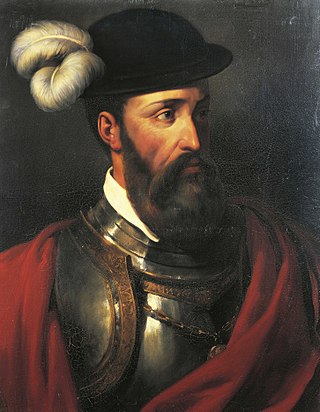
Francisco Pizarro, Marquess of the Atabillos was a Spanish conquistador, best known for his expeditions that led to the Spanish conquest of the Inca Empire.

Guna Yala, formerly known as San Blas, is a comarca indígena in northeast Panama. Guna Yala is home to the indigenous people known as the Gunas. Its capital is Gaigirgordub. It is bounded on the north by the Caribbean Sea, on the south by the Darién Province and Emberá-Wounaan, on the east by Colombia, and on the west by the province of Colón.

Darién is a province in Panama whose capital city is La Palma. With an area of 11,896.5 km2 (4,593.3 sq mi), it is located at the eastern end of the country and bordered to the north by the province of Panamá and the region of Kuna Yala. To the south, it is bordered by the Pacific Ocean and Colombia. To the east, it borders Colombia; to the west, it borders the Pacific Ocean and the province of Panama.

Santa María la Antigua del Darién—turned into Dariena in the Latin of De Orbo Novo—was a Spanish colonial town founded in 1510 by Vasco Núñez de Balboa, located in present-day Colombia approximately 40 miles (64 km) south of Acandí, within the municipality of Unguía in the Chocó Department. It was the first city founded by conquistadors in mainland America. After Pascual de Andagoya, a Spanish-Basque conquistador under the direction of Panama governor Pedrarias Dávila, founded Panama City in 1519, Santa María la Antigua del Darién was abandoned and in 1524 was attacked and burned by the indigenous people.

Pedro Arias de Ávila was a Spanish soldier and colonial administrator. He led the first great Spanish expedition to the mainland of the New World. There, he served as governor of Panama (1514–1526) and Nicaragua (1527–1531), and founded Panama City (1519). He died in 1531 aged around 90 or 91.
The Isthmus of Panama, also historically known as the Isthmus of Darien, is the narrow strip of land that lies between the Caribbean Sea and the Pacific Ocean, linking North and South America. It contains the country of Panama and the Panama Canal. Like many isthmuses, it is a location of great geopolitical and strategic importance.

Rodrigo de Bastidas was a Spanish conquistador and explorer who mapped the northern coast of South America, discovered Panama, and founded the city of Santa Marta.

Vasco Núñez de Balboa was a Spanish explorer, governor, and conquistador. He is best known for crossing the Isthmus of Panama to the Pacific Ocean in 1513, becoming the first European to lead an expedition to have seen or reached the Pacific from the New World.
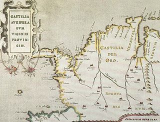
Castilla de Oro or del Oro was the name given by the Spanish settlers at the beginning of the 16th century to the Central American territories from the Gulf of Urabá, near today's Colombian-Panamanian border, to the Belén River. Beyond that river, the region was known as Veragua, and was disputed by the Spanish crown along with the Columbus family. The name "Castilla de Oro" was made official in May 1513 by King Ferdinand II of Aragon, then regent of the Crown of Castile.

Francisco Xerez, Francisco de Jerez, or Francisco de Xerxes (1495–1565?) was a Spanish explorer-turned-historian, the personal secretary of conquistador Francisco Pizarro. He participated in the conquest of Peru during the first two unsuccessful expeditions led by Pizarro, Diego de Almagro and Hernando de Luque in 1524. Xerez did not stay and join The thirteen of the fame in the Isle of Gallo (1526).

Gil González Dávila or Gil González de Ávila was a Spanish conquistador and the first European to explore present-day Nicaragua.
Riosucio is a municipality and town in the Department of Chocó, Colombia. The municipality and town are located in the Atrato River basin, on the Chocoan side of Urabá, a region spanning the departments Chocó and Antioquia.
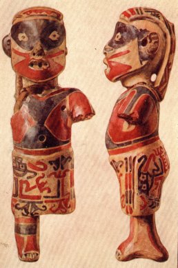
In the history of Panama, the earliest known inhabitants were the Cueva and Coclé tribes, but they were drastically reduced by disease and fighting when the Spanish arrived in the 16th century. But some moved out of Panama to have children and increase population.

Gaspar de Espinosa y Luna was a Spanish explorer, conquistador and politician. He participated in the expedition of Pedro Arias Dávila to Darién and was appointed mayor of Santa María la Antigua del Darién. He initiated proceedings against Vasco Núñez de Balboa and conquered part of current Costa Rica. After living some time in Spain, he returned to America to join Francisco Pizarro and Diego de Almagro in the conquest of the Inca Empire.

The Spanish conquest of Honduras was a 16th-century conflict during the Spanish colonization of the Americas in which the territory that now comprises the Republic of Honduras, one of the seven states of Central America, was incorporated into the Spanish Empire. In 1502, the territory was claimed for the king of Spain by Christopher Columbus on his fourth and final trip to the New World. The territory that now comprises Honduras was inhabited by a mix of indigenous peoples straddling a transitional cultural zone between Mesoamerica to the northwest, and the Intermediate Area to the southeast. Indigenous groups included Maya, Lenca, Pech, Miskitu, Mayangna (Sumu), Jicaque, Pipil and Chorotega. Two indigenous leaders are particularly notable for their resistance against the Spanish; the Maya leader Sicumba, and the Lenca ruler referred to as Lempira.
The Spanish conquest of Nicaragua was the campaign undertaken by the Spanish conquistadores against the natives of the territory now incorporated into the modern Central American republic of Nicaragua during the colonisation of the Americas. Before European contact in the early 16th century, Nicaragua was inhabited by a number of indigenous peoples. In the west, these included Mesoamerican groups such as the Chorotega, the Nicarao, and the Subtiaba. Other groups included the Matagalpa and the Tacacho.

Panama–Spain relations are the diplomatic relations between Panama and Spain. Both nations are members of the Association of Academies of the Spanish Language and the Organization of Ibero-American States.