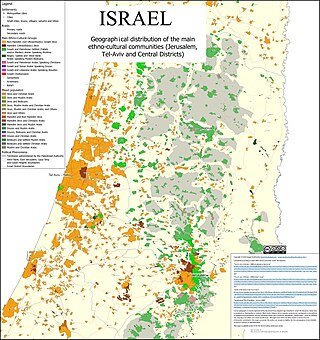
The demographics of Israel, monitored by the Israel Central Bureau of Statistics, encompass various attributes that define the nation's populace. Since its establishment in 1948, Israel has witnessed significant changes in its demographics. Formed as a homeland for the Jewish people, Israel has attracted Jewish immigrants from Europe, Asia, Africa, and the Americas.

The Northern District is one of Israel's six administrative districts. The Northern District has a land area of 3,324 km2, making it the second largest district in Israel. The district capital is Nof HaGalil and the largest city is Nazareth.

The Central District of Israel is one of six administrative districts, including most of the Sharon region. It is further divided into four sub-districts: Petah Tikva, Ramla, Sharon, and Rehovot. The district's largest city is Rishon LeZion. The district's population as of 2017 was 2,115,800. According to the Israeli Central Bureau of Statistics, 88% of the population is Jewish, 8.2% is Arab, and 4% are "non-classified", being mostly former Soviet Union immigrants of partial or nominal Jewish ethnic heritage or household members of Jews.

The Jerusalem District is one of the six administrative districts of Israel. The district capital is Jerusalem and its total land area is 652 km2. The population of 1,159,900 is 66.3% Jewish and 32.1% Arab. A fifth (21%) of the Arabs in Israel live in the Jerusalem Municipality, which includes both East and West Jerusalem. Israel's annexation of East Jerusalem has not been recognized by the international community.

There are six main administrative districts of Israel, known in Hebrew as mekhozot and in Arabic as mintaqah. There are also 15 subdistricts of Israel, known in Hebrew nafot and in Arabic as qadaa. Each subdistrict is further divided into natural regions, which in turn are further divided into council-level divisions: whether they might be cities, municipalities, or regional councils.

Demographic features of the population of the area commonly described as the Palestinian territories includes information on ethnicity, education level, health of the populace, economic status, religious affiliations and other aspects of that population.

Arab localities in Israel include all population centers with a 50% or higher Arab population in Israel. East Jerusalem and Golan Heights are not internationally recognized parts of Israel proper but have been included in this list.
The Safed subdistrict is one of Israel's sub-districts in the Northern District. As the name suggests, the main settlement is the town of Safed.
The Kinneret Subdistrict is one of the subdistricts of Israel's Northern District. The largest city and the centre of the subdistrict is the city of Tiberias on the western coast of the Sea of Galilee.
The Jezreel subdistrict is one of Israel's sub-districts in Northern District.
The Haifa Subdistrict is one of Israel's sub-districts in Haifa District. The Subdistrict is composed of mostly of the Northern half of the historical Mandatory Haifa Subdistrict.
The Hadera subdistrict is one of Israel's subdistricts in Haifa District. The district is composed of mostly of the Southern half of Mandatory Haifa Subdistrict.
The Golan Subdistrict is an area administered by Israel as a subdistrict of Northern District. The subdistrict encompasses the Israeli-occupied territories of the Golan Heights, occupied from Syria during the 1967 Six-Day War and annexed to Israel under the Golan Heights Law. Thus, this region is internationally seen as Syrian territory, encompassing parts of the Syrian Quneitra Governorate.
The HaSharon Subdistrict is one of Israel's subdistricts in the Central District. The principal city of this subdistrict is Netanya. The subdistrict is situated in the Sharon plain, a section of Israel's coastal plain, from which it draws its name.
The Petah Tikva Subdistrict is one of Israel's subdistricts in the Central District. The principal city of this subdistrict, as the name implies, is Petah Tikva.
The Rehovot subdistrict is one of Israel's subdistricts in Central District. The principal city of the subdistrict is, as the name implies, Rehovot.
The Ramla subdistrict is one of Israel's subdistricts in the Central District. There are three principal cities in the subdistrict: Ramla, Lod, and Modi'in-Maccabim-Re'ut.
The Ashkelon Subdistrict is the northern of the two sub-districts in Israel's Southern District. Its population is more than half a million. It is an important region for manufacturing including electricity production and water desalination, agriculture, transportation, tourism, and trade.
The Beersheba Subdistrict is the southernmost subdistrict of Israel and one of two subdistricts in its Southern District. The capital of the subdistrict is, as the name implies, Beersheba. Rahat is the second-largest city and Eilat comes third. Other cities in the subdistrict are Arad, Dimona, Netivot, and Ofakim. Hura and Kseifa have not received city status yet are of similar size. The subdistrict includes an international airport, near Eilat, and a seaport in Eilat.


