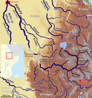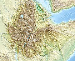
Lake Tana is the largest lake in Ethiopia and the source of the Blue Nile. Located in Amhara Region in the north-western Ethiopian Highlands, the lake is approximately 84 kilometres long and 66 kilometres wide, with a maximum depth of 15 metres, and an elevation of 1,788 metres. Lake Tana is fed by the Gilgel Abay, Reb and Gumara rivers. Its surface area ranges from 3,000 to 3,500 square kilometres, depending on season and rainfall. The lake level has been regulated since the construction of the control weir where the lake discharges into the Blue Nile. This controls the flow to the Blue Nile Falls and hydro-power station.

The Nile is a major north-flowing river in northeastern Africa. It flows into the Mediterranean Sea. The longest river in Africa, it has historically been considered the longest river in the world, though this has been contested by research suggesting that the Amazon River is slightly longer. The Nile is amongst the smallest of the major world rivers by measure of cubic metres flowing annually. About 6,650 km (4,130 mi) long, its drainage basin covers eleven countries: Tanzania, Uganda, Rwanda, Burundi, the Democratic Republic of the Congo, Kenya, Ethiopia, Eritrea, South Sudan, Republic of the Sudan, and Egypt. In particular, the Nile is the primary water source of Egypt, Sudan and South Sudan. Additionally, the Nile is an important economic river, supporting agriculture and fishing.

The Blue Nile is a river originating at Lake Tana in Ethiopia. It travels for approximately 1,450 km (900 mi) through Ethiopia and Sudan. Along with the White Nile, it is one of the two major tributaries of the Nile, and supplies about 80% of the water in the Nile during the rainy season.
Jerónimo Lobo was a Portuguese Jesuit missionary. He took part in the unsuccessful efforts to convert Ethiopia from the native Ethiopian church to Roman Catholicism until the expulsion of the Jesuits in 1643. Afterwards he wrote an account of his time in Ethiopia, Itinerário, which is an important source for the history and culture of that country.

P'ent'ay is an originally Amharic–Tigrinya language term for Pentecostal and other Eastern-oriented Protestants within Ethiopia and Eritrea, and the Ethiopian and Eritrean diaspora. Today, the term refers to all Evangelical Protestant denominations and organisations in Ethiopian and Eritrean societies as Ethiopian–Eritrean Evangelicalism or the Ethiopian–Eritrean Evangelical Church. Sometimes the denominations and organizations are also known as Wenigēlawī.

The Nine Saints were a group of missionaries who were important in the initial growth of Christianity in what is now Ethiopia during the late 5th century. Their names were Abba Aftse, Abba Alef, Abba Aragawi, Abba Garima, Abba Guba, Abba Liqanos, Abba Pantelewon, Abba Sehma, and Abba Yem’ata. Although frequently described as coming from Syria, only two or three actually came from that province; according to Paul B. Henze, others have been traced to Constantinople, Anatolia, and even Rome. The Ethiopian historian Taddesse Tamrat speculates that they may have been connected with the anti-Monophysite and anti-Miaphysite persecutions that followed the Council of Chalcedon, which adopted Dyophysitism. Their activities spread Christianity beyond "a narrow corridor between Adulis and Aksum along the caravan routes." Besides converting the local inhabitants to Christianity, they also founded a number of monastic houses that followed the rule of Saint Pachomius: Abba Aftse founded the monastery at Yeha; Abba Alef the northernmost establishment at Bi'isa on the south bank of the Mareb River; the foundation of the important monastery of Debre Damo is attributed to Abba Aragawi; Abbas Liqanos and Pantelewon are credited with establishing Pentalewon Monastery in Axum; Abba Garima founded Abba Garima Monastery north of Adwa; Abba Guba the one at Madara; Abba Sehma one at Sedenya; and Abba Yem’ata founded the southernmost one of the group in the Gar'alta, noted for its Abuna Yemata Guh church named after him.

Kombolcha is a town and district in north-central Ethiopia. Located in the Debub Wollo Zone of the Amhara Region, it has a latitude and longitude of 11°5′N39°44′E with an elevation between 1842 and 1915 meters above sea level. Some guide books describe Kombolcha as the twin town of Dessie which lies some 12 kilometres (7.5 mi) to the northwest.

The Catholic Church in Ethiopia is part of the worldwide Catholic Church, under the spiritual leadership of the pope in Rome.

The Ethiopian Catholic Church is a metropolitan sui iuris Eastern particular church within the Catholic Church, established in 1930 in Ethiopia.
Menz or Manz is a former province of Ethiopia, located inside the boundaries of the modern Semien Shewa Zone of the Amhara Region. William Cornwallis Harris described Menz as lying "westward" of Gedem but between that former province and Marra Biete.

Tehuledere is a woreda in Amhara Region, Ethiopia. Located at the eastern edge of the Ethiopian highlands in the Debub Wollo Zone, Tehuledere is bordered on the south by Dessie Zuria, on the southwest by Kutaber, on the northwest and the north by the Mille River, on the northeast by Were Babu, and on the southeast by Kalu; the Mille separates Tehuledere from Amba Sel to the northwest and the Semien Wollo Zone to the north. Towns in Tehuledere include Baso Mille, Boru Selassie, Hayq and Sulula.
Were Babo is one of the woredas in the Amhara Region of Ethiopia. This woreda is named for one of the "Houses" or subgroups of the Wollo Oromo that used to govern the area and is still located there. Part of the Debub Wollo Zone, Were Babu is bordered on the south by Kalu, on the west by Tehuledere, on the north by the Mille River which separates it from the Semien Wollo Zone, on the east by the Afar Region, and on the southeast by the Mio River which separates it from the Oromia Zone. The administrative center of Were Babu is Bistma; other towns include Arabati and Bokeksa.
Moretna Jeru is one of the woredas in the Amhara Region of Ethiopia. It is named in part after the historic district of Shewa, Moret, which lay between the Jamma River and the district of Shewa Meda. Part of the Semien Shewa Zone, Moretna Jeru is bordered on the south by Siyadebrina Wayu, on the south west by Ensaro, on the northwest by Merhabiete, on the northeast by Menz Keya Gebreal, and on the east by Basona Werana. The administrative center of this woreda is Enewari; other towns in Moretna Jeru include Jihur.
Minjarna Shenkora, also Menjarna Shenkora is one of the woredas in the Amhara Region of Ethiopia. It is named in part after the historic Shewan district of Minjar, which was the southernmost district of Shewa and near the location of the modern woreda. Located at the southern end of the Semien Shewa Zone, Minjarna Shenkora is bordered on the east, south and west by the Oromia Region, on the northwest by Hagere Mariamna Kesem, and on the northeast by Berehet; the Germama river forms the boundary between this woreda and Hagere Mariamna Kesem and Berehet. The administrative center of this woreda is Arerti; other towns in the woreda include Balchi and Eranbuti.
Meta Robi is one of the Aanaas in the Oromia of Ethiopia. Part of the West Shewa Zone, it is bordered on the south by Ejerie, on the southwest by Jeldu, on the northwest by Ginde Beret, on the north by the Muger River, and on the east by Adda Berga. The major town in Meta Robi is Sheno.
Beta Abraham other terms by which the community have been known include Tebiban, Balla Ejj, Buda and Kayla, is a community regarded by some as a crypto-Jewish offshoot of the Beta Israel community. The size of the community is estimated to be somewhere upwards of 150,000 in number.

The history of the Jews in Ethiopia refers to people in Ethiopia who practice Judaism or have Jewish ancestry. This history goes back millennia. The largest group claiming to be historically Jewish are the Beta Israel, also known as Ethiopian Jews.

The Jamma River is a river in central Ethiopia and a tributary of the Abay on its right side. It drains parts of the Semien Shewa Zones of the Amhara and Oromia Regions. The Upper Jamma flows through steep, deep canyons cut first through volcanic rock and then through the Cretaceous sandstone and shaly sandstone, with Jurassic limestone at the bottom. It has a drainage area of about 15,782 square kilometers in size. Tributaries include the Wanchet.
Wanchet River is a river of central Ethiopia, and a tributary of the Jamma River. Along with the Adabay River, it defined the border of the former district of Marra Biete. Its crossing "Aqui afagi" is mentioned in the account of Francisco Álvares, who crossed it several times in the first quarter of the 16th century.


